Sold2015Lot of 7 Hand-Colored Copper Engraved Maps including(Lot of 7) Maps including; "Johnson's Australia," by Johnson and Ward, published in New York c. 1864, hand-colored copper engraved map, North Riding, Yorkshire, published by Henry Teesdale & Co. c. 18See Sold Price
Sold2015Prints, Celestial Charts(Lot of 5) Hand-colored copper engraved Celestial Charts including Leo, Hydra, Continua, Crater, Corrus, Centarrus et Lupus, Stereographic Projection of the Southern Celestial Hemisphere on the PlaneSee Sold Price
Sold2017Hand-Colored copper engraved Maps(lot of 3) "Imperium Caroli Magni," hand colored copper engraved map depicting Charlemagne’s empire, published by Sumptibus Henrici Hondy, Amsterdam, text verso, overall (with frame): 18.75"h x 23.7See Sold Price
Sold2021South America C1830-1890s Lot of 5 MapsIncl South America Continent, Brazil, and Columbia/Venezuela/Ecuador/Peru/Bolivia. Three Lithograph Maps and One Hand Colored Copper Engraved Map Published C1835, London for "A Complete and UniversalSee Sold Price
Sold2021Wilkes, John C1810 Lot of 20 Fine Heraldry PrintsFinely Hand Colored Copper Engraved Map Published 1796-1828 London for "Encyclopaedia Londinensis, or universal dictionary of arts, sciences and literature" by John Wilkes et al. Paper Size: 10.5 x 8.See Sold Price
Sold2015U.S. Coast Survey Map of South Farallon Island and San(lot of 2) Alexander Dallas Bache (American, 1806 - 1867), South Farallon Island, 1855, and San Clemente Island, 1856, U.S. Coast Survey hand-colored copper engraved maps, overalls (with frames): 18"hSee Sold Price
Sold20221736 Map - THE ROAD FROM LONDON TO DOVER IN KENTHistoric Maps THE ROAD FROM LONDON TO DOVER IN KENT 1736 Hand-Colored Engraved Copper Plate Map titled, "THE ROAD FROM LONDON TO DOVER IN KENT", measuring 7.75" x 5.25", from Britannia Depicta, LondonSee Sold Price
Sold2018Ireland 1802-C1880 Lot of 7 Antique MapsLot of 7 Antique Maps - One Copper engraved, the others Lithographed, including one duplicate. Examples by National Encyclopedia, Arrowsmith/Lowry, Charles Knight, Hughes and others. Paper Size: Up toSee Sold Price
Sold2021WEST AFRICA; ABYSSINIA: SUDAN, ETHIOPIA,AND ERITREA. ABRAHAM ORTELIUS (1527-1598)Presbiteri Iohannis, Sive, Abissinorum Imperii Descriptio. Antwerp: Ortelius, c. 1600. Double page copper-plate engraved map on laid paper, hand-colored, textSee Sold Price
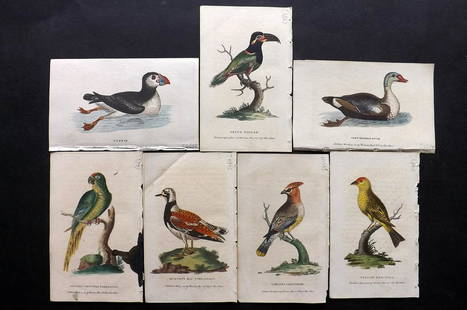
Sold2021After George Edwards C1800 Lot of 7 HCol Bird PrintsHand Colored Copper Plates Published 1798-1802 by Harrison et al., London for "The Naturalist's Pocket Magazine; or, Compleat Cabinet of the Curiosities and Beauties of Nature" Most are engraved afterSee Sold Price
Sold2022Six Atlas of New York and Vicinity, hand colored engraved maps including Sommers, Patterson,Six Atlas of New York and Vicinity, hand colored engraved maps including Sommers, Patterson, Wakefield, Ossining, City Island, and North Salem, 16 3/4" x 13 3/4". Provenance: Originally from Credit SuSee Sold Price
Sold2020Hand colored copper engraved map by Homann, 1715Johann Baptist Homann (German, 1664-1724), hand colored copper engraved map, 1715, 'Provinciae XVII Infer. Germaniae,' depicting the Netherlands, Belgium, and Luxembourg in addition to parts of FranceSee Sold Price
Sold2021c 1730 Seutter Map: Novi Belgii, in America ...Historic Maps c. 1730 Historic Rare Earlier State of Seutter's Important American Northeast Map & New York City Restitutio View c. 1730 Hand-Colored Copper-Engraved Map titled, "Recens Edita totius NoSee Sold Price
Sold2022Barclay, James C1800 Hand Col Map. Western Hemisphere"The New World or Western Hemisphere" Hand Colored Copper Engraved Map Published C1800 Halifax & Newcastle, England for "Barclay's Universal English Dictionary…" by James Barclay. Maps Engraved by CSee Sold Price
Sold2022Barclay, James C1800 Hand Col Map. Asia ContinentHand Colored Copper Engraved Map Published C1800 Halifax & Newcastle, England for "Barclay's Universal English Dictionary…" by James Barclay. Maps Engraved by Clerk, Milton and others. Paper Size: 1See Sold Price
Sold2022Barclay, James C1800 Hand Col Map. GermanyHand Colored Copper Engraved Map Published C1800 Halifax & Newcastle, England for "Barclay's Universal English Dictionary…" by James Barclay. Maps Engraved by Clerk, Milton and others. Paper Size: 1See Sold Price
Sold2022Barclay, James C1800 Hand Col Map. ItalyHand Colored Copper Engraved Map Published C1800 Halifax & Newcastle, England for "Barclay's Universal English Dictionary…" by James Barclay. Maps Engraved by Clerk, Milton and others. Paper Size: 1See Sold Price
Sold2020Toms & Badeslade C1742 Hand Col Map of StaffordshireHand Colored Copper Engraved Map Published C1742, London for "Chorographia Britanniae, or a Set of Maps of all the Counties in England and Wales" by Thomas Badeslade and William Henry Toms. Paper SizeSee Sold Price
Sold2022Barclay, James C1800 Hand Col Map. ItalyHand Colored Copper Engraved Map Published C1800 Halifax & Newcastle, England for "Barclay's Universal English Dictionary…" by James Barclay. Maps Engraved by Clerk, Milton and others. Paper Size: 1See Sold Price
Sold2022Barclay, James C1800 Hand Col Map. England and WalesHand Colored Copper Engraved Map Published C1800 Halifax & Newcastle, England for "Barclay's Universal English Dictionary…" by James Barclay. Maps Engraved by Clerk, Milton and others. Paper Size: 1See Sold Price
Sold2021Wilkes, John 1807 HCol Map. Projection of Globes, MapsFinely Hand Colored Copper Engraved Map Published 1796-1828 London for "Encyclopaedia Londinensis, or universal dictionary of arts, sciences and literature" by John Wilkes et al. Paper Size: 10.5 x 8.See Sold Price
Sold2022Barclay, James C1800 Hand Col Map. HollandHand Colored Copper Engraved Map Published C1800 Halifax & Newcastle, England for "Barclay's Universal English Dictionary…" by James Barclay. Maps Engraved by Clerk, Milton and others. Paper Size: 1See Sold Price
Sold2022Barclay, James C1800 Hand Col Map. SwitzerlandHand Colored Copper Engraved Map Published C1800 Halifax & Newcastle, England for "Barclay's Universal English Dictionary…" by James Barclay. Maps Engraved by Clerk, Milton and others. Paper Size: 1See Sold Price
Sold2020Kitchin, Thomas C1785 Hand Col Map of Staffordshire, UKHand Colored Copper Engraved Map Published C1785, London for "Bowles's Pocket Atlas of the Counties of South Britain or England and Wales" by Carrington Bowles. Maps by Thomas Kitchin. Folds as issuedSee Sold Price
May 23Potter & Potter Auctions[“SOLDIER IN THE CIVIL WAR”]. Group of 8 Engraved Illustrat...$50
May 11Trillium Antique Prints & Rare BooksWilson - Cedar Bird, Red-bellied Woodpecker, Yellow-throated Flycatcher, & Purple Finch. 7$75


![[“SOLDIER IN THE CIVIL WAR”]. Group of 8 Engraved Illustrat... (1 of 4)](https://p1.liveauctioneers.com/928/328184/176813702_1_x.jpg?height=282&quality=70&version=1714496988)


