Sold2018CART DU MEXIQUE ET DES ETATS UNIS D'AMERIQUETitle: CART DU MEXIQUE ET DES ETATS UNIS D'AMERIQUE Maker: DEZAUCHE Origin: FRANCE Date/Period: 1783 Materials: COPPER ENGRAVING Dimensions: 48X65CM UPDATED VERSION OF DE L'ISLE'S MAP ENTITLED 'CARTESee Sold Price
Sold2016Map of Canada Framed Vintage 40s Print After 1720Map of Canada Framed Vintage 40-s Print After 1720 Guillaume De L'Isle Carte Du Canada Qui Comprend la Partie Septentrionale Des Etats Unis D'Amerique Canada and Great Lakes Map Approximately 21 5/8"See Sold Price
Sold2022c. 1788 French Map of the Eastern United StatesHistoric Maps c. 1788 Map, "Les Etats Unis de L'Amerique Septentrionale, Partie Orientale" (Eastern Part of the Northern United States of America) by M. (Rigobert) Bonne c. 1788 Map titled, "Les EtatsSee Sold Price
Sold2021Antique French Map of United States- Etats-Unis De L'Amerique Septentrionale Avec Les Isles Royale, De Terre Neuve, De St. Jean, L'Acadie &c.; Hand-colored; Ches Boudet Imprimeur du Roi; Paris; undated (circa 1785). One of the early maSee Sold Price
Sold2019Two Maps by Rigobert Bonne (1727-1794, Paris), Isles deTwo Maps by Rigobert Bonne (1727-1794, Paris), Isles de Cuba et de Jamaiqe, 1750; together with Les Etats Unis de L'Amerique Septentrionale les Royale de Terre Neuve, de St. Jean et L'Acadie; et partiSee Sold Price
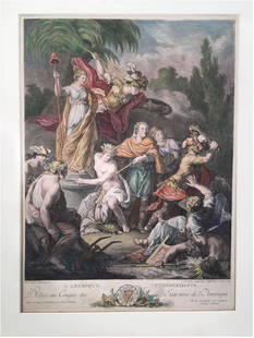
Sold2023Antoine BOREL: Color Engraving by Le VasseurExtremely rare, original 1778 engraving titled "L'Amerique Independante; Dediee au Congres des Etats Unis de l'Amerique" [Independent America; dedicated to the Congress of the United States of AmericaSee Sold Price
Sold2018Map, United States, 1784, first map of the nationMap, United States, 1784,"Carte Des Etats-Unis De L'Amerique Suivant le Traite de Paix de 1783. Dediee et Presentee A.S. Excellence M. Benjamin Franklin Ministre Pleinipotentaire des Etats-Unis", theSee Sold Price
Sold2018Buchon: Antique Map of USA territorial developmentTITLE/CONTENT OF MAP: 'Carte de l'adjonction progressive des divers états au territoire et à l'union constitutionelle des États-Unis de l'Amérique du Nord 1825' This fascinating map shows the terrSee Sold Price
Sold202118TH CENTURY FRENCH MAP OF SOUTHEASTERN USRigobert Bonne (French, 1727-1794). "Carte De la Partie Sud Des Etats Unis De L'Amerique Septentrionale" -circa 1780, engraving. Provenance: From the Lifetime Collection of Billy S. Arant, Jr., ChattaSee Sold Price
Sold20211800 Weld Map of Northern United States and Great LakesTitle: 1800 Weld Map of Northern United States and Great Lakes -- Partie des Etats-Unis de L'Amerique Septentrionale Cartographer: I Weld Year / Place: 1800, Paris Map Dimension (in.): 16.1 X !8.2 in.See Sold Price
Sold2017E.F. Delamarche, French Framed Map"Etats-Unis de L'Amerique." Approx. 18" x 23" sight, 22 1/2" x 28 1/2" framed. (6215) Yellowing. Damage to glass.See Sold Price
Sold2022(CIVIL WAR.) Jean-Rodolphe Mayer. Nouvelle Carte des Etats-Unis de l'Amerique du Nord… 2de(CIVIL WAR.) Jean-Rodolphe Mayer. Nouvelle Carte des Etats-Unis de l'Amerique du Nord… 2de Edition. Large hand-colored lithographed map of the United States with a keyed reference table numberinSee Sold Price
Sold2023"Carte De La Partie Nord, Des Etats Unis, de L'Amérique Septentrionale" by Rigobert Bonne. Paris,“Carte De La Partie Nord, Des Etats Unis, de l'Amerique Septentrionale” by Rigobert Bonne, Ca. 1780s. This post-revolutionary war map features a detailed overview of the mid-Atlantic regioSee Sold Price
Sold2023EUSTACHE-HYACINTHE LANGLOIS (1777-1837) A MEXICAN TEXAS MAP, "Etats Unis et Partie de L'AméEUSTACHE-HYACINTHE LANGLOIS (1777-1837) A MEXICAN TEXAS MAP, "Etats Unis et Partie de L'Amérique Anglaise et du Mexique," PARIS, CIRCA 1830, lithograph on cream wove paper with hand color, probabSee Sold Price
Sold2016L'Amerique Septentrionale, F. Delamarche 1785Title: Etats-Unis De L'Amerique Septentrionale Avec Les Isles Royale, De Terre Neuve, De St. Jean, L'Acadie Subject: United States/American Revolution Maker: F. Delamarche Date: 1785, Paris Size: 18.7See Sold Price
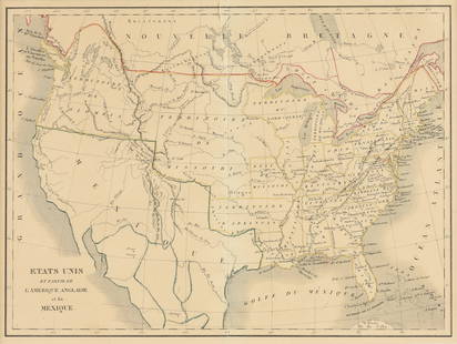
Sold2019Les Etats Unis de I'Amérique Septentrionale, partieTITLE/CONTENT OF MAP: 'Les Etats Unis de I'Amérique Septentrionale, partie Occidentale [The United States of North America, western part]' The top image on the right hand side shows the entire map. TSee Sold Price
Sold2016Landscape. United States. North America. 1839.Print of steel engraving titled „Palissades naturelles de l‘Hudson“.Drawn by Milbert.Engraved by unknown.From „Etats-Unis D‘Amerique by M. Roux de Rochelle. Published by Firmin didot freres.See Sold Price
Sold2017Bonne: Antique Map of Northeastern Canada, 1783Map: Partie de l'Amerique Septentrionale qui comprend le Canada, la Louisiane, le Labrador, le Grenland, les Etats Unis, et la Floride Cartographer: Bonne Place & Date: Paris / 1783 Size: 17" x 11 5/8See Sold Price
Sold2016Waterfall near the baths of Schooley. North America.Print of steel engraving titled „Chute d‘eau pres les bains de Schooley“.Drawn by Milbert.Engraved by L. Thienon.From „Etats-Unis D‘Amerique by M. Roux de Rochelle. Published by Firmin didotSee Sold Price
Sold2023Carte des Etats-Unis du Mexique & Guatemala. Mexico USA Southwest LAPIE 1829 mapCAPTION PRINTED BELOW PICTURE: Carte des Etats-Unis du Mexique // Carte du Guatemala, ou Provinces-Unies de l'Amérique centrale [The United States of Mexico // Guatemala, or the United ProvincesSee Sold Price
Sold2016Map of New York Bay. North America. 1839.Print of steel engraving titled „Plan de la baie de New-York“.Drawn by unknown.Engraved by Blondeau.From „Etats-Unis D‘Amerique by M. Roux de Rochelle. Published by Firmin didot freres. Paris.See Sold Price
Sold2016Map of United States. North America. 1839.Print of steel engraving titled „Etats-Unis“.Drawn by Th. Duvotenay.Engraved by unknown.From „Etats-Unis D‘Amerique by M. Roux de Rochelle. Published by Firmin didot freres. Paris. 1839.The UnSee Sold Price
Sold2016Map of a prison. United States. North America. 1839.Print of steel engraving titled „Plan du Penitentiaire“.Drawn by unknown.Engraved by unknown.From „Etats-Unis D‘Amerique by M. Roux de Rochelle. Published by Firmin didot freres. Paris. 1839.TSee Sold Price
Sold2017de la Tour: Antique Map of North America, 1779Map: L'Amerique Septentrionale ou se Remarquent les Etats Unis Cartographer: Brion de la Tour Place & Date: Paris / 1779/1783 Size: 28 5/8" x 19 7/8" Condition: full wash color; cleaned and sized; minSee Sold Price
Jun 14DuMouchellesRigobert Bonne (French, 1727-1794) Hand Colored Engraving Ca. 18th Century, Les Etats Unis De$50
1 day LeftJasper52Extremité Meridionale de l'Amérique Tierra del Fuego Magellan Str BONNE 1788 map$35
Featured1 day LeftJasper52Carte Générale de l'Amerique méridionale. South America. LAPIE 1829 old map$80
1 day LeftJasper52La Partie la plus Méridionale de l’Amérique'. Patagonia. BELLIN/SCHLEY 1757 map$45
1 day LeftJasper52La Partie la plus Méridionale de l’Amérique'. Patagonia. Chile. BELLIN 1753 map$50
1 day LeftJasper52La partie méridionale du Brésil et du Perou. SANTINI/D'ANVILLE 1784 old map$80
1 day LeftJasper52Amér. Sep. Partie de l'Amérique Russe #14 Colombia profile VANDERMAELEN 1827 map$55
BonhamsHERMES Paris. Cendrier en porcelaine 'Early America'. D'après le carré dessiné pa...€150
1 day LeftJasper52L'Amérique Méridionale by BRION DE LA TOUR. South America 1777 old map$35
BonhamsAFRICA L'Afrique suivant les dernières observations de M. Hass... Paris, Georges-Louis Le R...£10
9 hrs LeftJasper521719 Chatelain Map of the Adriatic and Venice Republic -- Carte de Geographie des Differents Etats$190
1 day LeftJasper52Partie méridionale Du Bresil… River Plate basin Brazil Uruguay. BONNE 1780 map$25
1 day LeftJasper52Amér Mér Colombie & Brésil 9 Peru Colombia Amazonas Brazil VANDERMAELEN 1827 map$70


![Les Etats Unis de I'Amérique Septentrionale, partie: TITLE/CONTENT OF MAP: 'Les Etats Unis de I'Amérique Septentrionale, partie Occidentale [The United States of North America, western part]' The top image on the right hand side shows the entire map. T](https://p1.liveauctioneers.com/5584/147595/74587359_1_x.jpg?height=310&quality=70&version=1565730371)


