Sold2020FRAMED FRENCH MAPSFRAMED FRENCH MAPS. AUTRICHEN, LEVEEA L'INITIVEDU, COMTE DE FER PARIS, CARTE DE CABINETS DES PAY-BES. Height: 27 in. by Width: 32 in.See Sold Price
Sold2022FRAMED FRENCH MAPSFRAMED FRENCH MAPS. AUTRICHEN, LEVEEA L'INITIVEDU, COMTE DE FER PARIS, CARTE DE CABINETS DES PAY-BES.See Sold Price
Sold2024Nicholas de Fer, Map of California of 1705Nicholas de Fer (1646-1720) Map of California of 1705 (Cette carte de Californie et du Nouveau Mexique, 1705); together with two other California related framed ephemera.Assumed second state (1705) ofSee Sold Price
Sold2021De Fer Map of Italy, 1705[Europe, Italy] DE FER, Nicolas (1646-1720). Routes des Postes D'Italie... Engraved map with full original color and minor manuscript annotations. Paris, c. 1705. 19" x 27" sheet. This unusual, largeSee Sold Price
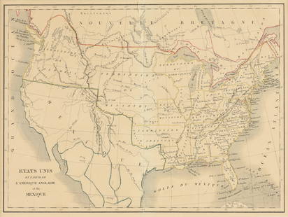
Sold2023EUSTACHE-HYACINTHE LANGLOIS (1777-1837) A MEXICAN TEXAS MAP, "Etats Unis et Partie de L'AméEUSTACHE-HYACINTHE LANGLOIS (1777-1837) A MEXICAN TEXAS MAP, "Etats Unis et Partie de L'Amérique Anglaise et du Mexique," PARIS, CIRCA 1830, lithograph on cream wove paper with hand color, probabSee Sold Price
Sold2018de Fer: Antique Map of Grenada & Andalusia, Spain 1706Title/Content of Map: Les Royaumes de Grenade et d'Andalousie Cartographer: de Fer Place & Date: Paris / 1706 Size: 19 1/8" x 17 3/8" Condition: wash and outline color; washed and backed, with small wSee Sold Price
Sold2017de Fer: Antique Map of Castile & Leon, 1706Map: La Castille Vieille et Nouvelle, l'Estramadura de Castille et de Leon Cartographer: de Fer Place & Date: Paris / 1706 Size: 23 1/4" x 17 3/8" Condition: wash and outline color; washed and backed,See Sold Price
Sold2017de Fer: Antique Map of the Caribbean Islands, 1705Map: Les Isles de L'Amerique Connues Sous le Nom d'Antilles Cartographer: de Fer Place & Date: Paris / 1705 Size: 13 1/8" x 8 3/4" Condition: outline color; some nicks along edges of margins The fasciSee Sold Price
Sold2022Scarce 1705 map of North America by Nicolas de Fer (Calif. as island)Nice example of de Fer's scarce map of North America, first published in Paris in 1693. This specimen with a 1705 date is from the 1723 edition of de Fer’s Petit et Nouveau Atlas and features laterSee Sold Price
Sold2018Bellin: Antique Map Gulf of Mexico & West Indies, 1754Title/Content of Map: Carte du Golphe de Mexique et des Isles de l'Amerique Cartographer: Jacques Bellin Place & Date: Paris / 1754/1760 Size: 14 3/4" x 10 3/4" Condition: b&w; old folds as published;See Sold Price
Sold2017Bellin: Antique Map of Gulf of Mexico / Caribbean, 1757Map: Carte du Golphe de Mexique et des Isles de l'Amerique Cartographer: Jacques Bellin Place & Date: Paris / 1757 Size: 15" x 10 3/4" Condition: outline color; washed; some nicks and splits in edgesSee Sold Price
Sold2021de Fer, Nicolas 1717 Map. America. California as Island"L'Amerique, Meridionale et Septentrionale..." Copper Engraved Map Published 1717, Paris for "Introduction a la Geographie" by Nicolas de Fer. Folds as issued. Paper Size: 14 x 10 inch (36 x 25cm) VerSee Sold Price
Sold2017de Fer/Danet: Map of Santo Domingo, 1649Map; L'Isle St. Domingue ou Espagnole Decouverte l'An 1492. Par les Espagnols Cartographer: de Fer / Danet Place & Date: Paris / 1723 Size: 23" x 17" DeFer's oddly configured, but striking St. DominguSee Sold Price
Sold2018de Fer/Pierre Mortier: Parish Map of JamaicaDe Fer's wonderfully detailed map of Jamaica, divided into parishes, with rich topographical detail and many coastal place names. From de Fer's Atlas Curieux.; RS2656; de Fer/Pierre Mortier; Paris / 1See Sold Price
Sold2020[MILITARY ARCHITECTURE] 9 plans together[Fortifications and Military Architecture.] A collection of nine maps sold together including Fer, Nicolas de. PLAN DE LA VILLE OUVRAGES ET CHTEAU DE NAMUR. Paris, [c. 1692] 36 x 51.5 cm. **And eightSee Sold Price
Sold2021de Fer, Nicolas 1717 World Map. California as Island"Mappe-Monde ou Carte Generale de la Terre" Copper Engraved Map Published 1717, Paris for "Introduction a la Geographie" by Nicolas de Fer. Folds as issued. Paper Size: 14 x 10 inch (36 x 25cm) Very mSee Sold Price
Sold2021de Fer, Nicolas 1717 Antique Map. Europe"L'Europe Suivant les Nouvelles Observations" Copper Engraved Map Published 1717, Paris for "Introduction a la Geographie" by Nicolas de Fer. Folds as issued. Paper Size: 14 x 10 inch (36 x 25cm) GoodSee Sold Price
Sold2021de Fer, Nicolas 1717 Antique Map. Africa"L'Afrique dressee selon les dernieres Relat" Copper Engraved Map Published 1717, Paris for "Introduction a la Geographie" by Nicolas de Fer. Folds as issued. Paper Size: 14 x 10 inch (36 x 25cm) GoodSee Sold Price
Sold2021de Fer, Nicolas 1717 Antique Map. Asia"L'Asie. Suivant les nouvelles decouvertes dont les point principaux sont placez sur les observation" Copper Engraved Map Published 1717, Paris for "Introduction a la Geographie" by Nicolas de Fer. FoSee Sold Price
Sold2018de Fer: Malta with Grand Masters’ Coats of ArmsCartographer: de Fer Place/Date: Paris / 1722 Size: 20" x 14 3/4" Condition: a few tiny wormholes along centerfold; ; ; ; De Fer's magnificent large-scale, map of Malta, Gozo, and Comino, showing townSee Sold Price
Sold2018(2) antique maps of Europe by Nicolas De Fer(2) antique maps of Europe by Nicolas De Fer, "Les Suisses, Leurs Sujets et Leurs Alliez", black and white map, 1715 and "Le Golfe De Venise", hand-colored map, 1716, by Nicolas De Fer and P. StarckmaSee Sold Price
Sold2017de Fer/Pierre Mortier: Antique Plan of Havana, 1702Map: Baye et Ville de Havana ou St. Christoval Cartographer: de Fer/Pierre Mortier Place & Date: Paris / 1702 Size: 12 3/8" x 8 5/8" Condition: b&w; minor spotting along outer edge of bottom margin ASee Sold Price
Sold20241717 MAP of AMERICA antique authentic CALIFORNIA AS AN ISLAND L'AmeriqueAmericas. L'Amerique, Meridionale et Septentrionale Dressee Selon les Dernieres Relations et Suivant les Nouvelles Decouverte... by Fer (Nicholas de) (1646-1720) engraver Inselin, C. A Paris :b Chez lSee Sold Price
Sold2022CHARLES FURNE (1794-1859) A MAP OF THE U.S. AND MEXICO,CHARLES FURNE (1794-1859) A MAP OF THE U.S. AND MEXICO, "États-Unis & Méxique.," PARIS, CIRCA 1851, lithograph with hand coloring on paper, plate No. 25, Lemercier, lithographer at rue de SeSee Sold Price
Featured3 days LeftJasper52Carte du Golfe du Mexique et des Isles de l'Amerique' Caribbean BELLIN 1754 map$200
May 14Fleischer's Auctions1755 Map Partie de l'Amerique Septentrionale, qui comprend Le Cours de L'Ohio...$200(3 bids)
4 days LeftHunt and Peck Estate Services, Inc.Sanson & Jaillot "Le Royaume de Naples Divisé en Douze Provinces"$200
6 days LeftTrillium Antique Prints & Rare BooksPrevost - Map of the South Pacific Ocean with New Holland (Australia), New Zealand, and part of the$50(1 bid)
6 days LeftTrillium Antique Prints & Rare BooksMaitres Affiches by De Riquer - Maison Napoleon. 204$50
6 days LeftTrillium Antique Prints & Rare BooksMaitres Affiches by Toulouse-Lautrec - Moulin Rouge - La Goulue. 122$50


![[MAP]. FER, Nicolac de.Ville de Mexique. [Paris, 1715]. First Image](https://p1.liveauctioneers.com/514/38480/16487192_1_x.jpg?height=300&quality=1&version=1363614971&width=300)
![[MAP]. FER, Nicolac de.Ville de Mexique. [Paris, 1715]. First Image](https://p1.liveauctioneers.com/514/38480/16487192_1_x.jpg?height=300&quality=95&version=1363614971&width=300)


![De Fer Map of Italy, 1705: [Europe, Italy] DE FER, Nicolas (1646-1720). Routes des Postes D'Italie... Engraved map with full original color and minor manuscript annotations. Paris, c. 1705. 19" x 27" sheet. This unusual, large](https://p1.liveauctioneers.com/1968/216191/110783529_1_x.jpg?height=310&quality=70&version=1629990486)


![[MILITARY ARCHITECTURE] 9 plans together: [Fortifications and Military Architecture.] A collection of nine maps sold together including Fer, Nicolas de. PLAN DE LA VILLE OUVRAGES ET CHTEAU DE NAMUR. Paris, [c. 1692] 36 x 51.5 cm. **And eight](https://p1.liveauctioneers.com/1124/187577/94368877_1_x.jpg?height=310&quality=70&version=1607095126)


