Sold2023Map of 1859. Patagonia, Falkland Islands by ColtonTitle: Map of 1859. Patagonia, Falkland Islands by Colton Date/Period: 1859 Materials: Hand colored steering engraved Size: 17 1/2 x 14 1/2” br>Patagonia is still not controlled by Chile or ArgeSee Sold Price
Sold2018Map of Patagonia & Falkland Islands, 1859Title/Content of Map: Patagonia & Falkland Is. Date Printed: 1859 Cartographer: Material/Medium: Paper Size: 14 x 17" Provenance: New York Please note that this lot has a confidential reserve. When yoSee Sold Price
Sold2017Colton: Antique Map of Patagonia, Falkland Islands 1861Title/Content of Map: Patagonia, Falkland Islands Date Printed: 1861 Cartographer: J.H. Colton Material/Medium: Paper Size: 17 1/2" x 14" Hand colored, steel engraved. From 'Colton's General Atlas.' PSee Sold Price
Sold2016Patagonia, South Orkney, South Georgia & FalklandOriginal engraving by Colton, 1875. Map features insets of South Orkney, South Georgia & Falkland Islands. Dimensions: 13 3/4" x 17 1/4" Shipping Domestic: Shipping rates are determind by destination.See Sold Price
Sold2017Tallis: Antique Map Falkland Islands & Patagonia, 1851Title/Content of Map: 1851 Tallis Map of Falkland Islands and Patagonia -- Falkland Islands and Patagonia Date Printed: 1851, London Cartographer: J Tallis Size: 13.3 x 9.6 in. A very attractive map iSee Sold Price
Sold2021Tallis, John (Pub) 1852 Map Falkland Islands, PatagoniaSteel Engraved Map with Original Outline Hand Color Published 1852-56 by John Tallis, London for "The Universal Pronouncing Dictionary" by Thomas Wright. Drawn & Engraved by John Rapkin. Centre fold aSee Sold Price
Sold2018Bellin: Patagonia / Magellanica / Falkland Islands 1753Carte Reduite de la Partie la plus Meridionale de l'Amerique Bellin's detailed map of the "southernmost part of America"— Patagonia, Tierra del Fuego, and the Falkland, or Malouine, islands, from thSee Sold Price
Sold2018Meyer: Patagonia, Magellanica, Falkland IslandsReserve Reduced! Title of Map: Sudlichster Theil von America enthaltend Patagonia, Feuerland & Falklands Gruppe 1857 Cartographer: Joseph Meyer / Bibliographischen Instituts Place / Date: HildburghausSee Sold Price
Sold20231859 Map of Massachusetts and Rhode Island. Insert of Boston by ColtonTitle: 1859 Map of Massachusetts and Rhode Island. Insert of Boston by Colton1859 Materials: Steel engraved Size: 17 1/2 x 14 1/2” Massachusetts and Rhode Island. With insert of Boston and surroundiSee Sold Price
Sold2019Falkland Islands And Patagonia.Title: Falkland Islands And Patagonia. Publication Date: 1850 Cartographer: RAPKIN, J. Publisher: TALLIS, J. & F.Size: 13.5Height - 9.75Width Interesting maps of southern Argentina decorated with vignSee Sold Price
Sold2018Colton: Antique Map, Sizes of Lakes and Islands, 1859Title/Content of Map: Sizes of Lakes and Islands by Colton Date Printed: 1859 Cartographer: H.J. Colton Material/Medium: Paper Size: 17 1/2" x 15" Hand colored steel engraved Map. From 'Colton's GenerSee Sold Price
Sold2018Map of Falkland IslandsReserve Reduced! Title/Content of Map: Map of Falkland IslandsDate: 1770 Cartographer: LODGE, J. Material/Medium: D. HENRY/F. NEWBERY Size: 6.5 x 9.3 inches in the latitude of 51 deg. 22' South, longiSee Sold Price
Sold20201859 Colton Map of Paris -- The Environs of ParisTitle: 1859 Colton Map of Paris -- The Environs of Paris Cartographer: J Colton Year/Place: 1859, New York Size: 12.1 X 14.7 in. Additional Information: This is a very attractive city map of greater PSee Sold Price
Sold2023Map of 1859 Switzerland by ColtonTitle: Map of 1859 Switzerland by Colton Date/Period: 1859 Materials: Steel engraved Size: 17 1/2 x 14 1/2” Switzerland. 1859. By J. H. Colton & G. W. Colton. From "General Atlas". Published inSee Sold Price
Sold2023Map of 1859. South America by ColtonTitle: Map of 1859. South America by Colton Date/Period: 1859 Materials: Hand colored steering engraved Size: 17 1/2 x 14 1/2” South America. Which has a large Bolivia with a sea coast. Peru extSee Sold Price
Sold2024SOUTH AMERICA. Inset Buenos Aires Valparaiso Falklands Rio de Janeiro 1891 mapTITLE/CONTENT OF MAP: 'South America; Inset maps of Buenos Ayres; Valparaiso; Falkland Islands; Rio de Janeiro' DATE PRINTED: 1891 IMAGE SIZE: Approx 46.5 x 32.5cm, 18.25 x 12.75 inches (Large); PleasSee Sold Price
20231859 Map of Texas. By ColtonTitle: 1859 Map of Texas. By Colton Date/Period: 1859 Materials: Hand colored steering engraved Size: 17 1/2 x 14 1/2” br>Texas right before the civil war, inserts the northern part of the stateSee Sold Price
Sold20231859 Map of Texas. By ColtonDescriptionTitle: 1859 Map of Texas. By ColtonDate/Period: 1859Materials: Hand colored steering engravedSize: 17 1/2 x 14 1/2”br>Texas right before the civil war, inserts the northern part of thSee Sold Price
20231859 Map of Florida by ColtonTitle: 1859 Map of Florida by Colton Date/Period: 1859 Materials: Steel engraved Size: 17 1/2 x 14 1/2” Florida with Florida keys in the insert. From before the civil war. By J. H. Colton & G. WSee Sold Price
Sold2023New Zealand Sandwich Galapagos Islands. Papuan Archipelago. Melanesia 1859 mapNew Zealand. // Sandwich Islands, or Hawaiian Group, // Galapagos Islands // Papuan Archipelago' by John Bartholomew (1859). Antique engraved atlas map with original hand colour/color, 37.0 x 53.5cm,See Sold Price
Sold20231859 Map of Florida by ColtonTitle: 1859 Map of Florida by Colton1859 Materials: Steel engraved Size: 17 1/2 x 14 1/2” Florida with Florida keys in the insert. From before the civil war. By J. H. Colton & G. W. Colton. From "GeSee Sold Price
Sold2023Map of 1859. Colombia, Venezuela & Ecuador by Colton.Title: Map of 1859. Colombia, Venezuela & Ecuador by Colton.Date/Period: 1859Materials: Hand colored steering engravedSize: 17 1/2 x 14 1/2”Venezuela, Colombia still controls Panama, and EcuadorSee Sold Price
Sold20231859 Map of Connecticut by ColtonTitle: 1859 Map of Connecticut by Colton Date/Period: 1859 Materials: Steel engraved Size: 17 1/2 x 14 1/2” Connecticut. Shows, rivers, lakes, counties cities, towns, villages, roads, and rail lSee Sold Price
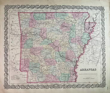
Sold20231859 Map of Arkansas by ColtonTitle: 1859 Map of Arkansas by Colton Date/Period: 1859 Materials: Steel engravedSize: 17 1/2 x 14 1/2” Arkansas. From before the civil war. By J. H. Colton & G. W. Colton. From "General Atlas".See Sold Price
7 days LeftJasper521756 Port Julian, River, and True Justice Island, Patagonia, Argentina Map by G. Anson$25
16 hrs LeftJasper52Nouvelle Caledonie. Baies de Kuakue et de Uinne'. CHAMBEYRON sea chart 1891 map$100
May 15University ArchivesHamilton Fish 2 Special Passports Signed & Issued for Travel to Falkland Islands$100
1818 AuctioneersA cased set of 7 1980 Queen Mother 80th Birthday Silver Proof Commemorative Crowns including£55(1 bid)
1818 AuctioneersA cased set of 16 Royal Mint Silver Proof Medallions, 1981 Marriage of the Prince of Wales & Lady£120(1 bid)