Sold2017Adam & Charles Black: Map of Asia, 1854Map of Asia. Adam and Charles Black 1854, 17.25 x 12.5 inches Please note that this lot has a confidential reserve. When you leave a bid in advance of the auction, submit your maximum. Jasper52 will bSee Sold Price
Sold2016Map of Asia. 1854.Print of hand colored steel engraving titled „Carte Physique & Politique de L’Asie“.Drawn by L. Dussieux.Engraved by unknown.From „Atlas General De Geographie physique, politique et historiqueSee Sold Price
Sold2016Map of Asia Minor. 1854.Print of hand colored steel engraving titled „Asia Minor“.Drawn by L. Dussieux.Engraved by unknown.From „Atlas General De Geographie physique, politique et historique par L. Dussieux. Atlas de GSee Sold Price
Sold2017Map of Turkey in Asia, 1854Map of Turkey in Asia. Adam and Charles Black, 1854, 18 x 13 inches No Reserve: This lot starts at $1 and has no reserve as a courtesy so that collectors can determine the true market value on this auSee Sold Price
Sold2015Map of East Indies (Southeast Asia) by Colton, 1854Original engraving from A General Atlas by J.H. Colton, 1854. Map features decorative border and color key shows the Dutch, British, Spanish and Portugesse Possession. Dimensions: 17 1/4” x 20”See Sold Price
Sold2017The History of the War with Russia Maps, 1854Map: War with Russia with Tallis Maps,1854 (vol.1.) Cartographer: H Tyrrell and J Tallis Date: 1854 Origin: London Size: 12.8 x 9.6 inches for majority of maps A magnificent book on the War with RussiSee Sold Price
Sold2022LAPIE ORIGINAL ANTIQUE MAP ASIA MINOR 1831L' ASIE MINEURE 1831 SIZE: 25.5 X 20 INCHES APPROX. UNFRAMEDSee Sold Price
Sold2023MAP, Asia, PtolemySouthern Asia. Ptolemy/Ruscelli, Tabula Asiae IX, from Geographia Cl. Ptolemaei Alexadrini..., 1562 (circa). Black & White. This Ptolemaic map covers most of present-day Iran, Afghanistan, and PakistaSee Sold Price
Sold2023Lizars, Daniel 1831 LG Rare HC Map. Asia on 2 SheetsLarge Folio Copper Engraved Map Published 1831-2 by John Hamilton, Successor to Daniel Lizars, Edinburgh for "The Edinburgh Geographical and Historical Atlas..." First Edition by Daniel Lizars. Very fSee Sold Price
Sold2023Bowen, Thomas 1789 Large Map. Asia"A New & Accurate Map of Asia" Copper Engraved Map Published 1789-91 by C. Cooke, London for "The New Royal Encyclopedia, Or, Complete Modern Universal Dictionary of Arts and Sciences..." by William HSee Sold Price
Sold2021de Fer, Nicolas 1717 Antique Map. Asia"L'Asie. Suivant les nouvelles decouvertes dont les point principaux sont placez sur les observation" Copper Engraved Map Published 1717, Paris for "Introduction a la Geographie" by Nicolas de Fer. FoSee Sold Price
2023Antique Military Map - Asia - Luzon - Philippines - Manila Bay - South China SeaTitle: Antique Military Map - Asia - Luzon - Philippines - Manila Bay - South China Sea Date: 1899 Material: Paper Dimensions: 40” x 25” inches / 102 cm x 63 cm Descritpion: This black andSee Sold Price
Sold2017The Solar System, Theory of the Seaons Map, 1854The Solar System, Theory of the Seaons Map. Adam and Charles Black, 1854, 18 x 13 inches No Reserve: This lot starts at $1 and has no reserve as a courtesy so that collectors can determine the true maSee Sold Price
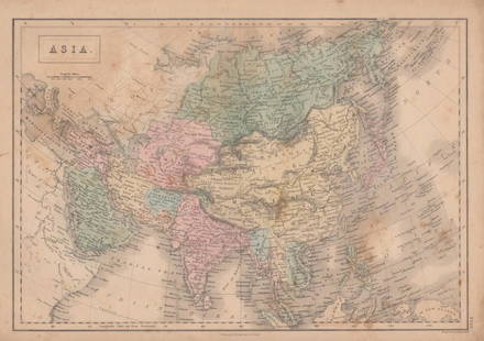
Sold2021Tallis, John (Pub) 1852 Map. Asia ContinentSteel Engraved Map with Original Outline Hand Color Published 1852-56 by John Tallis, London for "The Universal Pronouncing Dictionary" by Thomas Wright. Drawn & Engraved by John Rapkin. Centre fold aSee Sold Price
Sold2020Map Asia Buffier 1790Very beautiful map of Asia Author: Buffier Claude (1671-1737) Atlas: Geografia Universale del Padre Claudio Buffier... (italian ediction) Date: 1790 Technique: etching on copper Leaf Dimension: 21x20See Sold Price
Sold2022Barclay, James C1800 Hand Col Map. Asia ContinentHand Colored Copper Engraved Map Published C1800 Halifax & Newcastle, England for "Barclay's Universal English Dictionary…" by James Barclay. Maps Engraved by Clerk, Milton and others. Paper Size: 1See Sold Price
Sold2021Tallis, John (Pub) 1852 Map. AsiaSteel Engraved Map with Original Outline Hand Color Published 1852-56 by John Tallis, London for "The Universal Pronouncing Dictionary" by Thomas Wright. Drawn & Engraved by John Rapkin. Centre fold aSee Sold Price
Sold2021Guthrie, William 1798 Map. Asia ContinentCopper Engraved Map Published 1798, London for "A New Geographical, Historical and Commercial Grammar..." by William Guthrie. The maps are by John Senex, Thomas Kitchin and others. Folds as issued. PaSee Sold Price
Sold2024Churchill & Seale 1744 Folio Map. Asia"A Map of Asia from the latest and best Observations" by R. W, seale. Folio Copper Engraved Map Published 1704-47 [1744] London for "A Collection of Voyages and Travels..." By Awnsham & John ChurchillSee Sold Price
Sold2021Tallis, John (Pub) 1852 Map. Asia MinorSteel Engraved Map with Original Outline Hand Color Published 1852-56 by John Tallis, London for "The Universal Pronouncing Dictionary" by Thomas Wright. Drawn & Engraved by John Rapkin. Centre fold aSee Sold Price
Sold2019Barclay, James 1809 Antique Map. AsiaOutline Hand Coloured Copper Engraved Map Published 1809, Leeds for "Barclay's Complete and Universal Dictionary of the English Language..." by the Rev. James Barclay. Paper Size: 10 x 8 inch (26 x 20See Sold Price
Sold2023Walker, John C1805 Antique Map. AsiaCopper Engraved Map Published C1805, London for "The Universal Gazetteer: Being a Concise Description" [Walker's Geography] by John Walker. Folds as issued. Paper Size: 10 x 8 inch (25 x 20cm) Very miSee Sold Price
Sold2022Salmon & Jeffreys 1749 Map. AsiaCopper Engraved Map Published 1749, London for "A New Geographical and Historical Grammar" First or Early Edition by Thomas Salmon. Engraved by Thomas Jeffreys. Folds as issued. Paper Size: 10 x 8 incSee Sold Price
6 days LeftHunt and Peck Estate Services, Inc.1696 Jaillot Mapping The Ottoman Empire at the End of the 17th Century$140
1 day LeftTrillium Antique Prints & Rare BooksMitchell's A New Universal Atlas.. - Volume with 73 Maps$1,000(1 bid)
1 day LeftTrillium Antique Prints & Rare BooksPtolemy & Magini, pub. 1620 - Map of the Ancient World with Africa, Europe, Asia$50
5 days LeftJasper521680 Jansson/Duval Map of Middle East -- Tabula Itineris Decies Mille Graecorum sub Cyro Contra$140(1 bid)
May 16Potter & Potter AuctionsPOLAND, Edwin Christian (1903 – 1991). The Evergreen Playgr...$200
May 15University ArchivesFantastic Archive of Polar Explorer Roald Amundsen, Including Four Signatures$1,000
6 days LeftHunt and Peck Estate Services, Inc.Abraham Ortelius Natoliae, Quae Olim Asia Minor, Nova Descriptio$100


![Churchill & Seale 1744 Folio Map. Asia: "A Map of Asia from the latest and best Observations" by R. W, seale. Folio Copper Engraved Map Published 1704-47 [1744] London for "A Collection of Voyages and Travels..." By Awnsham & John Churchill](https://p1.liveauctioneers.com/3952/320085/171971828_1_x.jpg?height=310&quality=70&version=1708266709)


![Walker, John C1805 Antique Map. Asia: Copper Engraved Map Published C1805, London for "The Universal Gazetteer: Being a Concise Description" [Walker's Geography] by John Walker. Folds as issued. Paper Size: 10 x 8 inch (25 x 20cm) Very mi](https://p1.liveauctioneers.com/3952/311930/166897812_1_x.jpg?height=310&quality=70&version=1701713718)


