Sold2020Grand Cascapedia River 2006; Vol. IThe Grand Cascapedia River: A History by Hoagy B. Carmichael, Volume I. 292 pp. Illustrated. Meadow Run Press. Green cloth with leatherette spine and 5 raised bands. Measures 11.75 in. x 9 in. x 1.75See Sold Price
Sold2023Atlantic Salmon Model by Barry CoullAtlantic Salmon Model Barry Coull Cascapedia River, Quebec 2009 plaque is 41 in. long inscribed "16.5 Lbs, Little Camp Pool, July 13, 2003. Angler: Ron Swanson, Guide: Barry Coull." inscribed in penciSee Sold Price
Sold2022Vintage US Travel Destination Maps & BrochuresVintage travel destination magazines, brochures including a map for "The Mountain Empire of the West - Middle Park, Grand County, Colorado" (1934), 1940 maps of Yosemite, Yellowstone National parks asSee Sold Price
Sold2024Circa 1815 Engraved Map A Plan of the Grand of the New Townships on the Grand or Ottawa RiverCirca 1815 A Plan of the Grand of the New Townships on the Grand or Ottawa River. London 1815. Engraved map by J. Walker. From Joseph Bouchette's book. "Joseph Bouchette's books played an important paSee Sold Price
Sold20231850 RR map of Indiana showing Kankakee SwampDetailed map of Indiana in 1850 with railroads highlighted in red and canals in blue. Also shows common roads, towns, rivers, lakes and the Grand Kankakee Swamp, once the largest inland wetlands in thSee Sold Price
Sold20191792 Elwe Map of Turkish Empire in the Middle East andTitle/Content of Map: 1792 Elwe Map of Turkish Empire in the Middle East and Eastern Mediterranean -- Estats de l'Empire du Grand Seigneur des Turcs, en Europe, en Asie, et en Afrique, Divise en tousSee Sold Price
Sold20211840 Horsford View of Genesee River New York -- DeepTitle: 1840 Horsford View of Genesee River New York -- Deep Gorge of the Genesee, below the Middle Falls at Portage Cartographer: E Horsford Year / Place: 1840 c. Map Dimension (in.): 6.5 X 9.1 in. ThSee Sold Price
Sold2023Grand Canyon Magic Lantern Glass Slides 1890-1920s (43)Arizona Grand Canyon National Park. Years: 1890-1920s. Highlights of the Canyons, Rivers, Valleys, Colorado River, Plateau, Temples, Trails, Granite Gorge, Maps, etc. Collection of 43 Magic Lantern GlSee Sold Price
Sold20212 U.S. Coast Survey Maps, Catalina Harbor & West CoastLot of two U.S. Coast Survey Maps to include: Catalina Harbor, "1852" and Reconnaissance of the Western Coast of the United States, middle sheet, from San Francisco to the Umpquah River, "1854," frameSee Sold Price
Sold2016George Bonbright's Personal Size No. 1 PerfectionThe Lady Amherst fly, closely associated with the large salmon of Qubec's Grand Cascapedia was invented in 1925 by George B. Bonbright who at one time also owned and fished this reel. This is BonbrighSee Sold Price
Sold2018IATMUL, MASK, PAPUA NEW GUINEA20th c. Carved wood, shells 31" x 8" x 4" Provenance: Allan Stone Collection, New York There are mask-making villages all along the Sepik, but the Middle River is the most densely populated with overSee Sold Price
Sold2024Attributed to Ada V. Thomas (Chitimacha, 1924-1992) Native American Lidded BasketAttributed to Ada V. Thomas (Chitimacha, 1924-1992) Native American Lidded Basket Multi-colored double layered twilled basket and lid of dyed split cane, from the Grand River of St. Mary's Parish, LouSee Sold Price
Sold2020ANSEL ADAMS - The Tetons and Snake River, Grand TetonARTIST: ANSEL ADAMS TITLE: 'The Tetons and Snake River, Grand Teton NP, WY, 1942' MEDIUM: Silver Gelatin IMAGE SIZE: 7 1/2 x 9 1/4 in DESCRIPTION: This silver gelatin contact print is untrimmed and unSee Sold Price
Sold2022[MANUSCRIPT MAP-FLORIDA & MISSISSIPPI RIVER] Map Showing Raiford's Proposed Artificial River and[MANUSCRIPT MAP-FLORIDA & MISSISSIPPI RIVER] Map Showing Raiford's Proposed Artificial River and Plan to Continue the Western and Southern Inland System of Navigation to Harbors in the Atlantic. [FernSee Sold Price
Sold2016Map, Hudson River, Rev. War, Sauthier, 1776At the top of the map is written: "A Topographical Map of Hudsons River, with the Channels Depth of Water, Rocks, Shoals, &c. and the Country Adjacent, from Sandy-Hook, New York and Bay to Fort EdwardSee Sold Price
Sold2019ANSEL ADAMS - The Tetons and the Snake River, GrandArtist: Ansel Adams (American, 1902-1984). Title: "The Tetons and the Snake River, Grand Teton National Park, Wyoming". Medium: Original photogravure. Date: 1942. Printed later. Lot Note(s):See Sold Price
Sold2022Crevecoeur French Edition of Evans Map of Middle ColoniesCREVECOEUR, Michel Guillaume De (1735-1813). Carte Generale des Etats de Virginie, Maryland, Delaware, Pensilvanie, Nouveau-Jersey, New-York, Connecticut et Isle de Rhodes Ainsi que des Lacs Erie, OntSee Sold Price
Sold2020ANSEL ADAMS - The Tetons and the Snake River, GrandArtist: Ansel Adams (American, 1902-1984). Title: "The Tetons and the Snake River, Grand Teton National Park, Wyoming". Medium: Original photogravure. Date: Composed 1942. Printed later. DimensioSee Sold Price
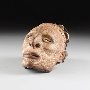
Sold2015AN LATMUL NATURALISTICALLY OVERMODELED AND PAINTEDAN IATMUL NATURALISTICALLY OVERMODELED AND PAINTED HUMAN SKULL, MIDDLE SEPIK RIVER, PAPUA NEW GUINEA, EARLY 20TH CENTURY, the finely modeled clay covered skull with portrait like facial features flankSee Sold Price
Sold2021CLYDE ASPEVIG, WESTERN IMPRESSIONIST LANDSCAPEClyde Aspevig (American/Montana, born 1951). "Above Island Camp, Wind River Wilderness, Wyoming" -1988, oil on canvas. Signed lower left, giltwood frame. Approx. 22.5" x 26.5" (frame), 16" x 20" (canvSee Sold Price
Sold2023IATMUL (MWAI) MASKIATMUL (MWAI) MASKPapua New Guinea, Middle Sepik River Region, Iatmul People, first half 20th century. Polychrome decorated carved wood mask having oblong face with elongated zoomorphic nose below a fSee Sold Price
Sold201619th C. PNG Iatmul Wood Basket Hook - FiguralOceania, Papua New Guinea, Middle Sepik River, Iatmul people, ca. late 19th to early 20th century CE. A hand carved female ancestral figure basket hook with an anchor form at the base for suspending bSee Sold Price
Sold2020Ansel Adams Tetons & Snake River Signed Silver GelatinANSEL ADAMS (1902-1984) The Grand Tetons and Snake River, Grand Teton National Park, Wyoming Silver gelatin 11 3/8" x 11 5/8" mount; image: 9 7/8" x 11 5/8" Signed in the mount in penSee Sold Price
Sold2020Ansel Adams Tetons & Snake River Signed Silver GelatinANSEL ADAMS (1902-1984) The Grand Tetons and Snake River, Grand Teton National Park, Wyoming Silver gelatin 10" x 9 1/4"; 7 1/4" x 9 1/4 (image) Signed in the mount in penSee Sold Price
5 days LeftJasper521752 Robert de Vaugondy Map of Middle East and Ancient Empires -- Antiquor Imperiorum Tabula, in qua$140
5 days LeftJasper521893 Civil War Map of Siege of Yorktown, Battle of Siloh and Army of Ohio Operations -- Plan of$55
5 days LeftJasper521893 Civil War Map of Knoxville Area -- Topographical Map of the Approaches and Defences of$70
5 days LeftJasper521893 Civil War Map of Yorktown -- Secession Works at Yorktown [with] The Position of Yorktown with$55
5 days LeftJasper521852 Owen Geological Maps of the Pigeon River Minnesota -- (1) Geological Map Coast View and Section$45
5 days LeftJasper521893 Civil War Map Washington, Paducah, KY and Logan's Cross-Roads plus Mill Springs, KY -- Defenses$70
2 days LeftTrillium Antique Prints & Rare BooksDavid Roberts - Grand Portico of the Temple of Philae, Nubia$200
Jun 14DuMouchellesMediterranean Revival Style Terracotta Architectural Element from the Grand Riviera Theatre,$1,800
Jun 14DuMouchellesMediterranean Revival Style Architectural Medallion from the Grand Riviera Theatre, Detroit,$1,800


![[MANUSCRIPT MAP-FLORIDA & MISSISSIPPI RIVER] Map Showing Raiford's Proposed Artificial River and: [MANUSCRIPT MAP-FLORIDA & MISSISSIPPI RIVER] Map Showing Raiford's Proposed Artificial River and Plan to Continue the Western and Southern Inland System of Navigation to Harbors in the Atlantic. [Fern](https://p1.liveauctioneers.com/292/250642/130213644_1_x.jpg?height=310&quality=70&version=1654271664)


![1893 Civil War Map of Yorktown -- Secession Works at Yorktown [with] The Position of Yorktown with (1 of 1)](https://p1.liveauctioneers.com/5584/331064/178466378_1_x.jpg?height=282&quality=70&version=1716924723)


