Sold2024Guillaume De L'Isle's 18th-Century Map of the AmericasGuillaume De L'Isle's 18th-Century Map of the AmericasGuillaume De L'Isle. CARTE D'AMERIQUE. Paris: Chez l'Auteur, 1722 or later. Copperplate engraving, hand-colored, presenting North and South AmericSee Sold Price
Sold2017Janvier/Vaugondy: Antique Map of the Americas, 1806Title/Content of Map: L'Amerique showing early independent United States Date Printed: 1806 Cartographer: Janvier/Vaugondy Material/Medium: Paper Size: 19" x 15" Hand colored. Copperplate engraving. SSee Sold Price
Sold202319th century. A large copperplate engraving map of the western hemisphere dating to 1832. Overall19th century. A large copperplate engraving map of the western hemisphere dating to 1832. Overall good condition. Some creasing and toning; beginning to split at center. Print at bottom cut so publishSee Sold Price
Sold2017Antoine Augustin Calmet - Prospect of the Town andAntoine Augustin Calmet - Prospect of the Town and Harbour of Ptolemais in Phaenicia (Acre), 1732. Copper plate engraving map. 30cm X 43cm / 11.8in X 16.9in. stains, hole. See Sold Price
Sold2022Virginia, Marylandia, et CarolinaTitle: Virginia, Marylandia, et Carolina Date Printed: 1714 Cartographer: Homann, J.B. Material/Medium: atlas map, copperplate engraving, original hand color Size: 19.5 x 23 Condition: The map has oveSee Sold Price
Sold2023After Heinrich Scherer, Likely Reproductions of Two Circa 1700 MapsAfter Heinrich Scherer, Likely Reproductions of Two Circa 1700 Mapscopperplate engravings with color as follows: Navigationes Praecipuae Europaeorum ad Exteras Nationes, showing global sea routes withSee Sold Price
Sold202216TH C. MAP OF AMSTERDAM BY BRAUN & HOGENBERG"Amstelredamum, Nobile Inferioris Germaniae Oppidum (..)" by Frans Hogenberg (1535-1590) / Georg Braun (1541-1622). Handcolored copperplate engraving, perspective map with buildings, from the first paSee Sold Price
Sold20201610 H/C Engraved Map of Worcestershire, SaxtonBeautiful 1610 Hand-colored Copperplate Engraving of Map of Worcestershire by Cartographer Christopher Saxton Entitled Wigorniensis Comitatus Sabrinae | Engraved map by William Hole | From Camden's BrSee Sold Price
Sold2024Three Antique Regional MapsThree Antique Regional Maps all copperplate engravings to include: Calabre (Paris: N.S. d'Abbeville, 1648), with handcolor, depicting Calabria and northeastern Sicily (overall sheet 18 x 23-3/4 in.) (See Sold Price
Sold2016Natolia, quae olim Asia minor by Joannis Blaeu 1650Map Title: Natolia, quae olim Asia minor Artist: Joannis Blaeu Publisher: Guiljelmum Blaeu, Amsterdam Date: 1650 Size: 15 x 19.5 inches Medium: Hand colored copper plate engraving A beautiful map of TSee Sold Price
Sold202019th CENTURY WILLIAM BLAEU "ITALY" ENGRAVING19th CENTURY WILLIAM BLAEU "ITALY" MAP HAND COLORED COPPER PLATE ENGRAVING. Height: 27 in. by Width: 31 in.See Sold Price
Sold2023Revolutionary War Map 1776A copperplate engraving of a map titled “Sketch of the Country Illustrating the late Engagement in Long Island”, which is a Revolutionary War map featuring Long Island and the site of the Battle oSee Sold Price
Sold2017Bellin: Antique Map of Angola and Congo, 1750Map: Angola and Congo Date Printed: 1750-60's Cartographer: Jacques Nicholas Bellin Material/Medium: Paper Size: 14" x 11" Copperplate engraving. Double Page Maps. From the Atlas De L'Histoire GeneralSee Sold Price
Sold2017Bellin: Antique Map of St. Lucia, 1750sMap: St. Lucia Date Printed: 1750's-60's Cartographer: Jacques Nicholas Bellin Material/Medium: Paper Size: 14 1/4" x 10" Condition: Excellent Copperplate engraving. Double page Map. Atlas De L'HistoiSee Sold Price
Sold2017Bellin: Antique Map of Mongolia Tartary Region, 1750Map: Mongolia Tartary Region Date Printed: 1750-60's Cartographer: Jacques Nicolas Bellin Material/Medium: Paper Size: 14" x 9 3/4" Condition: Excellent Copperplate engraving. Double page Map. From thSee Sold Price
Sold2017Bellin: Antique Map of Eastern Siberia, 1750Map: Eastern Siberia Date Printed: 1750-60's Cartographer: Jacques Nicolas Bellin Material/Medium: Paper Size: 14" x 11" Condition: Excellent Copperplate engraving. Double page Map. From the Atlas DeSee Sold Price
Sold2018Scarce Large 1634 Map of Americas by M. MerianRare Large Copperplate Engraved Map of the Americas Entitled "America Nouiter Delineata" by Matthäeus Merian (1593-1650) | | Title: America nouiter delineata Title (alt.): America noviter delineata |See Sold Price
Sold2016Regni Sinae vel Sinae Propriae by Homann Heirs 1745Map Title: Regni Sinae vel Sinae Propriae Artist: Homann Heirs Publisher: Homann Heirs, Nuremberg Date: 1745 Size: 22.5 x 20.2 inches Medium: Hand colored copper plate engraving A very detailed map ofSee Sold Price
Sold2019'A New General Map of America' Dated 1747Antique map of America in copper plate engraving by Emanuel Bowen dated 1747, London. COA from Marlborough Antiques on verso. Has been hand colored, framed in burl wood. Measures 20.25"H x 23.25"W fraSee Sold Price
Sold2024Antique North America West Indies Caribbean MapAn antique hand-colored copperplate engraving on rag paper map titled "Part of North America (West Indies)" by Malachy Postlethwayt (English, 1707-1767). This large map depicts Florida, the Bahamas, PSee Sold Price
Sold2017Thomas & Andrews: Antique Map of Massachusetts, 1796Map: Massachusetts Date: 1796 Medium: Original copperplate engraving From Morse's Universal Geography by Thomas & Andrews, Boston, 1796 Dimensions: 15" x 12.5" Unframed. Please note that this lot hasSee Sold Price
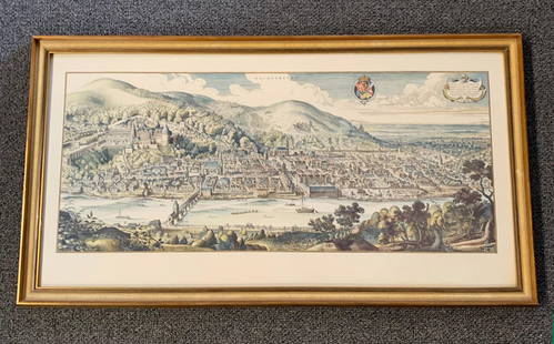
Sold20201620 Hand-colored Copperplate Engraved Haidelberga MapHeidelberg-Panorama von Matthaeus Merian 1620 - Description''': historic views of Heidelberg, Germany Birds Eye View Heidelberg 1620 Rare Copperplate Engraving by Matthäus Merian MAP - MatthäusSee Sold Price
2018U.S GOVERNMENT SURVEY COPPER MAP PLATES, SET OF 3Park Ridge, NJ-NY US Government Copper Map Engravings for Park Ridge, NJ-NY, scale 1:31,680 surveyed 1934-1944. The Original Master Set engraved on 3 plates measures approximately 21 in. H x 17 in. W.See Sold Price
Sold2019Two Atlas Maps; Portugal and the AmericasLondon: J. Carey, 1825. A New Map of the Kingdom of Portugal, divided into its provinces from the latest authorities by John Carey, engraver. Copper plate engraved map with hand color on T.Edmonds watSee Sold Price
Oct 05Ripley Auctions18th century Map of the Americas by Jean Baptiste Louis Clouet (c. 1730-1790), copper, engraving on$100
Oct 05Ripley AuctionsDe Fer Map of the Americas (Paris, 1726) by Nicolas de Fer (France, 1646-1720), copper engraving on$400
Oct 05Ripley Auctions“Visscher’s American Islands” Map (Insulae Americanae) by Nicolaes Visscher I (1619-1709)$800
Oct 05Ripley AuctionsMap of Hungary (Royaume de Hongrie) by Georges-Louis Le Rouge (c. 1707-1790), copper engraving on$50
1 day LeftJasper521641 MAP of ITALY antique authentic TERRITORIUM BONONIENSE IL BOLOGNESE original$160
3 days LeftLeland LittleRobert de Vaugondy's 18th-Century French Map of North America's Eastern Seaboard$50
Oct 05Ripley AuctionsBertius Map of the Americas (Paris, 1627) by Petrus Bertius (France, 1565-1629), engraving on papier$400
5 days LeftTrillium Antique Prints & Rare BooksDe Wit after Blaeu - Map of China and Japan, eastern Asia$75(1 bid)
5 days LeftBrunk AuctionsJohn Mitchell - A Map of the British and French Dominions in North America, 1755-1757$24,000
Oct 26Premier Auction Galleries(NEW ENGLAND.) Willem Blaeu. Nova Belgica et Anglia Nova Map$200(1 bid)
Lodestar AuctionsAntique 1719 Matthaeus Merian Verbafeum Botanical Hand Colored Copper plate Engraving$75