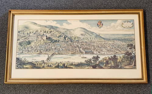
Sold20201620 Hand-colored Copperplate Engraved Haidelberga MapHeidelberg-Panorama von Matthaeus Merian 1620 - Description''': historic views of Heidelberg, Germany Birds Eye View Heidelberg 1620 Rare Copperplate Engraving by Matthäus Merian MAP - MatthäusSee Sold Price
Sold2020John Senex Map of North and South America 1719-17John Senex (1678–1740), "A New Map of America from the Latest Observations," London, ca. 1719-1721. Hand colored copperplate engraved map of North and South America, from Senex's "New General ASee Sold Price
Sold2022Nova Hispania Nova Galicia Guatimala. 1671.[Map/South America] Ogilby, John; Montanus Arnoldus. Nova Hispania Nova Galicia Guatimala. 1671. Hand colored copperplate engraved map. Framed: This map, based on the cartography of Hessel Gerritsz, iSee Sold Price
Sold2017Wikes: Antique Map of Canada, 1797Title/Content of Map: 1797 Canada Date Printed: 1797 Cartographer: J. Wikes Material/Medium: Paper Size: 7 1/2" x 9 1/2" Rare Map. Published in London. Hand colored copperplate engraved. Map shows BriSee Sold Price
Sold2023England & Wales Map. 1808. By GuthrieDescriptionTitle: England & Wales Map. 1808. By GuthrieDate/Period: 1808Materials: Copperplate engravedSize: 13 x 9”Authenticity Guaranteed: This hand-colored, copperplate engraved map showcasesSee Sold Price
Sold20191705 map of France by Nicolas de FerBeautifully hand-colored, copperplate engraved double-page map of France from the scarce 1723 edition of Nicolas de Fer’s Petit Nouveau Atlas. “La France Avec Ses Acquisitions Iusqu’a, l’AaneeSee Sold Price
Sold2017Homann Heirs: Antique Map of North & South America 1746Title/Content of Map: Americae mappa generalis Date Printed: 1746 Cartographer: Homann Heirs Material/Medium: Paper Size: 23 1/2" x 21" Hand colored copperplate engraved. Published in Nuremberg. Map hSee Sold Price
Sold2021De Witt. Angliae Regni et Walliae Principatus.[England] de Witt, Frederick (1630-1706). "Accuratissima Angliae Regni et Walliae Principatus." Amsterdam. c.1680. Copperplate engraved map. Hand colored cartouche and bordering. Shows most of the BriSee Sold Price
Sold20221806-Dated LAmerique Western Hemisphere MapHistoric Maps 1806 Western Hemisphere Map "L'Amerique divifee Pars Grands Etats Janvier C.F. Delamarche, Robert deVaugondy" 1806-Dated Hand-Colored Engraved Copper Plate Map of the Western HemisphereSee Sold Price
Sold20221736 Map - THE ROAD FROM LONDON TO DOVER IN KENTHistoric Maps THE ROAD FROM LONDON TO DOVER IN KENT 1736 Hand-Colored Engraved Copper Plate Map titled, "THE ROAD FROM LONDON TO DOVER IN KENT", measuring 7.75" x 5.25", from Britannia Depicta, LondonSee Sold Price
Sold2017Jefferys' 18th Century Map of the Banks of NewfoundlandA chart of the Banks of Newfoundland... Drawn from Chabert, Cook and Flerieu...Thomas Jefferys (c. 1719 – 1771). Copperplate engraved map handcolored in outline. London: Sayer & Bennett, March, 1775See Sold Price
Sold2018Blaeu: Antique Map of Anglo Saxon Britain, 1645Title/Content of Map: Map of Anglo Saxon Britian Date Printed: 1645 Cartographer: W. Blaeu Material/Medium: Paper Size: 19" x 23" Anglo Saxon Britian. Hand colored copperplate engraved. Latin text onSee Sold Price
Sold2018Seutter: Antique Map of the World, 1740Title/Content of Map: World by Seutter Date Printed: c1740 Cartographer: Matthaus Seutter Material/Medium: Paper Size: 24" x 19 1/2" Original hand colored Copperplate engraved. Published in Augsburg iSee Sold Price
Sold2017Homann Heirs: Antique Map of Europe, 1746Map: Europe ** Nuremberg?? Date Printed: 1746 Cartographer: Homann Heirs Material/Medium: Paper Size: 21" x 23 1/4" Nuremberg. Hand colored copperplate engraved. Beautiful baroque style cartouche. PleSee Sold Price
Sold2017Janssonius: Antique Map of Virginia to Florida, 1639Map: Virginia to Florida Date Printed: 1639 Cartographer: Janssonius Joannes Material/Medium: Paper Size: 21 1/2" x 17 1/4" Hand colored, copperplate engraved. French edition. Virgina to Carolna coastSee Sold Price
Sold2018Zatta: Antique Map of New Zealand, 1783Title/Content of Map: New Zealand by Zatta Date Printed: 1783 Cartographer: Antonio Zatta Material/Medium: Paper Size: 16" x 22" Hand colored. Copperplate engraved. Published in Venice. Antonio ZattaSee Sold Price
Sold2017Homann Heirs: Antique Map of Asia, 1746Map: Asia Date Printed: 1746 Cartographer: Homann Heirs Material/Medium: Paper Size: 23 3/4" x 21" Printed in Nuremberg. Hand colored copperplate engraved. Beautiful baroque style cartouche. Please noSee Sold Price
Sold2017Homman Heirs: Antique Map of Africa, 1746Map: Africa Date Printed: 1746 Cartographer: Homann Heirs Material/Medium: Paper Size: 23 1/4" x 21" Printed in Nuremberg. Thick paper. Hand colored copperplate engraved. Beautiful baroque style cartoSee Sold Price
Sold2018Seutter: Antique Map of Africa, 1740Title/Content of Map: Africa by Seutter c1740 Cartographer: Matthaus Seutter Material/Medium: Paper Size: 24" x 19 1/2" Original hand colored Copperplate engraved. Published in Augsburg in 'Atlas NovuSee Sold Price
Sold2017Zatta: Antique Map of West Indies, 1783Title/Content of Map: West Indes by Zatta Date Printed: 1783 Cartographer: Antonio Zatta Material/Medium: Paper Size: 16" x 22" Published in Venice. Hand colored. Copperplate engraved. Antonio Zatta (See Sold Price
Sold2018Ortelius: Antique Map of Abruzzo Region, Italy, 1609Title/Content of Map: Abruzzo region of Italy. From the world's first modern Atlas. Date Printed: 1609 Cartographer: A. Ortelius Material/Medium: Paper Size: 15" x 19" Hand colored copperplate engraveSee Sold Price
Sold2018Map of Asia by Seutter, 1740Title/Content of Map: Asia by Seutter Date Printed: c1740 Cartographer: Matthaus Seutter Material/Medium: Paper Size: 23" x 19" Provenance: New York Original hand colored copperplate engraved. PublishSee Sold Price
2018Seutter: Antique Map of Holy Land, 1740Title/Content of Map: Holy Land by Sutter Date Printed: c1740 Cartographer: Matthaus Seutter Material/Medium: Paper Size: 24" x 19 1/2" Original hand colored Copperplate engraved. Published in AugsburSee Sold Price
Sold2018Seutter: Antique Map of Europe, 1740Title/Content of Map: Europe by Seutter Date Printed: c1740 Cartographer: Matthaus Seutter Material/Medium: Paper Size: 19" x 23" Original hand colored copperplate engraved. Published in Augsburg. PubSee Sold Price
3 days LeftTremont AuctionsJohn Speed and Francis Lamb "Map of New England and New York", ca. 1676. Hand colored engraved map$900(3 bids)
May 14Fleischer's Auctions1755 Map Partie de l'Amerique Septentrionale, qui comprend Le Cours de L'Ohio...$200(3 bids)


![Nova Hispania Nova Galicia Guatimala. 1671.: [Map/South America] Ogilby, John; Montanus Arnoldus. Nova Hispania Nova Galicia Guatimala. 1671. Hand colored copperplate engraved map. Framed: This map, based on the cartography of Hessel Gerritsz, i](https://p1.liveauctioneers.com/179/268856/140616119_1_x.jpg?height=310&quality=70&version=1668545725)


![De Witt. Angliae Regni et Walliae Principatus.: [England] de Witt, Frederick (1630-1706). "Accuratissima Angliae Regni et Walliae Principatus." Amsterdam. c.1680. Copperplate engraved map. Hand colored cartouche and bordering. Shows most of the Bri](https://p1.liveauctioneers.com/179/209052/106367558_1_x.jpg?height=310&quality=70&version=1624651037)


