Sold2023Baths of Caracalla, RomeBaths of Caracalla, Rome. were the city's second largest Roman public baths, or thermae, after the Baths of Diocletian. The baths were likely built between AD 212 (or 211) and 216/217, during the reigSee Sold Price
Sold2022A GRAND TOUR SIENA MARBLE REDUCTION OF A ROMAN BATH, ITALY, CIRCA 1820, on lion paw feet and a porphA GRAND TOUR SIENA MARBLE REDUCTION OF A ROMAN BATH, ITALY, CIRCA 1820, on lion paw feet and a porphyritic stone base with brass bun feet. Base 13.5cm wide, 6.9cm deepSee Sold Price
Sold2020Grp: 9 Maps of ItalyGroup of nine maps of Italy. Includes a map of Italy and Corsica by Thomas Kitchin. Partially colored map of Italy and Sicily "Itallae Antiqvae Pars Meridionalis." A colored map of Northern Italy "ItaSee Sold Price
Sold2018Homann: Antique Map of Italy, 1720Title/Content of Map: Italia Cursoria'. Italy general map Date Printed: c1720 Image Size: Approx 52.0 x 63.0cm, 20.5 x 24.75 inches (Large); Please note that this is a folding map. Type: Large antiqueSee Sold Price
Sold2016Map of Italy (Italia Antiqua of Oud Italje), 1704 HandElant, H., Engraved by, Map of Italy (Italia Antiqua of Oud Italje), 1704, Antique map of Italy and the islands Corsica, Sicily and Sardinia after N. Sanson, Published by Francois Halma, Engraving witSee Sold Price
Sold2020Grp: 6 Maps of Italy 18th-19th c.Group of 18th and 19th century maps of Italy. This group includes one map of Italy, Sardinia, Corsica, and Sicily by Carolo Allard; one map of Sicily by Jan Jansson (1588-1664) with an insert detailinSee Sold Price
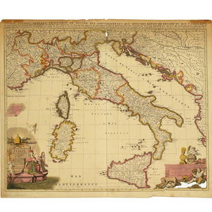
Sold2022Nicolas Sansom, map of Italy, 1701Nicolas Sansom, map of Italy, 1701, "L'Italie Divisee Suivant l'Estendue de Toutes ses Sourverainetes…", Pieter Schenk, Amsterdam, 1701, hand-colored copper plate engraving on laid paper, 20.25"See Sold Price
Sold2021De Fer Map of Italy, 1705[Europe, Italy] DE FER, Nicolas (1646-1720). Routes des Postes D'Italie... Engraved map with full original color and minor manuscript annotations. Paris, c. 1705. 19" x 27" sheet. This unusual, largeSee Sold Price
Sold2022(ITALY.) Gerard Mercator. Italia.(ITALY.) Gerard Mercator. Italia. Hand-colored double-page engraved map of Italy. 15½x19¼ inches sheet size, ample margins, French text on verso; center fold reinforced on verso, Duisberg, 1See Sold Price
Sold2020Grp: Maps of Greece and ItalyGroup of ten maps of Italy and Greece. Includes several maps from "Voyage in Italie," including Ravenna, Mantua; "Pianta della Citta di Pisa;" Map of Naples, Paris, 1705. "Cratere Maritimo, o Parte deSee Sold Price
Sold2022Italy.- Moll (Herman) A New Map of the Upper Part of Italy, engraved map with hand-colouring, [c.Italy.- Moll (Herman) A New Map of the Upper Part of Italy, containing ye Principality of Piedmont by ye Dutchies of Savoy, Milan, Parma, Mantua, Modena, Tuscany, the Dominions of ye Pope, &c. The RepSee Sold Price
Sold20201759 Geography 18 Maps ATLAS Africa Italy Asia America1759 Geography 18 Maps ATLAS Africa Italy Asia America California Island Buffier Known primarily for his contributions to philosophy, Claude Buffier, a 17th-century French Jesuit historian, publishedSee Sold Price
Sold2020Grp: 7 Maps of Sicily Italy 18th/19th c. Blair ClGroup of seven maps of Sicily. Includes Rev. John Blair, "Sicilia Antiqua quae at Sicania et Trinacria dicta;" Philipp Cluver, "Siciliae Antiquae Descriptio," Leiden, 1697, which features a stunninglySee Sold Price
Sold2020Grp: 5 Maps of Sicily Italy 18th/19th c. JaillotGroup of five 18th and 19th century maps of Sicily. Includes Hubert Jaillot , "La Sicile divisee en ses trois Provinces ou Valees, scavoir Valle Demona, Valle Di Noto, et Valle Di Mazara;" and GuillauSee Sold Price
Sold2021Italy 1762 by Homann HeirsTitle: Italy 1762 by Homann Heirs Date/Period: 1762 Materials: Copperplate engraved Size: 24 x 20 1/2" Description: A magnificent map of all of Italy. Shows Venetian territory’s in Dalmatia. CoSee Sold Price
Sold2020Grp: 7 Maps of Sicily and Sardinia ItalyGroup of seven maps of Sicily and Sardinia, Italy. Early 18th century Johann Homann (1664-1724) map "Regnorum Sicilia et Sardinia;" 18th century Homann Heirs map of Sicily "Regni & Insulae Siciliae TaSee Sold Price
Sold20191702 deFer Map of Spain, Portugal, France and Italy --Reserve Reduced! Title/Content of Map: 1702 deFer Map of Spain, Portugal, France and Italy -- Les Etats des Princes Armes au Suiet de la Succession de la Monarchie d'Espagne… Date: 1702, Paris CartoSee Sold Price
Sold2024Italian Faience Tile Celestial Map Wall MuralLarge Italian Faience Tile Celestial Map Wall Mural, 20th c., Rome, Italy, signed on tile "TANAGRA/ROMA", central Andreas Cellarius-style zodiac map, on an amber ground, embellished with raised gilt sSee Sold Price
Sold2022Purchase of Ocean Shore Lands and Sutro HeightsHeading: (California - San Francisco) Author: Title: Map of ocean shore lands, Sutro baths & museum and Sutro Heights Place Published: [San Francisco] Publisher:Publicity Committee, Board of SupervisSee Sold Price
Sold2017CYANOTYPE ARCHITECTURE ALBUM BY JEAN ALEXANDER 300+20TH C CYANOTYPE ARCHITECTURE NOTEBOOK: Early 20th century notebook including numerous cyanotype photographs illustrating the major landmarks and maps of European and Egyptian architecture (Italy, FraSee Sold Price
Sold2022A. Borsato Italy Large Porcelain Sculpture Reading the MapOrnately painted in fine detail, this scene features a group of early motorists attempting to find their way. Signed on the bottom. This lot has no reserve. Artist: Antonio Borsato Issued: 20th c. DimSee Sold Price
Sold2016T-O World Map.- Lucanus (Marcus Annaeus) Pharsalia,Lucanus (Marcus Annaeus) Pharsalia, manuscript on paper, [Northern Italy (possibly Padua), first half of the fifteenth century]. 294 x 217mm., I + 149 + I leaves (including defective leaves and 3 blanSee Sold Price
Sold20221818 Map I Stati Uniti Nell America SettentrionaleHistoric Maps 1818 Rare Map Titled "I Stati Uniti Nell' America Settentrionale" by A.B. Borghi, Florence, Italy Choice Crisp Near Mint 1818-Dated, Four-Sheet Copper-Engraved, Hand-Colored Outlines, MaSee Sold Price
Sold2018France.- Ortelius (Abraham) Gallia, detailed map ofFrance.- Ortelius (Abraham) Gallia, detailed map of France, with part of southern England, northern Italy, and includes Belgium and the Netherlands, a large title cartouche with two putto decorating tSee Sold Price
May 12Ararity AuctionsAntique Italian Grand Tour Bronze Putti Cupid holding a Dolphin Statue 'Amore con Delfino'.$55(2 bids)
6 days LeftHunt and Peck Estate Services, Inc.1694 Alexis-Hubert Jaillot Highly Detailed Map Of Italy$200(1 bid)
14 hrs LeftTrillium Antique Prints & Rare BooksDe Jode, Rare, pub. 1593 - Map of Part of Germany (Sveviae Utriusq cum Germicae tum Rheticae$100
6 days LeftHunt and Peck Estate Services, Inc.ANTONIO ZATTA (ITALIAN, 18TH CENTURY) MAP OF VIRGINIA$80(2 bids)
6 days LeftHunt and Peck Estate Services, Inc.ANTONIO ZATTA (ITALIAN, 18TH CENTURY) MAP OF VIRGINIA$70(1 bid)
14 hrs LeftTrillium Antique Prints & Rare BooksBlaeu?s Le Theatre du Monde? ? Volume 3 with 57 Fold Out Maps with Original Hand-coloring, 4 Smaller$1,000(1 bid)
14 hrs LeftTrillium Antique Prints & Rare BooksPtolemy & Magini, pub. 1620 - Map of the Americas$80(2 bids)
14 hrs LeftTrillium Antique Prints & Rare BooksPtolemy & Magini, pub. 1620 - Map of the World$50(1 bid)
14 hrs LeftTrillium Antique Prints & Rare BooksPtolemy & Magini, pub. 1620 - Map of the Ancient World with Africa, Europe, Asia$50
14 hrs LeftTrillium Antique Prints & Rare BooksPtolemy & Magini, pub. 1620 - Map of Taprobana, Island in Sumatra$50
4 days LeftJasper521846 Quin Map of the Mediterranean and Persia During the Rule of Cyrus -- Fourth period : B.C. 529.$55
May 12Schilb Antiquarian Rare Books1869 ATLAS 42 MAPS America Africa Australia GERMANY Switzerland Sydow RARE$155(4 bids)
May 12Schilb Antiquarian Rare Books1844 Harper Library United States Poland Navigation MAPS 14v Voyages RARE LOT$56(5 bids)


![De Fer Map of Italy, 1705: [Europe, Italy] DE FER, Nicolas (1646-1720). Routes des Postes D'Italie... Engraved map with full original color and minor manuscript annotations. Paris, c. 1705. 19" x 27" sheet. This unusual, large](https://p1.liveauctioneers.com/1968/216191/110783529_1_x.jpg?height=310&quality=70&version=1629990486)


![Purchase of Ocean Shore Lands and Sutro Heights: Heading: (California - San Francisco) Author: Title: Map of ocean shore lands, Sutro baths & museum and Sutro Heights Place Published: [San Francisco] Publisher:Publicity Committee, Board of Supervis](https://p1.liveauctioneers.com/642/270500/141583105_1_x.jpg?height=310&quality=70&version=1670438782)


![T-O World Map.- Lucanus (Marcus Annaeus) Pharsalia,: Lucanus (Marcus Annaeus) Pharsalia, manuscript on paper, [Northern Italy (possibly Padua), first half of the fifteenth century]. 294 x 217mm., I + 149 + I leaves (including defective leaves and 3 blan](https://p1.liveauctioneers.com/5458/94966/48431616_1_x.jpg?height=310&quality=70&version=1476369049)


