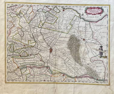
Sold2023The Netherlands Map. The region Around the city of Utrecht. 1660?s by W. BlaeuTitle: The Netherlands Map. The region Around the city of Utrecht. 1660?s by W. Blaeu Date/Period: 1660?s Materials: Hand colored copper plate engraved Size: 22 x 19 1/2'' Netherlands regional map cenSee Sold Price
Sold20172 early maps, Chili & Auriacus Princip, by Ortelius.2 Antique Hand-Colored Map Prints, "Royaume de Chili", a miniature map of Chili, South America ; and "Auriacus Principatus" ( by Ortelius), showing the region around the Roman city of Orange in southeSee Sold Price
Sold2018Bellin: Antique Map of Ancient Mexico City Region, 1760Map: Karte von dem See von Mexico Cartographer: Bellin / Arkstee&Merkus Place & Date: Leipzig / 1760 Size: 5 7/8" x 7 7/8" Condition: b&w; overall age toning and light browning Bellin's detailed map oSee Sold Price
2022Blaeu, Johannes (Netherlands, 1596-1673) "The New World Map" Double Hemisphere World Map C. 1664Nova et Accuratissima Totius Terrarum Orbis Tabula Translated "The New World Map", Hand Colored w/ Elaborately Decorated Spandrels.   Sight View 16" x 21-1/2", Overall View 21" x 25-1/2"See Sold Price
Sold2024BLAEU 17TH C. MAP OF THE SARLAT REGION OF FRANCEHand-colored engraving with centerfold and text verso. Full description on dealers label. Dated to circa 1642. Matted. Dimensions: L 27" x W 22" Condition: Paper with light age toning. Offset from texSee Sold Price
Sold2022DOMINIO FIORENTINO & JOHANNES BLAEU 1646 MAPCopper engraving, depicting Florence and the Cities in the Region of Tuscany, from Willaem Janszoon Blaeu, Atlas Mayor, containing a title cartouche the right, incorporating a monarch, a knight, lionSee Sold Price
Sold2022The Netherlands. 1st French Empire Belgium w/ 13 Départements. THOMSON 1830 mapTITLE/CONTENT OF MAP: 'Belgium or the Netherlands' Belgium shown under the First French Empire, with 13 Départements; although Napoleon's rule over the region had ended with his defeat at WaterloSee Sold Price
Sold2019Two Maps by Willem Janszoon Blaeu (1571-1638),Two Maps by Willem Janszoon Blaeu (1571-1638), "Virginiae partis australis et Florida partis orientalis," 1640, hand colored, H. - 15 in., W. - 20 in.; together with India Quae Orientalis Diktur et InSee Sold Price
Sold2019Two Maps by Willem Janszoon Blaeu (1571-1638,Two Maps by Willem Janszoon Blaeu (1571-1638, Amsterdam), "Noramndia Ducatus (with History on reverse)," 1640; together with "Languedoc," 1640, hand colored, Languedoc- H. - 19 in., W. 24 in., DucatusSee Sold Price
Sold2019Two Maps by Willem Janszoon Blaeu (1571-1638,Two Maps by Willem Janszoon Blaeu (1571-1638, Amsterdam), "Burgundia Ducatus," 1640; together with "Champagne Latine Campania Comitatus," 1640, hand colored, Champagne- H. - 16 in., W. - 23 in., BurguSee Sold Price
Sold2024Antique map of Virginia - Florida by Blaeu W. 1642-43Virginia and Florida. "Virginiae partis australis, et Floridae partis orientalis, interjacentiumque regionum nova descriptio". Orig. copperplate engraving, W. J. Blaeu, published by C. and J. Blaeu inSee Sold Price
Sold202417C. Willem Blaeu Map of MexicoWillem Blaeu Netherlands 1571-1638 Map of Mexico titled "Nova Hispania et Nova Galicia" in a colored cartouche by Willem Blaeu, featuring a glass back to showcase the atlas pages. Lithograph on paper,See Sold Price
Sold2019LARGE 1912 MAP, CITY OF AUSTIN, TEXAS, 73" x 44"Large faded unframed map, "Tobins Updated Map of the City of Austin, Mar. 1912", showing downtown blocks, the capitol building, East Avenue that became I35 and neighborhoods, 73.75"h, 44.5"w Start PriSee Sold Price
Sold2018Old Master Portrait Man W/ Beard Lievens ?TYPE:Art SUB TYPE:Painting REGION:Europe SUB REGION:Netherlands MEDIUM:Oil SGD/UNS: TITLE:Old Master Portrait Man W/ Beard Lievens ? CATALOG NOTES:A fine large original oil portrait featuring a gentleSee Sold Price
Sold2022SAN DIEGO CITY COLLEGE W/ LOGO PORCELAIN SIGNSST SIGN HAS VERY GOOD COLOR AND GLOSS, HAS LIGHT WEAR IN THE FIELD, HAS TINY CHIPS AROUND THE PERIMETER, 24"X48", RATED 9. TAC #040268See Sold Price
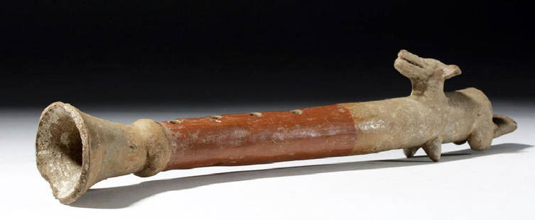
Sold2017Rare Aztec Polychrome Pottery Flute w/ CoyotePre-Columbian, Mexico City region, Aztec Empire, ca. 1300 to 1500 CE. A rare and beautiful musical instrument. With four finger holes, a narrow blowing hole, and a flared, conical opening end, this inSee Sold Price
Sold20231642 HISTORY of ULTRECHT NETHERLANDS antique VELLUM BOUND FOLIO in LATIN w/ MAPDE EPISCOPIS ULTRAIECTINIS, RECOGNITI ET NOTIS HISTORICIS ILLUSTRATI AB ARN. BUCHELIO BATAVO I.C. ACCEDUNT LAMB. HORTENSII MONTFORTII SECESSIONUM ULTRAIECTINARUM LIBRI, ET SIFFRIDI PETRI FRISII APPENDSee Sold Price
Sold2018Blaeu: Antique Map of Europe, 1650Title/Content of Map: Highly decorative Map by Blaeu Date Printed: c1650 Cartographer: W. Blaeu Material/Medium: Paper Size: 19" x 24" Hand colored engraved Map. French text on Verso. Magnificent examSee Sold Price
Sold2018Blaeu: Antique Map of Anglo Saxon Britain, 1645Title/Content of Map: Map of Anglo Saxon Britian Date Printed: 1645 Cartographer: W. Blaeu Material/Medium: Paper Size: 19" x 23" Anglo Saxon Britian. Hand colored copperplate engraved. Latin text onSee Sold Price
Sold2019Gerard Van Keulen (1654-1715, Amsterdam), "Pas KaartGerard Van Keulen (1654-1715, Amsterdam), "Pas Kaart Von West Indien," 1690, hand colored engraved map, H. - 21 in., W. - 25 in.See Sold Price
Sold2022Niek Van der Plas (Netherlands, 1954-), "Beach Scene," 21st c., oil on board, signed lower right,Niek Van der Plas (Netherlands, 1954-), "Beach Scene," 21st c., oil on board, signed lower right, with a branded signature en verso, presented in a gilt frame, H.- 4 1/2 in., W.- 6 1/2 in., Frame H.-See Sold Price
Sold2022French Louis Philippe Carved Oak Gilt Overmantel Mirror, 19th c., the arched cove molded frameFrench Louis Philippe Carved Oak Gilt Overmantel Mirror, 19th c., the arched cove molded frame around a beaded liner and an arched mirror plate, H.- 56 in., W.- 43 in., D.- 2 1/8 in. Provenance: fromSee Sold Price
Sold2019Herman Moll 1654-1732), "A New And Correct Map of theHerman Moll 1654-1732), "A New And Correct Map of the World," 1710, hand colored, H. - 22 in., W. - 38 in.See Sold Price
Sold2019Two Copies of Emanuel Bowen (1693-1767), "A New Map ofTwo Copies of Emanuel Bowen (1693-1767), "A New Map of Georgia, Florida, Louisiana, Carolina," 1748, H.- 15 3/4 in., W.- 20 in.See Sold Price
4 days LeftJasper521792 Elwe Map of Southern Netherlands to Belgium to Northern France -- Carte Nouvelle des Pais Bas$80
7 days LeftCrescent City Auction GalleryEighty-Nine Piece Set of French Limoges Porcelain Dinnerware, 20th c., Dinner- H.- 1 in., Dia.- 9 1/$250
May 11Crescent City Auction GalleryWilliam H. Williams (1817-1886), New Orleans "Map of the Sixth District and Carrollton," 1871, H.-$650
May 11Crescent City Auction GalleryFrench Louis Philippe Gilt and Gesso Overmantel Mirror, 19th c., H.- 37 1/2 in., W.- 26 3/4 in., D.-$425
7 days LeftCrescent City Auction GalleryLouis XVI Style Gilt and Gesso Overmantel Trumeau Mirror, early 20th c., H.- 67 in., W.- 34 in.$325
7 days LeftCrescent City Auction GalleryFrench Louis Philippe Period Gilt and Gesso Overmantel Mirror, 19th c., H.- 50 in., W.- 36 in.$425
May 11Crescent City Auction GalleryLarge Louis XV Style Carved Giltwood and Gesso Overmantel Mirror, 20th/21st c., H.- 92 in, W.- 52$600(1 bid)
May 11Crescent City Auction GalleryDiminutive Antique Carved Rosewood Desk, 20th c., H.- 31 1/2 in., W.- 42 1/4 in., D.- 20 1/4 in.$325
May 11Crescent City Auction GalleryLarge Louis XV Style Carved Giltwood and Gesso Overmantel Mirror, 20th/21st c., H.- 92 in., W.- 52$600
May 11Crescent City Auction GalleryFrench Louis Philippe Carved Walnut Mirror, mid 19th c., H.- 50 1/2 in., W.- 39 in.$325
May 11Crescent City Auction GalleryFrench Provincial Carved Walnut Tallcase Clock, 19th c., H.- 99 in., W.- 24 in., D.- 10 1/4 in.$325
May 19Rich Penn AuctionsTobacco Tin, Chicago Cubs Chewing Tobacco, 20 cent plugs, colorful litho on tin from Rock City$50(1 bid)