Sold2016Map of Florida & Keys, 1892Original engraving of Florida with Key, Lake Orange and Volusa inset published by Rand McNally, 1892. Unframed. Light toning. Dimensions: 27.75" L x 21.5" H No Reserve Buyer pays shipping. This item sSee Sold Price
Sold2023(2 Pc) 19th Century Florida MapsDESCRIPTION: Two antique maps of Florida: (1) 1863 "Johnson's Florida" map published by A.J. Johnson featuring inset map of the Florida Keys. Partial "Geographical Index of Ready Reference" on reverseSee Sold Price
Sold2017Colton: Antique Map of Florida and Florida Keys, 1855Florida (with inset of Florida Keys). J. H. Colton, 1855. From the 1856 second edition of Colton’s Atlas of the World. Rich color with good impression. Clean. Extra light edge toning at side marginsSee Sold Price
Sold2023Johnson's Cuba, Jamaica & Porto Rico. Puerto Rico. Bahamas Florida Keys 1861 mapTitle: Johnson's Cuba, Jamaica & Porto Rico. Puerto Rico. Bahamas Florida Keys 1861 map Description: Johnson's Cuba, Jamaica and Porto Rico' by Alvin Jewett Johnson (1861). Large, decorative hand coloSee Sold Price
Sold2023Florida Keys retro Map scarf scarves coastal beach Fun gift turquoise Key West Key Largo Marathoexcellent conditionSee Sold Price
Sold2023L'Isle de Cuba, the southern Bahamas and the Florida Keys. BONNE 1780 mapTitle: "L'Isle de Cuba", the southern Bahamas and the Florida Keys. BONNE 1780 map Description: L'Isle de Cuba' by Rigobert Bonne (1780). Antique copperplate engraved map, 23.0 x 35.0cm, 9 x 13.75 incSee Sold Price
Sold2024DOC Map, Florida Bay, United StatesA map of the Florida Bay and Key Largo with their surrounding areas on one side. On the reverse side is a map of Miami and Biscayne Bay along with information of that time. Publishing stamp by "U.S DeSee Sold Price
Sold2023USC&GS Map, Fowey Rocks to American Shoal, Florida KeysA color map showing the land and sea area of Fowey Rocks to American Shoal. Publishing stamp by "The U.S Coast and Geodetic Survey" located on bottom. Issued: 1940 Dimensions: 38.5"L x 34"W MaSee Sold Price
Sold2023USC&GS Map, Fowey Rocks to American Shoal, Florida KeysA color map showing the land and sea area of Fowey Rocks to American Shoal. Publishing stamp by "The U.S Coast and Geodetic Survey" located on bottom. Issued: 1940 Dimensions: 38.5"L x 34"W MaSee Sold Price
Sold2024USC&GS Map, Elliot Key to Florida Bay, Intercoastal WaterwayTitle "USC&GS Map, Elliot Key to Florida Bay, Florida Intercoastal Waterway" Depicts a color map of the Intracoastal Waterway from Key Elliot to the Florida Bay. Publishing stamp by "The U.S Coast andSee Sold Price
Sold2023USC&GS Map, Sombrero Key to Sand Key, Florida Gulf CoastA colored map depicting the area of the Gulf Coast from the Sombrero Key to the Sand Key. Publishing stamp by "The U.S Coast and Geodetic Survey" located on bottom. Issued: 1940 Dimensions: 43"L x 35"See Sold Price
Sold2023USC&GS Map, Sombrero Key to Sand Key, Florida Gulf CoastA color map depicting the land and sea area of the Sombrero Key to the Sand Key. Publishing stamp by "The U.S Coast and Geodetic Survey" located on bottom. Issued: 1954 Dimensions: 43.5"L x 36See Sold Price
Sold2023USC&GS Map, Alligator Reef to Sombrero Key, FL Gulf CoastTitle "USC&GS Map, Alligator Reef to Sombrero Key, Florida Gulf Coast". A color map depicting the land and sea area of Alligator Reef to the Sombrero Key. Publishing stamp by "The U.S Coast and GeodetSee Sold Price
Sold2021Nice map of SE coast of U. S. (Colton)Clean map of the southeast coast of the United States, with good detail. Shows railroad lines, towns, rivers, lakes, swamps, islands and coastal features. Inset of the Florida Keys. Full, original hanSee Sold Price
Sold20211875 h/c map of Florida in fine conditionDetailed map of Florida showing township surveys, forts, canals, swamps, counties, cities, roads, railroads, inland waters, etc. with inset Plan of Florida Keys. Shows Olustee in the north near Lake CSee Sold Price
20231859 Map of Florida by ColtonTitle: 1859 Map of Florida by Colton Date/Period: 1859 Materials: Steel engraved Size: 17 1/2 x 14 1/2” Florida with Florida keys in the insert. From before the civil war. By J. H. Colton & G. WSee Sold Price
Sold20201893 1ed FLORIDA East Coast Jacksonville Railroad1893 1ed FLORIDA East Coast Jacksonville Railroad Illustrated Photogravure MAP Helen Ingram provided the text for this early first edition brochure of Florida by Jacksonville, St. Augustine and the InSee Sold Price
Sold20231859 Map of Florida by ColtonTitle: 1859 Map of Florida by Colton1859 Materials: Steel engraved Size: 17 1/2 x 14 1/2” Florida with Florida keys in the insert. From before the civil war. By J. H. Colton & G. W. Colton. From "GeSee Sold Price
Sold2022Scarce Civil War era map of Florida with great detail,Great map of Florida showing the entire state (includes small inset of Florida Keys). Shows state shortly after the outbreak of the Civil War. Notes proposed course of a canal route from Tampa to theSee Sold Price
Sold2023Civil War era map of Florida, 1863Lovely early map of Florida, vividly hand colored by county, with a large inset of the Florida Keys. Shows towns, railroads, villages, post offices, forts, etc. Only five counties shown in the southerSee Sold Price
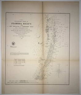
Sold2020(F No.4) Preliminary Chart of Florida Reefs from KeyTitle/Content of Map: (F No.4) Preliminary Chart of Florida Reefs from Key Biscayne to Carysfort Reef... Publication Date: 1855 Cartographer: Totten, Jas./I. Hull Adams Publisher: U.S. Coast Survey DeSee Sold Price
Sold2024USC&GS Map, Barnes Sound to Key West, Intercoastal WaterwayTitle "USC&GS Map, Barnes Sound to Key West, Florida Intercoastal Waterway". Depicts a color map of the Intracoastal Waterway from Barnes Sound to Key West. Publishing stamp by "The U.S Coast and GeodSee Sold Price
Sold20211892 Florida MapAuthor: Cram Title: 1892 Florida Map Medium: Ink on Paper Dimensions: 11"X13.5" Map of Florida dated 1892. Printed and published by George Cram in Chicago. Part of his Family Atlas. Key lower left. InSee Sold Price
Sold20201902 Map of FloridaAuthor: Century Title: 1902 Map of Florida Medium: Ink on paper Dimensions: 12"X16" Map of Florida dated 1902. Published by The Century Company in New York. Double folio map. Key upper right. Insets oSee Sold Price
6 days LeftRail & Road AuctionsEleven Army Corps of Engineers Port Series No. 1 Through No. 8 Books with Fold Out Maps$35(2 bids)
May 12Schilb Antiquarian Rare Books1883 FLORIDA for Tourists & Settlers Illustrated Fort Barrancas MAP Fine BINDING$90(5 bids)
May 14Akiba Galleries(2 Pc) Allain Manesson Mallet Description De L'Univers 2 Vol. German Translation$200(1 bid)
5 days LeftJasper52West Indies. Caribbean islands Antilles Gulf of Mexico Florida. THOMSON 1830 map$150
5 days LeftHunt and Peck Estate Services, Inc.1794 Laurie & Whittle after Thomas Jefferys Map Of The United States Of America$340(1 bid)
5 days LeftRail & Road AuctionsSix Southeastern Railroad Annual Passes - 1876 Pioneer Steamboat Line, 1892 Atlantic Coast Line, and$50
5 days LeftHunt and Peck Estate Services, Inc.1804 CF Volney "View of the Climate and Soil of the United States of America"$50
May 11Trillium Antique Prints & Rare BooksCatesby, Folio - Kingfisher with Narrow Leaved Candleberry Myrtle. 1-69$200
7 hrs LeftTrillium Antique Prints & Rare BooksCatesby, Folio - Larger Red crested Woodpecker with Live Oak. 1-17$200
May 11Trillium Antique Prints & Rare BooksCatesby, Folio - Great Laurel & Narrow Leaved Laurel. Sup-17$200
7 hrs LeftTrillium Antique Prints & Rare BooksCatesby, Folio - Blackcap Flycatcher on Yellow Jessamy. 1-53$200