Sold2021MAP OF DARIEN CONNECTICUTDimensions: (Frame) H 26" x W 22" (Sight) H 18.5" x W 15" Condition: Wear consistent with age and display including light age toning to paper.See Sold Price
Sold2023MAP, Connecticut, ReidConnecticut. John Reid, Connecticut from the Best Authorities, from Winterbotham's History of America, 1796 (circa). Black & White. This early and uncommon map of Connecticut was engraved by BenjaminSee Sold Price
Sold2017Bradford: Antique Map Connecticut & Rhode Island, 1835Title/Content of Map: Connecticut & Rhode Island Date Printed: 1835 Cartographer: T. G. Bradford Material/Medium: Paper Size: 9 1/2" x13" A Comprehensive Atlas Geographical, Historical & Commercial. PSee Sold Price
Sold2018Bradford: Antique Map of Connecticut, 1838Title/Content of Map: Connecticut by Bradford Date Printed: 1838 Cartographer: Thomas G. Bradford Size: 14" x17" Material/Medium: Paper Provenance: New York A General Atlas of the World with a separatSee Sold Price
Sold2018Tanner: Antique Map of Connecticut, 1843Title/Content of Map: Connecticut by Tanner Date Printed: 1843 Cartographer: based on the work of H.C. Tanner Size: 17" x 14" Material/Medium: Paper Provenance: New York Hand colored engraved Map. FroSee Sold Price
Sold2021Connecticut, 1846, with Hartford & New Haven InsetsTitle/Content of Map: Connecticut, 1846, with Hartford & New Haven Insets Date Printed: 1846, Hildburghausen Cartographer: Joseph Meyer/Bibliographisches Instituts. Size: 14 1/2" 11 3/4" The beautifulSee Sold Price
Sold2018Colton: Antique Map of Connecticut, 1859Title/Content of Map: Connecticut by Colton Date Printed: 1859 Cartographer: H.J. Colton Material/Medium: Paper Size: 17 1/2" x 15" Hand colored,engraved. Published in New York in 'Colton's General AtSee Sold Price
Sold2017Colton: Antique Map of Connecticut, 1861Title/Content of Map: Connecticut by Colton Date Printed: 1861 Cartographer: J.H. Colton Material/Medium: Paper Size: 17 1/3" x 14" Hand colored steel engraved Map from 'Colton's General Atlas'. PubliSee Sold Price
Sold2016Rand, McNally & Co: Connecticut, Rhode Island, 1898Map: Connecticut, Rhode Island Size: 21 x 15 inchesMaker: Rand, McNally & Co Date: 1898From: New Standard Atlas of the World No Reserve: This lot starts at $1 and has no reserve as a courtesy so thatSee Sold Price
Sold2018Two Maps of Connecticut TownsTown of Goshen 32" x 41" dated 1853 Town of Sharon 36" x 43"See Sold Price
Sold2021Two Framed West Hartford, Connecticut Maps with handTwo Framed West Hartford, Connecticut Mapswith hand coloring by L.J. Richards of West Hartford, Connecticutcirca 1890's24" x 34" framedSee Sold Price
Sold2023Scarce 1846/48 map of Connecticut by MitchellGreat and authentic map of Connecticut from the 1848 New Universal Atlas by S. Augustus Mitchell. Early Mitchell atlas maps are becoming harder and harder to find—they rarely appear at auction. TheySee Sold Price
2022Scarce 1846/48 map of Connecticut by MitchellGreat and authentic map of Connecticut from the 1848 New Universal Atlas by S. Augustus Mitchell. Early Mitchell atlas maps are becoming harder and harder to find—they rarely appear at auction.See Sold Price
Sold2016(3) 19th c. hand colored maps of ConnecticutGrouping of three circa 1867 hand colored maps and one black and white advertisement from the "Atlas of New York and Vicinity" by Beers, Ellis & Soule, the drawings based on land surveys performed undSee Sold Price
Sold2020Lot Antique Maps Of Connecticut State & TownsLot of Antique Maps Of Connecticut State & Towns. Includes 10 maps from 19th century. Largest map measures 23 inches in height by 20 inches in width.See Sold Price
Sold2015(3) 19th c. hand colored maps of ConnecticutGrouping of three circa 1867 hand colored maps from the "Atlas of New York and Vicinity" by Beers, Ellis & Soule, the drawings based on land surveys performed under the direction of F.W. Beers, includSee Sold Price
Sold2023EARLY CONNECTICUT MAPHand drawn and colored; "Connecticut and Parts Adjacent", "drawn by Miss. Elizabeth L. Tredwell" "Christ Church Academy 1820", several edge tears; 23" x 30", F-GSee Sold Price
Sold20221796 Reid Map of Connecticut -- Connecticut from the Best AuthoritiesTitle: 1796 Reid Map of Connecticut -- Connecticut from the Best Authorities Cartographer: J Reid Year/Place: 1796 Dimensions: 13.9 X 17.1 in. Description: This is an excellent, early and uncommon mapSee Sold Price
Sold20161797 AMOS DOOLITTLE CORRECT MAP OF CONNECTICUTEngraved for Dr. Trumbull's History of Connecticut. 14 x 16 1/2 inches.See Sold Price
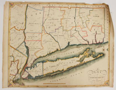
Sold2023Map of Connecticut And Rhode Island 1780This early map is titled 'A New and accurate Map of Connecticut and Rhode Island. from the best Authorities' published in the Universal Magazine in 1780. The map features Long Island Sound and NarragaSee Sold Price
Sold2020Amos Doolittle Map of ConnecticutAmos Doolittle Map of Connecticut. Map: H 12", W 14-1/2" approx; frame size: H 20-1/4",. W 22-1/2". Professionally framed. Collection of Laura Mitler. Please see link for high res photos: https://www.See Sold Price
Sold2023Antique Map of Connecticut and Rhode IslandEngraved print map of Connecticut and Rhode Island. Highly detailed revolutionary war era map with towns, roads, rivers, islands, bays and more. Issued: 1776 Dimensions: 10"W x 8"HSee Sold Price
5 days LeftTrillium Antique Prints & Rare BooksCarey, pub. 1805 - 3 Maps of the States of Massachusetts, Connecticut, & New Jersey$85(2 bids)
2 days LeftJasper521867 Beers Map of New York City Area -- Map of New York and Vicinity Accompanying "Atlas of New York$200
6 days LeftBrandywine Valley AuctionsVintage American School New York Artist Roger Selchow Abstract Mid Century Modern Watercolor Signed$50