Sold2015A FRAMED FLEMISH COPPER PLATE CARTOGRAPHIC ENGRAVINGA FRAMED FLEMISH COPPER PLATE CARTOGRAPHIC ENGRAVING AFTER ABRAHAM ORTELIUS (1527-1598), "AENEAE TROJANI NAVIGATIO AD VIRGILII SEX PRIORES AENEIDOS," ANTWERP, 1603, an example of an unusual "literary"See Sold Price
Sold2015A FRAMED FRENCH COPPER PLATE CARTOGRAPHIC ENGRAVINGA FRAMED FRENCH COPPER PLATE CARTOGRAPHIC ENGRAVING AFTER JACQUES-NICOLAS BELLIN (1703-1772), "PLAN DE LA FORTERESSE DE COYLAN," PARIS, 1757, prepared for and issued by Abbé Prévost (French 1697-176See Sold Price
Sold2016A FRAMED BELGIQUE TWO-PART HAND COLORED COPPER PLATEA FRAMED BELGIQUE TWO-PART HAND COLORED COPPER PLATE CARTOGRAPHIC ENGRAVING OF THE CALAIS/BOULOGNE AND VERMANDOIS REGIONS OF FRANCE AFTER THEATRUM ORBIS TERRARUM BY ABARAHAM ORTELIUS (Flemish 1527-159See Sold Price
Sold2015A FRAMED BRITISH HAND COLORED COPPER PLATE CARTOGRAPHICA FRAMED BRITISH HAND COLORED COPPER PLATE CARTOGRAPHIC ENGRAVING OF THE BRITISH ISLES, AFTER ROBERT MORDEN (British 1650-1703) "BRITANNIA, OR A CHOROGRAPHICAL DESCRIPTION OF GREAT BRITAIN AND IRELANDSee Sold Price
Sold2020Matthaus Seutter, pair allegorical engravingsMatthaus Seutter, pair allegorical engravings, Matthaus Seutter (German, 1678-1757), "STATUA REGUM EUROPAEORUM P.C. N. NOMINA CONTINENS." and "ICON SYNOPTICA SAC. ROM. IMP. ELECTORUM. DUCUM. PRINCIPUMSee Sold Price
Sold2017George Matthaus Seutter, Map of RomeColored engraving. George Matthaus Seutter (1678-1757). Approx. 23" H x 26" W framed. (6090)See Sold Price
Sold2019FOUR VIEWS OF STETTIN AND POMERANIA German, Dutch i.a.,FOUR VIEWS OF STETTIN AND POMERANIA German, Dutch i.a., i.a. Matthäus Merian, Johannes Janssonius, Matthäus Seutter, 17th/18th century and later Engraving, partly coloured, on different papeSee Sold Price
Sold2023Matthaus Seutter Map of North AmericaColored engraving map of eastern North America by Matthaus Seutter (1678-1757). Framed; framing partially obscures borders. Map covers Eastern and Central United States and Canada, Northern Mexico, anSee Sold Price
Sold2018MATTHAUS SEUTTER (LUXEMBOURG C. 1730) MAPMap of fort and city of Luxembourg. Hand colored engraving. Dimensions: (Frame) H 20.75" x W 24.25", (Sight) H 19.75" x W 23" Condition: Foxing. Age toning.See Sold Price
Sold202118TH C. ENGRAVING, SPHAERAE ARTIFICIALES , SEUTTERSphaerae Artificiales Synoptica Idea delineatae et propositae published Matthaus Seutter (1687-1757), Augsburg, Germany, 1730 colored copper engraving, impression 19.25 by 22.5 in; sheeSee Sold Price
Sold2017Dutch 'American Septentrionalis' map, circa 1647Johannes Janssonius, known as Jan Jansson (Dutch, 1588-1664), hand colored copper engraving titled 'America Septentrionalis,' executed in Amsterdam circa 1647, depicting a cartographic amalgamation ofSee Sold Price
Sold2024Antique Map - Colossus Monarchic. Statua Danielis SEUTTER Matthaus 1707One from the set of four famous cartographic curiosities by Seutter. The series of impressive copper engravings intended to serve as a serious instructional aid by illustrating geographical terms., puSee Sold Price
Sold2024Antique Map - Colossus Monarchic. Statua Danielis SEUTTER, Matthaus 1707One from the set of four famous cartographic curiosities by Seutter. The series of impressive copper engravings intended to serve as a serious instructional aid by illustrating geographical terms.See Sold Price
Sold20201684 Pas kaart Van de Caribes Tusschen I. Barbados en IThis is an authentic antique map of the Lesser Antilles by Johannes Van Keulen. The map was published in Amsterdam in the year 1684. This is an impressive hand colored example of Van Keulen’s nSee Sold Price
Sold20211613 America sive India Nova ad magnae GerardiBy: Michael MercatorDate: 1613 / DuisbergDimensions: 16 x 19.5 inches (40.7 x 49.5 cm)This is an authentic antique map of the Western Hemisphere by Michael Mercator. The map is based on Rumold MercatoSee Sold Price
Sold20211627 Carte de l'Amerique Corrigee, et Augmentee, dessusBy: Bertius/TavernierDate: 1627 (circa)Dimensions: 20 x 15.25 inches (50.75 x 38.5 cm)According to Burden, "This rare map is one of a set of the four known continents that Melchior Tavernier had engraSee Sold Price
Sold2020The Western Coast of Louisiana... Coast of New LeonA first state example of the earliest map to focus on the coast of Texas, recognized as the New Kingdom of Leon” This landmark map of the Texas coast presents the area as the Kingdom of Leon,” andSee Sold Price
Sold20211794 A New and General Map of the Middle DominionsBy: Lewis Evans published by Laurie & Whittle Date: 1794 (Published) London Dimensions: 18.75 x 25.6 inches (47.6 x 65.02 cm) This is a fine old color example of the Laurie & Whittle edition of LewisSee Sold Price
Sold20211661/1707 Corporum Coelestium MagnitudinesBy: Andreas Cellarius - pub. by Valk & SchenkDate: 1661 / 1708 (published) AmsterdamDimensions: 16 x 19.5 inches (40.5 x 45.5 cm)Beautiful celestial map by the famous cosmographer Andreas Cellarius, sSee Sold Price
Sold20211658 Nova et Accurata Iaponiae, Terrae Esonis, acBy: Johannes JanssonDate: 1658 (published) AmsterdamDimensions: 18 x 22 inches (45.7 x 55.9 cm)This is an authentic antique map of Japan and Korea, showing portions of China, Landt van Eso and CompagnSee Sold Price
Sold2020Asia IV Tab.This is an early and scarce map of present day Saudi Arabia, Qatar, United Arab Emirates, Yemen, and Oman. Only the first (1578) and second (1584) editions of the atlas were published during Gerard MeSee Sold Price
Sold20211584 Asia VI Tab.By: Mercator / PtolemyDate: 1584 (circa) Amsterdam.Dimensions: 19 x 13 inches (48.25 x 33 cm)This is an early and scarce map of present day Saudi Arabia, Qatar, United Arab Emirates, Yemen, and Oman.See Sold Price
Sold20211588 Africae Tabula NovaBy: Abraham OrteliusDate: 1588 (published) AntwerpDimensions: 14.5 x 18 inches (36.83 x 45.72 cm)This is an authentic antique map of Africa was published by Abraham Ortellius in 1588. It was taken froSee Sold Price
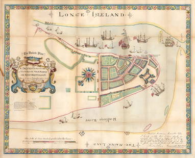
Sold20211664 / 1859 "The Duke's Plan" A Description ofBy: original cartographer unknown / Reissue by: David Thomas Valentine / Engraved by: George HaywardDate: original manuscript 1664 / Reissue 1859 (Published) New YorkDimensions: 21.75 x 27.25 inches (See Sold Price
Jun 08Leon GalleryVincenzo Maria Coronelli (1650-1718) - Uniform set of two large globe gores of the Far East₱400,000
5 days LeftJasper521630 MAP OF LEDEN BELGIUM LIEGE copper engraving ANTIQUE Mercator-Hondius Atlas$50
1 day LeftTrillium Antique Prints & Rare BooksPtolemy & Magini, pub. 1620 - 3 Maps of Italy: Rome, Naples, Lombardia$55(2 bids)
1 day LeftTrillium Antique Prints & Rare BooksPtolemy & Magini, pub. 1620 - 4 Maps of European Countries: Spain, Portugal, France, & Greece$50
1 day LeftBasel Auction HouseHand colored engraving by Thomas Rowlandson (London 1756-1827) Titled Moderne Antiques$500
5 days LeftCedarburg Auction & Appraisals LLCT. Brewer large steel engraving Amiens Cathedral$50(3 bids)