Sold2023Inaugurataion of Abraham Lincoln Photo PrintCreated in the early 1990's, sepia-tone photo print of Abraham Lincoln's Inauguration on March 4, 1861. 8" X 10" printed on heavy cardstock with double mat boards to make the overall size 11" X 14".See Sold Price
Sold2023Inaugurataion of Abraham Lincoln Photo PrintCreated in the early 1990's, sepia-tone photo print of Abraham Lincoln's Inauguration on March 4, 1861. 8" X 10" printed on heavy cardstock with double mat boards to make the overall size 11" X 14".See Sold Price
Sold20211928 Santa Fe AT&SF Time Tables, Grand Canyon LineThis wonderful Santa Fe brochure time table is from March 4, 1928. It has two great maps for Santa Fe routes and beautiful graphics Measures 4" x 9"See Sold Price
Sold20191861 & 1855 Maps of Boston(1) 1861 map by W. C. Sharp, Boston. Advertising to reverse. Fold crease separations, some with tape repairs. 10 1/2" x 11 1/4" approx. (2) 1855 map engraved by G. W. Boynton. Very good condition; ageSee Sold Price
Sold20191861 Johnson Map of Central America -- Johnson'sTitle/Content of Map: 1861 Johnson Map of Central America -- Johnson's Central America Date: 1861, New York Cartographer: Johnson and Ward Size: 12.4 X 15.6 in. This is a superb, large map of CentralSee Sold Price
Sold2019Graf: Large South America Continent Map, 1861Cartographer: Geographisches Institut. / Graf Place/Date: Weimar / 1857/1861 Size: 17 3/4" x 22" Condition: wash color; light overall age toning and a minor stain on the right edge of the wide margin,See Sold Price
Sold2017Colton: Antique Map of Boston, 1861Title/Content of Map: Boston by Colton Date Printed: 1861 Cartographer: J.H. Colton Material/Medium: Paper Size: 14" x 17 1/4" Hand colored, steel engraved. From Colton's 'General Atlas'. Published inSee Sold Price
Sold2017Colton: Antique Map of Japan, 1861Map: Japan Date Printed: 1861 Cartographer: J. H. Colton Material/Medium: Paper Size: Approx 17 1/2" x 14 1/4" Condition: Excellent Hand colored, steel engraved. From Colton's General Atlas New York.See Sold Price
Sold2017Colton: Antique Map of Russia, 1861Title/Content of Map: Russia by Colton Date Printed: 1861 Cartographer: J. H. Colton Material/Medium: Paper Size: 13 3/4" x 17 1/3" Hand colored. Steel engraved. From 'Colton's General Atlas.' PublishSee Sold Price
Sold202219th c. Hand Drawn Map19th c. hand drawn map. Marked "A / MAP / OF THE / UNITED STATES / DRAWN / BY / LEONARD ATWATER / MARCH 1824". Sight 15 3/4" x 19 1/2", overall 19" x 22 1/2".See Sold Price
Sold2017Colton: Antique Map of India Hindostan, 1861Title/Content of Map: India Hindostan Date Printed: 1861 Cartographer: J.H. Colton Material/Medium: Paper Size: 14" x 17 1/4" Hand colored, steel engraved. From Colton's 'General Atlas'. Published inSee Sold Price
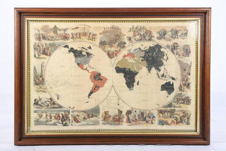
Sold2021PICTORIAL MISSIONARY MAP OF THE WORLDHand colored lithograph featuring map of the globe with vignettes of the introduction of Christianity in various cultures of the world, published in 1861, sight size 18 3/4 x 28 3/4 inches, set in oriSee Sold Price
Sold2017Colton: Antique Map of Lakes and Islands, 1861Title/Content of Map: Lakes and Islands Date Printed: 1861 Cartographer: J. H. Colton Material/Medium: Paper Size: 17 1/4" X 13" Condition: Excellent Hand colored, steel engraved. From 'Colton's GenerSee Sold Price
Sold2017Colton: Antique Map of Netherlands and Belgium, 1861Title/Content of Map: Colton's Netherlands and Belgium Date Printed: 1861 Cartographer: J. H. Colton Material/Medium: Paper Size: 17 1/2" x 13 3/4" Hand colored. Steel engraved. From 'Colton's GeneralSee Sold Price
Sold2019Two Copies of Johnson & Ward, "New Military Map of theTwo Copies of Johnson & Ward, "New Military Map of the United States," 1861, hand colored, H.- 17 7/8 in., W.- 26 3/4 in. (2 Pcs.)See Sold Price
Sold2019Samuel Augustus Mitchell (1790-1868), "County Map ofSamuel Augustus Mitchell (1790-1868), "County Map of the State of Illinois," 1861, hand colored, H.-15 1/4 in., W.- 12 3/8in.See Sold Price
Sold2016Map of New York City Streets, 1861Original etching published by George Hayward. Features common lands between the three and six miles stones of city of New York. Dimensions: 8 1/4" x 0 1/4" This item ships from Ocean View, DE.See Sold Price
Sold2017Colton: Antique Map of Hindostan or British India, 1861Map: Colton's Hindostan or British India Date Printed: 1861 Cartographer: J. H. Colton Material/Medium: Paper Size: 17 1/4" x 14" Condition: Excellent Hand colored, steel engraved. Printed in New YorkSee Sold Price
Sold2017Colton: Antique Map of New Brunswick, Nova Scotia, 1861Title/Content of Map: Canada, New Brunswick, Nova Scotia and Newfoundland Date Printed: 1861 Cartographer: J.H. Colton Material/Medium: Paper Size: 17 1/4" x 13" Hand colored steel engraved Map from 'See Sold Price
Sold2022Three celestial maps by F. J. Huntington. Each map represents three months of the celestial cycle.Three celestial maps by F. J. Huntington. Each map represents three months of the celestial cycle. Missing the map for January, February, and March. Dimensions are: 14 3/8 inches tall X 13 3/4 inchesSee Sold Price
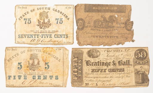
Sold20214 State of South Carolina Obsolete Currency NotesIncludes February 1, 1863 five and seventy-five cent notes, Keatinge & Ball March 15, 1864 50 cent note and 1861 twenty-five cent note. Overall wear, discoloration, tears, and losses. 25 cent note witSee Sold Price
Sold2021COLTONS MAP OF THE WORLD ON MERCATORSPocket map of the world, hand colored, prepared for Henry Bill 1861, having a grape leaf & vine border, 19 1/4 x 27 inches, in display frame, 22 x 28 inchesSee Sold Price
Sold20194 Official Guides 1877, 1888, 18894 Official Guides (national timetable book) February 1877 - 600 pages, June 1888 - 600 pages, February & March 1889 - no covers. Included are railroad and steamship schedules, maps, connections, agentSee Sold Price
Sold2023Auguste Amant Constant Fidèle Edouart(French, 1789-1861) Dr. William Carrol Family, unsigned, dated "8 March 184.." and inscribed across bottom, ink cutout on cream paper with ink wash, sight 9-3/4 x 11 in.; gilt wood frame, 12-3/4 x 14See Sold Price
May 10Hermann Historica GmbH"Operation Chariot" - a military map of the 22nd Naval Flak Regiment, March 27/28, 1942€720
May 09Hunt and Peck Estate Services, Inc.Lot of 3 1st American Edition books by Virginia Woolf$50(1 bid)
May 16Zikorn Arts & History ObjectsU.S. Army Gen. John Buford, the 1st Cavalry Division (1826-1863)$25
May 16Freeman's | HindmanGrandma Moses (American, 1860-1961) The Old Oaken Bucket in Spring, 1944$35,000