Sold2018Mitchell: County Map of Iowa and MissouriMap: County Map of the States of Iowa and Missouri Cartographer: S. A. Mitchell Place/Date: Philadelphia / 1870 Size: 10 3/4" x 13 5/8" Condition: full color; light overall age toning The beautifullySee Sold Price
Sold2022County Map of the States of Iowa and MissouriTitle: County Map of the States of Iowa and Missouri Publication Date: 1867 Title: County Map of the States of Iowa and Missouri Cartographer: W.H. Gamble Publisher: S. Augustus Mitchell, Jr. Height:See Sold Price
Sold20231869 Mitchell Map of US Midwest -- XIV Ohio, Kentucky, Indiana, Illinois, Iowa and Missouri [verso]Title: 1869 Mitchell Map of US Midwest -- XIV Ohio, Kentucky, Indiana, Illinois, Iowa and Missouri [verso] XV Michigan and Wisconsin Cartographer: S Mithchell Year / Place: 1869, Philadelphia Map DimeSee Sold Price
Sold2019Nine (9) Augustus Mitchell MapsCollection of late 19th century United States STATE maps including Minnesota, Iowa and Missouri, State of Maine , Illinois-Missouri-Iowa-Nebraska-and Kansas on one, Two Georgia and Alabama, ConnecticuSee Sold Price
Sold2023Large Map of Illinois Iowa & MissouriMap of Illinois With map of Iowa and Missouri [separately] on versos Cartographer: George Franklin Cram Dated: Circa 1900 Type: Color LithographSee Sold Price
Sold2022(MIDWEST.) George Woolworth Colton. County & Township Railroad Map of the States of Wisconsin,(MIDWEST.) George Woolworth Colton. County & Township Railroad Map of the States of Wisconsin, Illinois, Missouri & Iowa. Large separately issued lithographed map within a decorative foliate border. 3See Sold Price
Sold2017Mitchell: County Map of Texas, 1862County Map of Texas, S. Augustus Mitchell, 1862. 10.75 x 13.375 inches. Steel engraved map, with hand colored wash and outlines. Inset map of Galveston Bay, and Vicinity. Colored by county and territoSee Sold Price
Sold2023Samuel Augustus Mitchell 'County Map of...GA and AL'A Samuel Augustus Mitchell (American, 1792-1868) hand colored engraving titled 'County Map of the States of Georgia and Alabama' depicting the tri-state area of Georgia, Alabama and part of Florida anSee Sold Price
Sold20171862 Mitchell county map of Minnesota in near fineGreat chance to own an actual 150-year-old piece of history for a reasonable price. Beautiful and clean county map of Minnesota from Mitchell’s 1866 New General Atlas. When matted and framed, antiquSee Sold Price
Sold2018Mitchell: County Map of Kentucky & Tennessee, 1870Title/Content of Map: County Map of Kentucky and Tennessee Cartographer: S. A. Mitchell Place & Date: Philadelphia / 1870 Size: 13 3/8" x 9 3/4" Condition: full color; light overall age toning; slightSee Sold Price
Sold2018Mitchell: County Map of Quebec/Montreal InsetCartographer: S. A. Mitchell Place/Date: Philadelphia / 1870 Size: 13 1/4" x 10 3/4" Condition: full color; light overall age toning The beautifully detailed and colored county map of Quebec from theSee Sold Price
Sold2018Mitchell: County Map of Ohio and IndianaMap: County Map of Ohio and Indiana Cartographer: S. A. Mitchell Place/Date: Philadelphia / 1870 Size: 14" x 11 3/4" Condition: full color; light overall age toning The beautifully detailed and coloreSee Sold Price
Sold2018Mitchell: County Map of PennsylvaniaReserve Reduced! The beautifully detailed and colored county map of Pennsylvania from the 1870 edition of Mitchell's popular New General Atlas of the world. The map is framed by the vine motif borderSee Sold Price
Sold2019Mitchell: County Map of Virginia and West VirginiaMap Title: County Map of Virginia and West Virginia Cartographer: S. A. Mitchell Place / Date: Philadelphia / 1870 Size: 14" x 11 5/8" Condition: full color; light overall age toning; tears and frayinSee Sold Price
Sold2016Mitchell: County Map of Florida 1867Map: County Map of Florida Maker: Mitchell Size: 11 x 13.25 inches Counties in original wash color. Inset of Mobile, AL. No Reserve: This lot starts at $1 and has no reserve as a courtesy so that collSee Sold Price
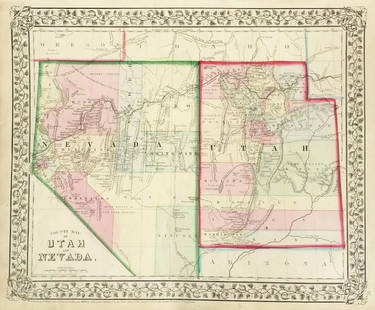
Sold2019Mitchell: County Map of Utah & NevadaMap Title: County Map of Utah and NevadaCartographer: S. A. Mitchell Place/Date: Philadelphia / 1870 Size: 14" x 11 5/8" Condition: full color; light overall age toning The beautifully detailed and coSee Sold Price
Sold2020Mitchell's County Map of the State of New York 1867Mitchell's County Map of the State of New York, 1867, S.Augustus Mitchell. Has some small tearing where the pages are joined but is in otherwise very good condition. Measures approx. 15" tall x 22" wiSee Sold Price
Sold2017Mitchell: Antique Map of Minnesota, 18621862 Mitchell county map of Minnesota in near fine condition. Great chance to own an actual 150-year-old piece of history for a reasonable price. Beautiful and clean county map of Minnesota from MitchSee Sold Price
Sold2017Mitchell: Antique County Map of Texas, 1873Excellent 1873 County Map of Texas by S. Augustus Mitchell. Impressive two-page County Map of the State of Texas. Map image much larger than earlier Mitchell maps. Designed and engraved by W. H. GamblSee Sold Price
Sold2019Samuel Augustus Mitchell (1790-1868), "County Map ofSamuel Augustus Mitchell (1790-1868), "County Map of the States of Georgia and Alabama," 1860, H.- 12 1/4 in., W.- 15 3/8 in.See Sold Price
Sold2017S. Augustus Mitchell: Map of Iowa, 1848Map: Iowa Maker: S. Augustus Mitchell Date: 1848 Size: 13.5 x 16.5 inches One of the earliest obtainable maps of Iowa Condition: Map date half scraped off. Image close to edge as published. Tiny repaiSee Sold Price
Sold2021Civil War era map of Iowa & Missouri, 1861/66Title: Civil War era map of Iowa & Missouri, 1861/66 Description: Vintage map of Iowa and Missouri showing the states at the time of the Civil War. Although the map came from an 1866 edition of MitcheSee Sold Price
Sold2017Mitchell: Antique County Map of Texas, 1870Map: County Map of Texas Cartographer: S. A. Mitchell Place & Date: Philadelphia / 1870 Size: 13 1/4" x 10 3/4" Condition: full color; light overall age toning The beautifully detailed and colored couSee Sold Price
Sold2018Mitchell: Antique County Map of Florida, 1870County Map of Florida The beautifully detailed and colored county map of Florida from the 1870 edition of Mitchell's popular New General Atlas of the world. Framed by the vine motif border typical ofSee Sold Price
May 19Heartland Artifact Auctions Inc5.1/8" Granite 3/4 Groove Axe, Ex Jim Millard, County Iowa$55(2 bids)
May 19Heartland Artifact Auctions Inc2 1/8" Agate Basin, Red Jasper, Keele COA, . Found in Sullivan County Missouri, Ex Steve McCabe$110(6 bids)
May 19Heartland Artifact Auctions Inc1.3/4" Miniature Discoidal, Nicely cupped and formed. Found in Pike County Missouri. White Quartz.$10(1 bid)
May 19Heartland Artifact Auctions Inc2" Incised / Engraved Game Ball. Found in Sullivan County Missouri, Ex Steve McCabe Coll.$10
May 19Heartland Artifact Auctions IncLot of 4 Arrowheads found by Terry Annin in Jefferson County Missouri$10
3 days LeftJasper521896 Cram Map of Virginia, West Virginia, Maryland and Delaware -- Railroad and County Map of$40
May 19Heartland Artifact Auctions Inc1.7/8" Graham Cave, Pike County Missouri, found by Jody Wells$10
May 19Heartland Artifact Auctions Inc4" Missouri 3/4 Groove Axe, Nice Complete Example, Fluted, Ex Steve McCabe Collection, Sullivan$10(1 bid)
May 19Heartland Artifact Auctions Inc4" Archaic Knife, Realy Unique with Hole through it from material deteriorating. Shelby County$10


![1869 Mitchell Map of US Midwest -- XIV Ohio, Kentucky, Indiana, Illinois, Iowa and Missouri [verso]: Title: 1869 Mitchell Map of US Midwest -- XIV Ohio, Kentucky, Indiana, Illinois, Iowa and Missouri [verso] XV Michigan and Wisconsin Cartographer: S Mithchell Year / Place: 1869, Philadelphia Map Dime](https://p1.liveauctioneers.com/5584/305309/163064973_1_x.jpg?height=310&quality=70&version=1697577828)

![Large Map of Illinois Iowa & Missouri: Map of Illinois With map of Iowa and Missouri [separately] on versos Cartographer: George Franklin Cram Dated: Circa 1900 Type: Color Lithograph](https://p1.liveauctioneers.com/5614/294993/156626705_1_x.jpg?height=310&quality=70&version=1688581746)