Sold2022MOLL (HERMAN) Atlas Manuale: or, a New Sett of Maps of All the Parts of the Earth, 1723; and Owe...MOLL (HERMAN) Atlas Manuale: or, a New Sett of Maps of All the Parts of the Earth, as well as Asia, Africa, and America, as Europe... and the Coasts of all Countries are laid down, agreeable to Mr. EdSee Sold Price
Sold2022MOLL, HERMAN. A New Map of the North Parts of America claimed by France under ye Names of Louisiana,MOLL, HERMAN. A New Map of the North Parts of America claimed by France under ye Names of Louisiana, Mississipi, Canada and New France with ye Adjoyning Territories of England and Spain. Large engraveSee Sold Price
Sold2022Italy.- Moll (Herman) A New Map of the Upper Part of Italy, engraved map with hand-colouring, [c.Italy.- Moll (Herman) A New Map of the Upper Part of Italy, containing ye Principality of Piedmont by ye Dutchies of Savoy, Milan, Parma, Mantua, Modena, Tuscany, the Dominions of ye Pope, &c. The RepSee Sold Price
Sold2024Herman Moll A New Map of Ye North Parts of AmericaHerman Moll (British, 1654-1732). Colored engraved map, A New Map of Ye North Parts of America Claimed by France Under Ye Names of Louisiana, Mississipi [sic], Canada & New France, With the AdjoiningSee Sold Price
Sold2022Scandinavia.- Moll (Herman) A New Map of Denmark and Sweden according to ye newest and most exactScandinavia.- Moll (Herman) A New Map of Denmark and Sweden according to ye newest and most exact observations..., large detailed map with inset map of the Northern part of Norway, Lapland and GreenlaSee Sold Price
Sold2024Map of the North Parts of America Claimed by France by Herman Moll (London, 1720)Map of the North Parts of America Claimed by France by Herman Moll (London, 1720) "A New Map of the North Parts of America claimed by France under ye Names of Louisiana, Mississippi, Canada, and New FSee Sold Price
Sold2016Map of Newfoundland by Herman Moll 1729Map: New Found Land, St Laurens Bay, The Fishing Banks, Acadia, and Part of New Scotland Maker: Herman Moll Date: 1729 (1730-32) Size: 8 x 10.25 inches Newfoundland and Nova Scotia in original outlineSee Sold Price
Sold2017Moll - Correct Map of the Whole World, 1719Herman Moll (1654?-1732), cartographer and publisher A New & Correct Map of the Whole World Shewing y.e Situation of its Principal Parts. Viz the Oceans, Kingdoms, Rivers, Capes, Ports, Mountains, WooSee Sold Price
Sold2019Moll Map of Peru and AmazonMOLL, Herman (1654-1732). A Map of Peru and the West Part of the Country of the Amazones. Engraved map from Atlas Geographus. London, c. 1711-1717. 13 1/4" x 8 1/2" sheet.See Sold Price
Sold2022MAP, Middle East, MollMiddle East & Cyprus. Herman Moll, The North Part of Turky in Asia Containing Asia Minor, Armenia, Syria, Diarbeck, Irac-Arabick &c., from Atlas Geographus, 1712 (circa). Black & White. This uncommonSee Sold Price
Sold2019Herman Moll 1654-1732), "A New And Correct Map of theHerman Moll 1654-1732), "A New And Correct Map of the World," 1710, hand colored, H. - 22 in., W. - 38 in.See Sold Price
Sold2017FRAMED WORLD MAP BY HERMAN MOLL, 1719'A New & Correct Map of the Whole World, by Herman Moll, Geographer, 1719.' Hand tinted and framed. Frame size: 73 x 124 cm (28 3/4 x 48 3/4 in.)See Sold Price
Sold2022BEAVER MAP, HERMAN MOLL (DUTCH/BRITISH, 1654-1732)A New and Exact Map of the Dominions of the King of Great Britain on ye Continent of North America containing Newfoundland, New Scotland, New England, New York, New Jersey, Pensilvania, Maryland, VirgSee Sold Price
Sold2023[MAP]. FRY & JEFFERSON. A Map of the Most Inhabited Part of Virginia. 1775. FIRST PRINTED MAP OF[MAPS & ATLASES]. FRY, Joshua (1699-1754) and Peter JEFFERSON (1708-1757). A Map of the Most Inhabited Part of Virginia containing the whole Province of Maryland with Part of Pensilvania, New JersSee Sold Price
Sold20221833 Jos. Perkins A New General Atlas Map Book1833, written and engraved by Jos. Perkins, publisher - Anthony FinleySee Sold Price
Sold2022MITCHELL, SAMUEL AUGUSTUS. A New Universal Atlas Containing Maps of the Various Empires, Kingdoms,MITCHELL, SAMUEL AUGUSTUS. A New Universal Atlas Containing Maps of the Various Empires, Kingdoms, States and Republics of the World; With a Special Map of Each of the United States, Plans of Cities,See Sold Price
Sold2022MITCHELL'S UNIVERSAL ATLASNew Universal Atlas Containing Maps of the various Empires, Kingdoms, States, and Republics of the World, S. Augustus Mitchell, Philadelphia, 1847; Condition: boards detached; 17 1/4 x 14 inchesSee Sold Price
Sold2017Mitchell's 1849 New Universal AtlasHeading: Author: Mitchell, S. Augustus Title: New Universal Atlas Containing Maps of the various Empires, Kingdoms, States and Republics of the World. With a special map of each of the United States,See Sold Price
Sold2016Mitchell's New Universal Atlas 1847Heading: Author: Mitchell, S. Augustus Title: A New Universal Atlas Containing Maps of the Various Empires, Kingdoms, States and Republics of the World with a Special Map of each of the United StatesSee Sold Price
Sold2018[ATLASES].* [ATLASES]. Four editions of Mitchell's New General Atlas, Containing Maps of the Various Countries of the World, Plans of Cities, Etc. Philadelphia: S. Augustus Mitchell, Jr., 1861 - 1864 - 1878 - 1See Sold Price
Sold2017World.- SDUK Atlas.- Maps of the Society for theWorld.- SDUK Atlas.- Maps of the Society for the Diffusion of Useful Knowledge, 4 parts in 1, parts 1-2 with 207 engraved maps, hand-coloured in outline, a few double-page, part 3 "Stars" with 6 hand-See Sold Price
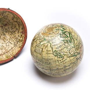
Sold2023(GLOBES.) Style of Herman Moll. A Correct Globe with the New Discoveries.(GLOBES.) Style of Herman Moll. A Correct Globe with the New Discoveries. 2¾-inch miniature terrestrial pocket globe comprised of 12 hand-colored engraved gores and 2 polar calottes on a plasterSee Sold Price
Sold2022RARE 18TH CENTURY CHINESE ATLASA rare 18th century Chinese Atlas titled ' Nouvel Atlas de la Chine, de la Tartarie Chinoise et du Thibet' (translated: New Maps of China, Inner Mongolia & Tibet) is considered to be the most compreheSee Sold Price
Sold2022MOLL, HERMAN. [The World Described].MOLL, HERMAN. [The World Described]. 18 engraved multiple-sheet folding maps with original outline hand-color (i.e., incomplete; no beaver map, no codfish map). Tall folio, 25x12 inches, period calf bSee Sold Price
4 days LeftTrillium Antique Prints & Rare BooksMitchell's A New Universal Atlas.. - Volume with 73 Maps$1,000(1 bid)
18 hrs LeftJasper521867 Beers Map of New York City Area -- Map of New York and Vicinity Accompanying "Atlas of New York$200
18 hrs LeftJasper521723 Dampier Map of Voyages to Brazil, Australia and Eat Indies -- Voyage du Cap. Dampier a la N.$280
May 14Akiba Galleries(2 Pc) Allain Manesson Mallet Description De L'Univers 2 Vol. German Translation$200(1 bid)
May 09Hunt and Peck Estate Services, Inc.Abraham Ortelius map of Bitiurigum from Theatrum Orbis Terrarum$50
1 day LeftDoyle New YorkMarshall's Life of George Washington with an important annotation by James McHenry$1,300(1 bid)


![Herman Moll A New Map of Ye North Parts of America: Herman Moll (British, 1654-1732). Colored engraved map, A New Map of Ye North Parts of America Claimed by France Under Ye Names of Louisiana, Mississipi [sic], Canada & New France, With the Adjoining](https://p1.liveauctioneers.com/7691/320359/172153415_1_x.jpg?height=310&quality=70&version=1708543789)


![[MAP]. FRY & JEFFERSON. A Map of the Most Inhabited Part of Virginia. 1775. FIRST PRINTED MAP OF: [MAPS & ATLASES]. FRY, Joshua (1699-1754) and Peter JEFFERSON (1708-1757). A Map of the Most Inhabited Part of Virginia containing the whole Province of Maryland with Part of Pensilvania, New Jers](https://p1.liveauctioneers.com/197/305583/163286504_1_x.jpg?height=310&quality=70&version=1697143109)


![[ATLASES].: * [ATLASES]. Four editions of Mitchell's New General Atlas, Containing Maps of the Various Countries of the World, Plans of Cities, Etc. Philadelphia: S. Augustus Mitchell, Jr., 1861 - 1864 - 1878 - 1](https://p1.liveauctioneers.com/197/119933/61100820_1_x.jpg?height=310&quality=70&version=1522758048)


![MOLL, HERMAN. [The World Described].: MOLL, HERMAN. [The World Described]. 18 engraved multiple-sheet folding maps with original outline hand-color (i.e., incomplete; no beaver map, no codfish map). Tall folio, 25x12 inches, period calf b](https://p1.liveauctioneers.com/199/251723/130782476_1_x.jpg?height=310&quality=70&version=1655133895)


![[MAP - TOURS] (1 of 1)](https://p1.liveauctioneers.com/292/326828/175962850_1_x.jpg?height=282&quality=70&version=1713473479)


