Sold2022Netherlands, Belgium and Luxembourg. 1862 by Johnson and WardTitle: Netherlands, Belgium and Luxembourg. 1862 by Johnson and Ward Date/Period: 1862 Materials: Steel plate engraved. Size: 19" x 14" With inserts of Amsterdam and Brussels. 1862 from 'Johnson's NewSee Sold Price
Sold2022Netherlands, Belgium, Luxembourg. 1780, by J. de laTitle: Netherlands, Belgium, Luxembourg. 1780, by J. de la Porte, Paris Date/Period: 1780 Materials: Hand colored copper plate engraved Size: 9x7'' Condition, center fold separation on bottom otherwisSee Sold Price
Sold2022Netherlands, Belgium, Luxembourg and Westphalia region of Germany. 1794 by Vaugondy/DelamarcheTitle: Netherlands, Belgium, Luxembourg and Westphalia region of Germany. 1794 by Vaugondy/Delamarche Date/Period: 1794 Dimension: 16 x 11 1/2" Material: Hand colored copper plate engraved. AdditionalSee Sold Price
Sold2021Central and Eastern Europe by Bonne/ Raynal 1780Title: Central and Eastern Europe by Bonne/ Raynal 1780 Date/Period: 1780 Materials: Copperplate engraved Size: 13 1/2 x 9'' Map centers on Germany, but Netherlands, Belgium, Luxembourg, Austria, SwitSee Sold Price
Sold2018Colton: Antique Map of Netherlands, Belgium, 1859Netherlands, Belgium & Luxembourg with insterst of Brussels & Amsterdam 1859 H.J. Colton 17 1/2" x 15" Hand colored and engraved. Published in New York in Colton's 'General Atlas'. Please note that thSee Sold Price
Sold2023Gross, Alexander 1920 Lot of 26 Large Maps. EuropeIncl Germany, Austria, Russia, Netherlands, Belgium/Luxembourg, Norway/Sweden, Denmark/Iceland, Switzerland, Italy, France/Switzerland, Spain/Portugal, Europe Continent. Large Lithograph Maps PublisheSee Sold Price
Sold2019Scarce 1862 Neb/Dak/Col/Kans - Johnson & WardReserve Reduced! One of the rarest and most desirable states of Johnson's Dakota, Nebraska and Kansas map. In this example Nebraska is drawn with a long panhandle extending from Iowa all the way to FrSee Sold Price
Sold2022Dakota’s and Minnesota. 1862, Johnson and WardTitle: Dakota’s and Minnesota. 1862, Johnson and Ward Date/Period: 1862 Materials: Steel plate engraved Size: 19" x 14" 1862 from 'Johnson's New Illustrated Family Atlas' By Johnson and Ward. PuSee Sold Price
Sold2022Title page. 1862. Johnson and WardTitle: Title page. 1862. Johnson and Ward Date/Period: 1862 Materials: Steel plate engraved. Size: 19" x 14" 1862 from 'Johnson's New Illustrated Family Atlas'. By Johnson and Ward. Published in New YSee Sold Price
Sold2020Hand colored copper engraved map by Homann, 1715Johann Baptist Homann (German, 1664-1724), hand colored copper engraved map, 1715, 'Provinciae XVII Infer. Germaniae,' depicting the Netherlands, Belgium, and Luxembourg in addition to parts of FranceSee Sold Price
Sold20241862 Civil War-era map of Alabama/Georgia, Johnson & WardJohnson’s Georgia and Alabama from the 1862 edition of Johnson’s Family Atlas published during the second year of the war in 1862 by Johnson & Ward. Shows railroads operating at the beginnSee Sold Price
Sold20201831 Teesdale Map of Netherlands, Belgium andTitle/Content of Map: 1831 Teesdale Map of Netherlands, Belgium and Luxembourg -- Netherlands Date: 1831, London Cartographer: H Teesdale Size: 16.1 X 13.2 in. This is a very nice and detailed map ofSee Sold Price
Sold20201855 Colton Map of the Netherlands, Belgium andTitle: 1855 Colton Map of the Netherlands, Belgium and Luxembourg -- Holland and Belgium Cartographer: J Colton Year/Place: 1855, New York Dimensions: 14.7 X 12.8 in. Descriptions: This is a very niceSee Sold Price
Sold2019Johnson’s North America, Johnson & Ward, 1862Interesting configuration of North America, particularly the United States, Canada and Mexico, just after the outbreak of the Civil War. States roughly follow the 1861 configuration with archaic bordeSee Sold Price
Sold2022North America, 1862 by Johnson and WardTitle: North America, 1862 by Johnson and Ward Date/Period: 1862 Materials: Steel plate engraved Size: 19" x 27" 1862 from 'Johnson's New Illustrated Family Atlas' By Johnson and Ward. Published in NeSee Sold Price
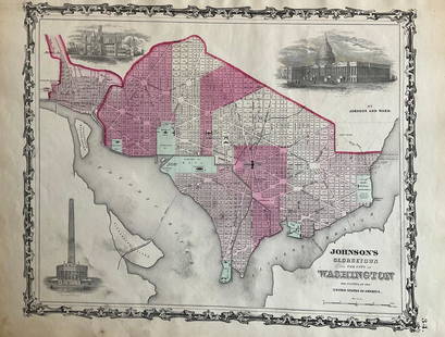
Sold2022Washington D.C. 1862 by Johnson and WardTitle: Washington D.C. 1862 by Johnson and Ward Date/Period: 1862 Materials: Steel plate engraved Size: 19" x 14" 1862 from 'Johnson's New Illustrated Family Atlas' By Johnson and Ward. Published in NSee Sold Price
Sold2022New York. 1862. By Johnson and WardTitle: New York. 1862. By Johnson and Ward Date/Period: 1862 Materials: Steel plate engraved Size: 19" x 27" With inserts of eight cities including New York City, Buffalo, and Albany among others. 186See Sold Price
Sold2022Mexico, 1862 by Johnson and WardTitle: Mexico, 1862 by Johnson and Ward Date/Period: 1862 Materials: Steel plate engraved Size: 19" x 14" 1862 from 'Johnson's New Illustrated Family Atlas' By Johnson and Ward. Published in New York.See Sold Price
Sold2021Belgium, Netherlands & Luxembourg, RARE Swedish issueTitle: Belgium, Netherlands & Luxembourg, RARE Swedish issue by A. Akerman 1768-1774 Date/Period: 1768-1774 Materials: Copperplate engraved Size: 7 1/2 x 6”. Scarce map shows the provinces of thSee Sold Price
Sold2022Maryland and Delaware 1862 by Johnson and WardTitle: Maryland and Delaware 1862 by Johnson and Ward Date/Period: 1862 Materials: Steel plate engraved Size: 19" x 14" 1862 from 'Johnson's New Illustrated Family Atlas' By Johnson and Ward. PublisheSee Sold Price
Sold2022North & South Carolina, insert of Charleston , 1862 by Johnson and WardTitle: North & South Carolina, insert of Charleston , 1862 by Johnson and Ward Date/Period: 1862 Materials: Steel plate engraved Size: 19" x 27" 1862 from 'Johnson's New Illustrated Family Atlas' By JSee Sold Price
Sold2022Cuba, Jamaica with inserts of Puerto Rico and Havana, 1862 by Johnson and WardTitle: Cuba, Jamaica with inserts of Puerto Rico and Havana, 1862 by Johnson and Ward Date/Period: 1862 Materials: Steel plate engraved Size: 19" x 14" 1862 from 'Johnson's New Illustrated Family AtlaSee Sold Price
Sold2022Austrian empire, Hungary, entire Balkans, 1862 by Johnson and WardTitle: Austrian empire, Hungary, entire Balkans, 1862 by Johnson and Ward Date/Period: 1862 Materials: Steel plate engraved. Size: 19" x 27" 1862 from 'Johnson's New Illustrated Family Atlas'. By JohnSee Sold Price
Sold2022Ireland, 1862 by Johnson and WardTitle: Ireland, 1862 by Johnson and Ward Date/Period: 1862 Materials: Steel plate engraved. Size: 19" x 14" 1862 from 'Johnson's New Illustrated Family Atlas'. By Johnson and Ward. Published in New YoSee Sold Price
6 days LeftJasper521792 Elwe Map of Southern Netherlands to Belgium to Northern France -- Carte Nouvelle des Pais Bas$80
6 days LeftJasper521792 Elwe Map of the Netherlands and Belgium -- Les Dix-Sept Provinces des Pays-Bas$80
6 days LeftJasper521579 Ortelius Map of Parts of Belgium and Holland -- Brabantiae, Germaniae Inferioris Nobilissimae$160
3 days LeftSeized Assets AuctioneersSir Peter Paul Rubens - Achilles Educated by the Centaur Chiron$1