Sold2022North America, 1862 by Johnson and WardTitle: North America, 1862 by Johnson and Ward Date/Period: 1862 Materials: Steel plate engraved Size: 19" x 27" 1862 from 'Johnson's New Illustrated Family Atlas' By Johnson and Ward. Published in NeSee Sold Price
Sold2019Johnson’s North America, Johnson & Ward, 1862Interesting configuration of North America, particularly the United States, Canada and Mexico, just after the outbreak of the Civil War. States roughly follow the 1861 configuration with archaic bordeSee Sold Price
Sold2019Johnson & Ward, "North America," 1862, hand colored,Johnson & Ward, "North America," 1862, hand colored, H.- 26 1/2 in., W.- 18 in.See Sold Price
Sold2019Three Maps: consisting of Johnson & Ward, "UnitedThree Maps: consisting of Johnson & Ward, "United States," 1864, hand colored, H.- 17 7/8 in., W.- 26 1/2 in.; together with two copies of Johnson & Ward, "North America," 1861-1863, H.- 26 1/2 in., WSee Sold Price
Sold2020Early Civil War era map of AmericaNice example of A. J. Johnson's 1862 map of North America. Presents a fascinating snapshot of North America just after the outbreak of the American Civil War. States generally follow the 1861 configurSee Sold Price
Sold2021North America, Johnson 1863Dramatic and large double-page format with great full, original hand coloring. Johnson’s North American, published 1863 by Johnson and Ward. Repaired extreme corner tips. One small repaired edge teaSee Sold Price
Sold2022North & South Carolina, insert of Charleston , 1862 by Johnson and WardTitle: North & South Carolina, insert of Charleston , 1862 by Johnson and Ward Date/Period: 1862 Materials: Steel plate engraved Size: 19" x 27" 1862 from 'Johnson's New Illustrated Family Atlas' By JSee Sold Price
Sold2023Johnson's Family Atlas of the World 1865Johnson's New Illustrated (Steel Plate) Family Atlas published in 1865 by Johnson and Ward hand colored maps of the United States and the world ( DOUBLE PAGE, AND FULL PAGE MAPS OF NORTH AMERICA, SOUTSee Sold Price
Sold2019Four Maps by Johnson & Ward, consisting of: "North andFour Maps by Johnson & Ward, consisting of: "North and South Carolina," 1862, hand colored, H.- 18 in., W.- 26 3/4 in.; "Arkansas, Mississippi, Louisiana," 1863, hand colored, H.- 26 1/2 in., W.- 18 iSee Sold Price
Sold2022Important 1862 map of N. America/United StatesOne of Johnson's first and most desirable issues of this great map of North America. Features an extremely interesting transitional period of the United States shortly after the outbreak of the CivilSee Sold Price
Sold2017A MANUAL OF THE MEDICAL BOTANY OF NORTH AMERICA .A MANUAL OF THE MEDICAL BOTANY OF NORTH AMERICA . JOHNSON, Laurence.; New York: William Wood & Co., 1884; HC. 1st Ed. 292pp. 8vo, Yellow mustard cloth boards w/black stencil dec., "WOOD'S LIBRARY OF SSee Sold Price
Sold2019Scarce 1862 Neb/Dak/Col/Kans - Johnson & WardReserve Reduced! One of the rarest and most desirable states of Johnson's Dakota, Nebraska and Kansas map. In this example Nebraska is drawn with a long panhandle extending from Iowa all the way to FrSee Sold Price
Sold2022Dakota’s and Minnesota. 1862, Johnson and WardTitle: Dakota’s and Minnesota. 1862, Johnson and Ward Date/Period: 1862 Materials: Steel plate engraved Size: 19" x 14" 1862 from 'Johnson's New Illustrated Family Atlas' By Johnson and Ward. PuSee Sold Price
Sold20211861 North America. By JohnsonTitle: 1861 North America. By Johnson Date/Period: 1861 Materials: Steel engraved. Size: 26 1/2 x 17 3/4” 1861. By A. J. Johnson & J. H Colton. From "Johnson's New Illustrated Family Atlas' publisheSee Sold Price
Sold2022Title page. 1862. Johnson and WardTitle: Title page. 1862. Johnson and Ward Date/Period: 1862 Materials: Steel plate engraved. Size: 19" x 14" 1862 from 'Johnson's New Illustrated Family Atlas'. By Johnson and Ward. Published in New YSee Sold Price
Sold20241862 Civil War-era map of Alabama/Georgia, Johnson & WardJohnson’s Georgia and Alabama from the 1862 edition of Johnson’s Family Atlas published during the second year of the war in 1862 by Johnson & Ward. Shows railroads operating at the beginnSee Sold Price
Sold2022Johnson's North America by Alvin Jewett Johnson &Title/Content of Map: Johnson's North America by Alvin Jewett Johnson & Benjamin P Ward Date Printed: 1864 Cartographer: Alvin Jewett Johnson & Benjamin P Ward Material/Medium: Engraving Size: 17.5 xSee Sold Price
Sold20231866 Johnson's North AmericaTitle: 1866 Johnson's North America Cartographer: Johnson and Ward Year / Place: 1866, New York Map Dimension (in.): 22 X 17.1 in. This is an excellent double-page map of North America. The just postSee Sold Price
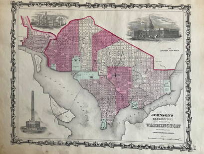
Sold2022Washington D.C. 1862 by Johnson and WardTitle: Washington D.C. 1862 by Johnson and Ward Date/Period: 1862 Materials: Steel plate engraved Size: 19" x 14" 1862 from 'Johnson's New Illustrated Family Atlas' By Johnson and Ward. Published in NSee Sold Price
Sold2021Johnson's North AmericaPublication Date: 1864 Title: Johnson's North America Cartographer: JOHNSON AND WARD Publisher: JOHNSON AND WARD Height: 21 Width: 17 Such details in U.S. as tip of NV in AZ, large DK & ID, U.S. MailSee Sold Price
Sold2019Johnson's North AmericaReserve Reduced! Title: Johnson's North America Publication Date: 1862 Cartographer: JOHNSON, ALVIN JEWETT Publisher: JOHNSON AND WARD Size: 21 x 16 The entire continent from a Civil War era atlas. ShSee Sold Price
Sold2018Johnson's North AmericaTitle/Content of Map: Johnson's North America Date: 1862 Cartographer: JOHNSON AND WARD Size: 21X15.3 Map showing lg. NM, DK & WA territories, AK is Russian Possession, U.S. Mail route, Indian tribes,See Sold Price
Sold2022New York. 1862. By Johnson and WardTitle: New York. 1862. By Johnson and Ward Date/Period: 1862 Materials: Steel plate engraved Size: 19" x 27" With inserts of eight cities including New York City, Buffalo, and Albany among others. 186See Sold Price
Sold2022Mexico, 1862 by Johnson and WardTitle: Mexico, 1862 by Johnson and Ward Date/Period: 1862 Materials: Steel plate engraved Size: 19" x 14" 1862 from 'Johnson's New Illustrated Family Atlas' By Johnson and Ward. Published in New York.See Sold Price
6 days LeftJasper521761 NEW DICTIONARY OF TRADE & COMMERCE R. ROLT antique FOLIO ILLUSTRATED w/MAPS$440
May 16Potter & Potter AuctionsSTORM, Mark. Official Texas Brags Map of North America. 194...$200(1 bid)


![[1915] Quaint and Historic Forts of North America (1 of 5)](https://p1.liveauctioneers.com/5755/327684/176532954_1_x.jpg?height=282&quality=70&version=1714078974)


