Sold2022New Holland & Asiatic islands Australia New Zealand Polynesia THOMSON 1817 mapTITLE/CONTENT OF MAP: 'New Holland and Asiatic islands' DATE PRINTED: Published in 1817. Engraved in 1814; this date is marked on the map IMAGE SIZE: Approx 52.0 x 64.0cm, 20.5 x 25.25 inches (Large);See Sold Price
Sold2020"New Holland & Asiatic islands" Australia New ZealandTITLE/CONTENT OF MAP: 'New Holland and Asiatic islands' The top image on the right hand side shows the entire map. To view a close up of the map showing the level of printed detail, please click on thSee Sold Price
Sold2017New Holland & Asiatic Islands Map, Thomson, 1817TITLE/CONTENT OF MAP: 'New Holland and Asiatic islands' DATE PRINTED: 1817 IMAGE SIZE: Approx 53.0 x 65.0cm, 21 x 25.5 inches (Large); Please note that this is a folding map. TYPE: Antique early 19thSee Sold Price
Sold2017Thomson: Antique Map of New Holland (Australia), 1814Map: New Holland and Asiatic Islands Cartographer: Thomson Place & Date: Edinburgh / 1814/1817 Size: 24 1/4" x 19 3/4" Condition: overprinting and some staining; repaired splits along centerfold and nSee Sold Price
Sold2023PACIFIC OCEAN. Australia New Zealand Polynesia Micronesia. BLACKIE 1893 mapTITLE/CONTENT OF MAP: 'The Pacific Ocean, general map' DATE PRINTED: 1893 IMAGE SIZE: Approx 35.0 x 51.5cm, 13.75 x 20.25 inches (Large); Please note that this is a folding map. TYPE: Colour Antique mSee Sold Price
Sold2017Weller: Map of Pacific, Hawaii Australia New ZealandTITLE/CONTENT OF MAP: 'The Pacific Ocean'. Sandwich Islands/Hawaii Australia New Zealand This map is folding hence the centrefold line may show on the image below DATE PRINTED: 1862 IMAGE SIZE: ApproxSee Sold Price
Sold2018Pacific OceanTitle/Content of Map: Pacific Ocean Date Printed: 1840-05-15 Cartographer: WALKER, J. & C. Size: 12.2X15.5 Details from the Aleutian Island to Australia/New Zealand and to Cape Horn/South America. DetSee Sold Price
Sold2016Hawaiian & Pacific Polynesian Islands, Australia, 1850Original engraving by Samuel Augustus Mitchell from Mitchell’s Universal Atlas, 1850. Map highlights the Pacific ocean & surrounding islands; Hawaii, Polynesian, Australia & New Zealand. Dimensions:See Sold Price
Sold2021Australien und Polynesien (Australia & Polynesia)Title: Australien und Polynesien (Australia & Polynesia) Publisher: Haack Height: 62 Width: 82 Handsome and enormous display map of the South Pacific from All of Australia, New Zealand through most ofSee Sold Price
Sold2022Australia & Oceania Used Stamp CollectionA large collection of used stamps including singles and doubles from various Oceania countries - Australia, British Solomon Islands, Fiji, French Polynesia, New Caledonia, New Zealand, Papua New GuineSee Sold Price
Sold2017Thomson: Map of the Islands of the Pacific Ocean, 1817Map: Map of the Islands of the Pacific Ocean Cartographer: Thomson Place & Date: Edinburgh / 1817 Size: 23 3/4" x 19 1/2" The grand Pacific Islands map from Thomson's New General Atlas, showing all thSee Sold Price
Sold2018Weller, F. S. C1890 Lot of 12 Antique MapsIncl German Empire, Switzerland, Holland/Belgium, Austria/Hungria, Russia, Asia, Africa, Sweden/Norway & Denmark, France, Australasia, Eastern Australia and New Zealand, and The World. Lot of 12 LithoSee Sold Price
Sold2017Thomson: Antique Map of West India Islands, 1817A map of the West India Islands including St. Christophers, Nevis and St. Lucia by Scottish cartographer John Thomson for his 1817 "New General Atlas." The map is printed on thick paper and was engravSee Sold Price
Sold2017Neele: Antique Map Islands of the Pacific Ocean, 1817Map: Map of the Islands in the Pacific Ocean Publication Date: 1817 Cartographer: NEELE, sc. Publisher: THOMSON'S NEW GENERAL ATLAS Size: Folio – 19.50 H x 23.75 W Inches From a famous Scottish atlaSee Sold Price
Sold2024New Zealand Sandwich Galapagos Islands. Papuan Archipelago. Melanesia 1860 mapCAPTION PRINTED BELOW PICTURE: 'New Zealand. // Sandwich Islands, or Hawaiian Group, // Galapagos Islands // Papuan Archipelago' The islands of New Zealand are named with their early colonial and MaorSee Sold Price
Sold2019Nicolao Visscher. Orbis Terrum Nova MapNicolao Visscher (Dutch, 1618-1709). A hand-colored engraved map, circa 1658. Orbis Terrum Nova et Accuratussna Tabula. Showing partial coastlines of New Zealand and Australia. Unframed. 23-1/2 in x 2See Sold Price
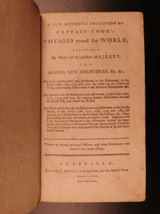
Sold20191786 VERY RARE Voyages of Captain James Cook Hawaii1786 VERY RARE Voyages of Captain James Cook Hawaii Pacific Australia New Zealand “Remember, the greater the opportunity, the fewer are those who see it.” – James Cook James Cook was an 18th-cenSee Sold Price
Sold2024Large Lot of Sterling Silver Souvenir SpoonsLarge Lot of Mostly Sterling Silver Souvenir Spoons, 66 total spoons, including examples from Africa, the Middle East, Greece, Turkey, Philipines, Russia, Australia, New Zealand, Hong Kong, Vietnam, SSee Sold Price
Sold2023Forty One World TokensForty one world Tokens from Canada, New Zealand, Australia etc. Descriptions, weights, sizes and conditions are our best judgement and do not represent a guarantee. All jewelry, coins and numismatic mSee Sold Price
Sold2016Town of Southampton Map (North Haven & Art Village),Original engraving of Southhampton town, including Peconic Bay, Hobson Island and many landmarks & family names. Published by E. Belcher Hyde from "Atlas of Suffolk County, Long Island, New York," 190See Sold Price
Sold2017Rare - 1768 Holland - Jeffreys Map of New York and NewThe rarest and earliest state of a seminal map. The Provinces of NEW YORK and NEW JERSEY with part of PENSILVANIA, and the Governments of TROIS RIVIERES, and MONTREAL: drawn by Capt. Holland. / A ChorSee Sold Price
Sold201820th C. Maori Oyster Shell Pectoral, ex-Duke KahanamokuOceania/Polynesia, New Zealand, Maori people, ca. mid 20th century CE. A huge oyster shell pectoral, presented to Duke Kahanamoku (1890-1968) on his trip to New Zealand. The shell has a rich, butterySee Sold Price
Sold2022MACLEOD, Alexander Samuel (1888-1956). A Map of Honolulu an...MACLEOD, Alexander Samuel (1888-1956). A Map of Honolulu and the Sandwich Islands which we now call the Hawaiian Islands. 1927. New York: Henry M. Snyder. Scarce and detailed map of Honolulu, with anSee Sold Price
Sold2022Jacob Monk Wall Map of North America 1860Monk's Standard American Map exhibiting the larger portion of North America Embracing The United States and Territories, Mexico, Central America, including the West India Islands, Canada, New BrunswicSee Sold Price
May 14Akiba Galleries(2 Pc) Allain Manesson Mallet Description De L'Univers 2 Vol. German Translation$200(1 bid)
May 11Crescent City Auction GalleryWilliam H. Williams (1817-1886), New Orleans "Map of the Sixth District and Carrollton," 1871, H.-$650
3 days LeftTremont AuctionsJohn Speed and Francis Lamb "Map of New England and New York", ca. 1676. Hand colored engraved map$900(3 bids)
12 hrs LeftDixon's Crumpton AuctionPre-Central Park Map of New York City, David H. Burr / Simeon DeWitt 1829$225(4 bids)
Jun 16Broward Auction GalleryATTRIB George Forster (NY,German,1817-1896) oil painting antique$20(2 bids)