Sold2022Nice example of ext. scarce map of North Carolina (1814)Extremely scarce map of Samuel Lewis map of North Carolina, appearing in the extremely scarce 1816 edition of Carey’s General Atlas (same map as in the 1814 Carey atlas). Early nineteenth centurSee Sold Price
Sold2022Scarce 1705 map of North America by Nicolas de Fer (Calif. as island)Nice example of de Fer's scarce map of North America, first published in Paris in 1693. This specimen with a 1705 date is from the 1723 edition of de Fer’s Petit et Nouveau Atlas and features laterSee Sold Price
Sold2022Scarce 1st ed. Colton RR map of North CarolinaLovely example of North Carolina map from the first edition of Colton’s Atlas of the World. One of the few mid-19th century maps to show North Carolina independently—it was more often mappSee Sold Price
Sold2022Pre-Civil War school atlas map of East Coast states, 1849Very nice map of East Coast states showing Virginia fourteen years before West Virginia becomes a state. Nice example with full original hand coloring. No. 4 Virginia, North Carolina, South Carolina,See Sold Price
Sold20211855 Colton Map of North Carolina -- North CarolinaTitle: 1855 Colton Map of North Carolina -- North Carolina Cartographer: J Colton Year / Place: 1855, New York Map Dimension (in.): 11.8 X 15.5 in. This is a very nice map of North Carolina with insetSee Sold Price
Sold20221855 Colton Map of North Carolina -- North CarolinaTitle: 1855 Colton Map of North Carolina -- North Carolina Cartographer: J Colton Year / Place: 1855, New York Map Dimension (in.): 11.8 X 15.5 in. This is a very nice map of North Carolina with insetSee Sold Price
Sold2023Extremely scarce map of South Carolina (1814)Scarce third state of Samuel Lewis’s map of South Carolina, appearing in the extremely scarce 1816 edition of Carey’s General Atlas (same map as in the 1814 Carey atlas). One of the earlieSee Sold Price
Sold2022Scarce early Cram RR map of North CarolinaDesirable and scarce railroad map of North Carolina from a very scarce and early Cram atlas. The 1882 edition of Cram’s Unrivaled Family Atlas of the World was the last Cram atlas to use hand cSee Sold Price
Sold2023W.A. Flowers Folk Art North Carolina Pottery Face JugNice example. Signed W. A. Flowers, North Carolina Southern folk art face jug in the form of a grotesque man circa 2010.See Sold Price
Sold2022SHELL GASOLINE TIN SERVICE STATION MAP DISPLAY W/ VARIOUS SHELL MAPS.SST. A nice example of this scarce Shell Service Station Map Rack complete with various Shell Maps. Display is in fair condition showing good color and gloss with areas of fading in the red as well asSee Sold Price
Sold2020Early Civil War era map of AmericaNice example of A. J. Johnson's 1862 map of North America. Presents a fascinating snapshot of North America just after the outbreak of the American Civil War. States generally follow the 1861 configurSee Sold Price
Sold2017Johnson: Map of North & South Carolina, 1863Johnson’s North and South Carolina, Johnson & Ward, 1863. 17 x 24 inches. A beautiful example of A. J. Johnson's 1863 map of North Carolina and South Carolina. Offers a fascinating snapshot of theseSee Sold Price
Sold2022North Carolina December 1771, £3A nice example of this higher-denomination note. The upper left corner tip is close, but that is this nice note's only problem. The back, as is common for this colony, is covered by contemporary endorSee Sold Price
Sold2017Colton: Map of North America, 1855Map: North America Cartographer: J.H. Colton Illustrator: J.H. Colton Publisher: J.H. Colton Co. Published: New York, 1855 Size: 12.75 x 15.75 inches Extremely nice example with very nice full hand-coSee Sold Price
Sold20221833 map of N. Carolina from very scarce Finley atlasBeautiful, clean map of North Carolina from the extremely scarce 1833 edition of Anthony Finley’s New General Atlas. Shows coastal features, swamps, topographical rendering, roads, towns, islandSee Sold Price
Sold2021Beautiful 1854 map of North Carolina, Cowperthwait“A New Map of Nth Carolina with its Canals, Roads & Distances from Place to Place along the Stage & Steam Boat Routes” published in a scarce 1854 edition of “A New Universal AtlasSee Sold Price
Sold20201804 Arrowsmith and Lewis Map of North Carolina --Title: 1804 Arrowsmith and Lewis Map of North Carolina -- North Carolina Cartographer: Arrowsmith and Lewis Year/Place: 1804, Philadelphia Dimensions: 7.8 X 9.8 in. Descriptions: This is a very nice eSee Sold Price
Sold2023Map of N. Carolina from Gray’s National Atlas, 1875Map of North Carolina from the exceedingly scarce Gray’s National Atlas. Uncommon format highlighting North Carolina on its own (it’s usually paired with South Carolina). Topographical features arSee Sold Price
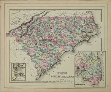
Sold20211887 Mitchell Map of North and South Carolina -- NorthTitle: 1887 Mitchell Map of North and South Carolina -- North and South Carolina Cartographer: S Mitchell Year / Place: 1887, Philadelphia Map Dimension (in.): 11.3 X 14 in. A very nice map of the CarSee Sold Price
Sold20211884 Mitchell Map of North and South Carolina -- NorthTitle: 1884 Mitchell Map of North and South Carolina -- North and South Carolina Cartographer: S Mitchell Year / Place: 1884, Philadelphia Map Dimension (in.): 11.3 X 14 in. This is a very nice map ofSee Sold Price
Sold2023Rare Giles Croom Signed Crawford Co. 1gal JugSought after Giles Croom ( Born 1832 in North Carolina ) "C' Crawford Co. 1gal Jug this is a very scarce example due to mark only a handful known and this one is a different example due to the conditiSee Sold Price
Sold2022Six 19th Century Maps of North and South Carolinasix maps, engravings on wove paper, some with hand colored highlights, all unframed, including: three examples of Frank Gray, Gray's New Map of North and South Carolina, Philadelphia, circa 1881; JohnSee Sold Price
Sold2019Scarce 1848 map of Tennessee - S. A. MitchellReserve Reduced! Nice clean example of this early map of Tennessee. Has a copyright date of 1846 but it’s from the 1848 edition of Mitchell's New Universal Atlas. The 1848 edition shows the additionSee Sold Price
Sold2016S. Mitchell: North and South Carolina, 1871Map: North and South Carolina Cartographer: S Mitchell Publishing: Philadelphia, 1871 (marked 1850) Size: 11.3 x 14 inches A very nice map of the Carolinas, showing via color-coding the individual couSee Sold Price
May 15University ArchivesScarce Early Printing: "An Account of the European Settlement in America in 6 Parts..."$100
May 09Rail & Road AuctionsChicago, North Shore & Milwaukee Railroad North Shore Line Playing Cards Complete$50
May 15University ArchivesEarly Arctic Exploration: "Journal of a Voyage for the Discovery of a North-West Passage" by William$500
5 days LeftLeland LittleTommy Mitchell (North Carolina, 20th/21st Century), Custom Hanging Cabinet$50


![[Confederate] Sword & Effects of North Carolina Officer (1 of 16)](https://p1.liveauctioneers.com/7226/325455/175169159_1_x.jpg?height=282&quality=70&version=1712370394)
![[Gettysburg POW] 57th North Carolina Portrait (1 of 2)](https://p1.liveauctioneers.com/7226/325455/175169163_1_x.jpg?height=282&quality=70&version=1712370394)
![[Confederate] Portrait of North Carolina Officer (1 of 2)](https://p1.liveauctioneers.com/7226/325455/175169161_1_x.jpg?height=282&quality=70&version=1712370394)


