Sold2021Nolan, Edward C1880 Map of Eastern HemisphereSteel Engraved Map Published C1880, London for "The Illustrated History of the British Empire in India and the East" by Edward H. Nolan. Centre fold as issued. Paper Size: 12 x 10 inch (30 x 25cm) SmaSee Sold Price
Sold2019Nolan, Edward C1880 Map of The Eastern HemisphereSteel Engraved Map Published C1880, London for "The Illustrated History of the British Empire in India and the East" by Edward H. Nolan. Centre fold as published. Paper Size: 12.5 x 9.5 inch (32 x 24cSee Sold Price
Sold2023Nolan & Hughes C1880 Antique Map. Eastern HemisphereLithograph Map Published C1880, London for "The Illustrated History of the British Empire in India and the East" by Edward H. Nolan. Centre fold as issued. Drawn by W. Hughes. Paper Size: 12 x 10 inchSee Sold Price
Sold2021Nolan, Edward C1880 Map of The East India IslandsSteel Engraved Map Published C1880, London for "The Illustrated History of the British Empire in India and the East" by Edward H. Nolan. Centre fold as issued. Paper Size: 12 x 10 inch (30 x 25cm) GooSee Sold Price
Sold2021Nolan, Edward C1880 Decorative Map of IndiaSteel Engraved Map Published C1880, London for "The Illustrated History of the British Empire in India and the East" by Edward H. Nolan. Centre fold as issued. Paper Size: 12 x 10 inch (30 x 25cm) GooSee Sold Price
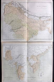
Sold2021Nolan, Edward C1880 Pair of Maps of India"India. The Bombay Presidency/India. The Madras Presidency" and "India The Bengal Presidency" Steel Engraved Map Published C1880, London for "The Illustrated History of the British Empire in India andSee Sold Price
Sold2021Nolan, Edward C1880 Lot of 3 Maps. China, Japan, AsiaSteel Engraved Map Published C1880, London for "The Illustrated History of the British Empire in India and the East" by Edward H. Nolan. Centre fold as issued. Paper Size: 12 x 10 inch (30 x 25cm) GooSee Sold Price
Sold2019Japan C1880 Pair of Maps by Nolan & Blackie"The Islands of Japan with Corea..." Steel Engraved Map Published C1880, London for "The Illustrated History of the British Empire in India and the East" by Edward H. Nolan. Centre fold as published.See Sold Price
Sold2021Tallis, John (Pub) 1852 Map. Eastern HemisphereSteel Engraved Map with Original Outline Hand Color Published 1852-56 by John Tallis, London for "The Universal Pronouncing Dictionary" by Thomas Wright. Drawn & Engraved by John Rapkin. Centre fold aSee Sold Price
Sold2024Taylor, Ruth 1935 Vintage Cartoon Map. Eastern HemisphereVintage Lithograph Map Published 1935, Boston for "Our U. S. A. A Gay Geography" By Frank Taylor. Maps by Ruth Taylor. Paper Size: 12.5 x 9.5 inch (32 x 24cm) Tight margin as split from the larger sheSee Sold Price
Sold2022Hughes, William C1865 Map. Eastern HemisphereSteel Engraved Map Published C1865 London for "The History of England..." By David Hume, Tobias Smollett and others. Drawn and Engraved by William Hughes. Centre fold as published. Paper Size: 13.5 xSee Sold Price
Sold2019Nolan, Edward C1880 Lot of 6 Prints of IndiaSteel Engravings Published C1880, London for "The Illustrated History of the British Empire in India and the East" by Edward H. Nolan. Centre fold as published. Paper Size: 10 x 5 inch (25 x 16cm) VerSee Sold Price
Sold2022Barclay, James C1800 Map. Eastern HemisphereCopper Engraved Map Published C1800 Halifax & Newcastle, England for "Barclay's Universal English Dictionary…" by James Barclay. Maps Engraved by Clerk, Milton and others. Paper Size: 10 x 8 inch (2See Sold Price
Sold2021Nolan, Edward C1880 Lot of 8 India Related PortraitsSteel Engraving Published C1880, London for "The Illustrated History of the British Empire in India and the East" by Edward H. Nolan. Paper Size: 10 x 7 inch (25 x 18cm) Good Condition overallSee Sold Price
Sold2021Nolan, Edward C1880 Lot of 8 India Related PortraitsSteel Engraving Published C1880, London for "The Illustrated History of the British Empire in India and the East" by Edward H. Nolan. Paper Size: 10 x 7 inch (25 x 18cm) Good Condition overallSee Sold Price
Sold2023Thomson, John (Pub) 1825 Map. Eastern HemisphereCopper Engraved Map Published 1825 by John Thomson, Edinburgh for "The Edinburgh School Atlas" by N. R. Hewitt. Maps Engraved by Hewitt. Original Outline Hand Colour. Rare. Paper Size: 10.5 x 8 inch (See Sold Price
Sold2022Hughes, William C1865 Map. Eastern HemisphereSteel Engraved Map Published C1865 London for "The History of England..." By David Hume, Tobias Smollett and others. Drawn and Engraved by William Hughes. Centre fold as published. Paper Size: 13.5 xSee Sold Price
Sold2023Nolan, Edward C1880 Lot of 9 Views & Scenes of IndiaSteel Engraving Published C1880, London for "The Illustrated History of the British Empire in India and the East" by Edward H. Nolan. Paper Size: 10 x 7 inch (25 x 18cm) Some toning in parts. Good ConSee Sold Price
Sold2023Nolan, Edward C1880 Lot of 6 India Prints. Battles, ScenesSteel Engraving Published C1880, London for "The Illustrated History of the British Empire in India and the East" by Edward H. Nolan. Paper Size: 10 x 7 inch (25 x 18cm) A couple of minor faults. GoodSee Sold Price
Sold2023Nolan, Edward C1880 Lot of 4 Views of IndiaSteel Engraving Published C1880, London for "The Illustrated History of the British Empire in India and the East" by Edward H. Nolan. Paper Size: 10 x 7 inch (25 x 18cm) A couple of minor faults. GoodSee Sold Price
Sold2023Nolan, Edward C1880 Lot of 6 India Related PortraitsSteel Engraving Published C1880, London for "The Illustrated History of the British Empire in India and the East" by Edward H. Nolan. Paper Size: 10 x 7 inch (25 x 18cm) Minor toning in parts, OtherwiSee Sold Price
Sold2021Pinnock & Archer 1833 Map. Eastern HemisphereWoodblock Published 1833, London for "The Guide to Knowledge" Edited by W. Pinnock. Maps by Joshua Archer. Reverse side blank. Paper Size: 10.5 x 7.5 inch (27 x 19cm) Good ConditionSee Sold Price
Sold2023Nolan, Edward C1880 Lot of 4 Views of IndiaSteel Engraving Published C1880, London for "The Illustrated History of the British Empire in India and the East" by Edward H. Nolan. Paper Size: 10 x 7 inch (25 x 18cm) A couple of minor faults. GoodSee Sold Price
Sold2022Barclay, James 1813 Half Map. Eastern HemisphereCopper Engraved Map Published 1812-13 by Brightly & Childs, Bungay for "A Complete and Universal Dictionary of the English Language..." by the Rev. James Barclay. Outline hand colour as issued. Most mSee Sold Price
2024Jasper52Eastern Europe Italian Albania Czechosolvakia Carpathian Ruthenia TIMES 1922 mapSee Sold Price
2 days LeftAlbion AuctionsStanford, Edward 1901 Large Map. Balkan Peninsula. Greece Turkey Macedonia$5
14 hrs LeftZikorn Arts & History ObjectsWest Indies, Eastern Cuba 1881 British Admiralty Nautical Map$100
13 hrs LeftPotter & Potter AuctionsTUNIS, Edward (1897 – 1973). From Chesapeake Bay / Land of ...$250
May 30Forum AuctionsGeorge Pitt-Rivers' copy.- Homosexuality.- Carpenter (Edward) Intermediate Types among Primitive£300
May 30Forum AuctionsAngling.- Minhinnick (Sir Gordon Edward George) Collection of 14 original illustrations and 20£400
2 days LeftAlbion AuctionsPaterson & Mogg C1830 British Road Map. Cumberland, Westmorland & Lancashire$5(1 bid)
Jun 12Dan Morphy AuctionsGEOLOGY OF THE BLACK AND GRAND RAPIDS OF TEXAS INCLUDING THE EASTERN AND WESTERN CROSS TIMBERS,$100
2024Jasper52Corso del Danubio da Belgrado fino al Mar Ner. Danube. ROSSI / CANTELLI 1684 mapSee Sold Price
7 days LeftJasper52Suite de l’Ocean Oriental…' East Asia/Indies. Western Pacific. BELLIN 1746 map$200
2 days LeftAlbion AuctionsPaterson & Mogg C1830 British Road Map. New Shorehamd to Chichester to Fareham$5(1 bid)
2 days LeftAlbion AuctionsPaterson & Mogg C1830 British Road Map. Banks of the River Wye. Chepstow etc$5(1 bid)


![[BOOKS] WESTERN PHOTOGRAPHERS. LOT OF 4 VOLS (1 of 4)](https://p1.liveauctioneers.com/8124/329546/177689840_1_x.jpg?height=282&quality=70&version=1715469494)


