Sold20241639 Jan Jansson Antique Map of North America Virginia to New York to New EnglandThis beautifully hand coloured, important original antique map of the north east regions of the United States from Virginia, Chesapeake Bay, to New York & New England by Jan Jansson was published in tSee Sold Price
Sold2019CANADIAN ARCTIC ARCHIPELAGO. 'Arctic Regions of NorthReserve Reduced! TITLE/CONTENT OF MAP: 'The Arctic Regions of North America; Inset map of Kennedy Chan' DATE PRINTED: 1863 IMAGE SIZE: Approx 31.0 x 43.0cm, 12.25 x 17 inches (Large) TYPE: Antique mapSee Sold Price
Sold2018Stackhouse: Antique Map Ancient Germanic Regions, 1783Title/Content of Map: Ancient Germanic Regions by Stackhouse Date Printed: 1783 Cartographer: Thomas Stackhouse Material/Medium: Paper Size: 16" x 20" Original hand color, copperplate engraved. PublisSee Sold Price
Sold2018Mallet: Antique Map of France in Regions, 1683TITLE OF THE MAP: 'France' DATE PRINTED: 1683 IMAGE SIZE: Approx Overall page size 13 x 21cm approximately (5 x 8 inches); image size 10.5 x 14.5cm approximately (4 x 5.5 inches) TYPE: Original 17th cSee Sold Price
Sold2017Mawman: Antique Map Plan of Athens, Greece, 1791Original copper engraving from the 1791 "Maps, Plans, Views, and Coins Illustrative of the Travels of Anacharsis the Younger in Greece". by J. Mawman, 1805. Plan of the Academy & Environs for the travSee Sold Price
Sold2017Mawman: Antique Map Plan of Athens, Greece, 1791Original copper engraving from the 1791 "Maps, Plans, Views, and Coins Illustrative of the Travels of Anacharsis the Younger in Greece". by J. Mawman, 1805. Plan of the Athens for the travels of AnachSee Sold Price
Sold2017Mawman: Antique Map Plan of Athens, Greece, 1791Original copper engraving from the 1791 "Maps, Plans, Views, and Coins Illustrative of the Travels of Anacharsis the Younger in Greece". by J. Mawman, 1805. Plan of the Athens for the travels of AnachSee Sold Price
Sold2017Mawman: Antique Map of Plan of a Grecian Palestra, 1791Title/Content of Map: Greece: Plan of a Grecian Palestra after Vitruvius, 1791 Date Printed: 1791 Cartographer: J. Mawman Material/Medium: Engraving Size: 10 1/4" x 15 1/4" Original copper engraving fSee Sold Price
Sold2018Seutter: Antique Map of East Prussia, 1740Title/Content of Map: Today's northern Poland. East Prussia. Poland and Baltic regions by Seutter Date Printed: c1740 Cartographer: Mattaus Seutter Material/Medium: Paper Size: 19" x 23" Original handSee Sold Price
Sold2018Seutter: Antique Map of Brandenburg & Pomerania, 1740Title/Content of Map: Brandenburg & Pomerania region of Germany & Poland Date Printed: c1740 Cartographer: Matthaus Seutter Material/Medium: Paper Size: 19 1/2" x 23 3/4" Original hand colored copperpSee Sold Price
Sold2017Zimmerman: Antique Arctic World Discoveries Book, 1804Map: Taschenbuch der Reisen/Die Westliche Arktische Welt Cartographer: E.A.W. von Zimmerman Place & Date: Leipzig / 1804 Size: 3 3/8" x 4 7/8" (overall volume) Condition: original binding, worn and scSee Sold Price
Sold2024John Speed 1676 Original Antique Map of Virginia and Maryland No ColorAntique 1676 map of Virginia and Maryland engraved by Francis Lamb and republished by Thomas Basset & Richard Chriswell after John Speed's 1611 atlas. With "The Description of Mary-Land" text on reverSee Sold Price
Sold20221747 Mexico, California, New Mexico, Texas Original Antique Map by Emanuel Bowen1747 Mexico, California, New Mexico, Texas Original Antique Map by Emanuel BowenSee Sold Price
Sold2022LAPIE ORIGINAL ANTIQUE MAP ASIA MINOR 1831L' ASIE MINEURE 1831 SIZE: 25.5 X 20 INCHES APPROX. UNFRAMEDSee Sold Price
Sold2021LAPIE ORIGINAL ANTIQUE MAP ALGERIA TUNISIA TRIPOLI 1829Original Carte De La Barbarie -Maroc - D'Alger, De Tunis, De Tripoli 1829 SIZE: 25.5 X 20 INCHES APPROX. UNFRAMEDSee Sold Price
Sold2024Original Antique Map of China, Macau and Canton - Asia - Jacques Nicolas BellinIts finely engraved, hand-coloring engraved map from the Dutch edition of acques Nicolas Bellin Histoire General des Voyages. Published in Amsterdam, 1770 year. This fine copperplate map from that ediSee Sold Price
Sold2022Original Antique Map -Pommern Provinz - Map of Bornholm Island Baltic SeaAntique outline hand colored map from edition of Meyer’s world atlas, edited by Ludwig Ravenstein, published by Bibliographic Institute in 1872. Technique: Engraving. Place: Leipzig, Germany. SSee Sold Price
Sold2022Original Antique Map - Mecklenburg-Schwerin - Map of Northern GermanyAntique outline hand colored map from edition of Meyer’s world atlas, edited by Ludwig Ravenstein, published by Bibliographic Institute in 1872. Technique: Engraving. Place: Leipzig, Germany. SSee Sold Price
Sold2022Original Antique Map -Bremen Oldenburg - Map of Bremen OldenburgAntique outline hand colored map from edition of Meyer’s world atlas, edited by Ludwig Ravenstein, published by Bibliographic Institute in 1872. Technique: Engraving. Place: Leipzig, Germany. SSee Sold Price
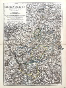
Sold2022Original Antique Map -Hessen Nassau - Map of Furstenthum WaldeckAntique outline hand colored map from edition of Meyer’s world atlas, edited by Ludwig Ravenstein, published by Bibliographic Institute in 1872. Technique: Engraving. Place: Leipzig, Germany. SSee Sold Price
Sold2022Original Antique Map - Konicreich Bohmen - Map of Bohmen - Prague - CarlsbadAntique outline hand colored map from edition of Meyer’s world atlas, edited by Ludwig Ravenstein, published by Bibliographic Institute in 1872. Technique: Engraving. Place: Leipzig, Germany. SSee Sold Price
Sold2017Mitchell: Plan of BostonMap: Plan of Boston (original Antique map) Maker/Publisher: S. Augustus Mitchell Publishing Date: 1872 Size: 13.5 x 20.75 inches Hard-to-find 1872 Mitchll map of Boston in the more unusual 2-page formSee Sold Price
Sold20191867 NORTH + SOUTH CAROLINA MAPOriginal antique map of North and South Carolina published by S. Augustus Mitchell, Jr. Includes inset maps of Charleston Harbor in the bottom left and a Plan of Charleston in the bottom right. It feaSee Sold Price
Sold2022Scarce 1695 map of Wilt Shire with Stone Henge by Robert MordenScarce copper engraved original antique map by Robert Morden from the 1695 Atlas to Accompany Camden’s Britannia with decorative cartouche and enhanced with later hand coloring. Stone Henge circSee Sold Price
May 15Jasper52l'Arménie, la Géorgie et la Daghistan Caucasus. SANTINI/RIZZI-ZANNONI 1784 map$120
Featured7 days LeftJasper52Mitchell’s Map of Asia showing travel routes London, India, China & Japan, 1860$45
Featured13 hrs LeftJasper52JAMAICA & HAITI. 'Hayti'. Caribbean West Indies. WELLER 1863 old antique map$35
13 hrs LeftJasper52GUADELOUPE. Marie-Galante, Désirade, Iles des Saintes.Vuillemin. 1903 old map$15
13 hrs LeftJasper52GUADELOUPE & MARIE-GALANTE. Soufrière. Dugommier. Antilles. VUILLEMIN 1879 map$25