Sold2023EARLY COLONIAL AFRICA pre Scramble for Africa. Mountains of Kong. LETTS 1883 mapTITLE/CONTENT OF MAP: 'Letts's General map of Africa; Inset map of British Isles' Shows the non-existent Mountains of Kong DATE PRINTED: 1883 IMAGE SIZE: Approx 36.0 x 42.5cm, 14 x 16.75 inches (LargeSee Sold Price
Sold2023EARLY COLONIAL AFRICA pre Scramble for Africa. Mountains of Kong. LETTS 1884 mapTITLE/CONTENT OF MAP: 'Letts's General map of Africa; Inset map of British Isles' Shows the non-existent Mountains of Kong DATE PRINTED: 1884 IMAGE SIZE: Approx 36.0 x 42.5cm, 14 x 16.75 inches (LargeSee Sold Price
Sold2024SOUTH CENTRAL AFRICA. Shows Zambesi river as circular! WELLER 1863 old mapTITLE/CONTENT OF MAP: 'South Central Africa' The map shows early colonial Africa, with the variable hand coloured outline of the continent indicating early claims. The Zambesi river has not been fullySee Sold Price
Sold2020Pre-colonial AFRICA. Mountains of Kong.CircularTITLE/CONTENT OF MAP: 'Africa' This fascinating map of early colonial Africa includes a number of cartographic errors or misapprehensions. These include the non-existent "Mountains of Kong" in West AfSee Sold Price
Sold2024Pre-colonial Africa. Mountains of Kong/Moon. Caravan routes. THOMSON 1817 mapTITLE/CONTENT OF MAP: 'Africa' This wonderful large map shows Africa at the start of the colonial era, when it was still substantially unexplored by Europeans. The substantial blank area in the centreSee Sold Price
Sold2024Pre-colonial Africa. Mountains of Kong/Moon. Caravan routes. THOMSON 1817 mapTITLE/CONTENT OF MAP: 'Africa' This wonderful large map shows Africa at the start of the colonial era, when it was still substantially unexplored by Europeans. The substantial blank area in the centreSee Sold Price
Sold2023AFRICA pre most European exploration/colonisation. Kong Mountains. SDUK 1857 mapTITLE/CONTENT OF MAP: 'AFRICA' Much of Central Africa was unexplored by Europeans in 1857 and is therefore shown as blank on the map. Lake Victoria was first sighted by a European in 1858. The map shoSee Sold Price
Sold2019AFRICA. Shows Mountains of Kong/the Moon. CaravanTITLE/CONTENT OF MAP: 'Africa' The map shows a number of tribal and early colonial territories, mostly delineated inland from the coast but with unresolved borders. The Maghreb is described evocativelSee Sold Price
Sold2019AFRICA. Shows Mountains of Kong/the Moon. CaravanTITLE/CONTENT OF MAP: 'Africa' The map shows a number of tribal and early colonial territories, mostly delineated inland from the coast but with unresolved borders. The Maghreb is described evocativelSee Sold Price
Sold2024AFRICA shows 1911 Neukamerun border changes. Equatorial cross section 1912 mapTitle: AFRICA shows 1911 Neukamerun border changes. Equatorial cross section 1912 map Description: Africa; Inset maps of Ascension; St. Helena; Mauritius; Section across Equatorial Africa' by John BarSee Sold Price
Sold2022Rare 1836 Col. Dodge Expedition map - 1st printing, SteenLarge and important early copper engraved map of the western U. S. showing the route of Col. Henry Dodge’s 1835 Expedition from Fort Leavenworth to the Rocky Mountains. Rare first printing withSee Sold Price
Sold2022Spectacular Buerman Snake SpursA phenomenal pair of very early single inlaid spurs with cut-out snake heelbands, and deeply chased iron offsides. In stunning condition with original blue finish showing, early AB star mark, and wondSee Sold Price
Sold2022Amazing Massive Navajo WeavingAn incredible very large Navajo sampler style rug showing many Ganado and Klagetoh characteristics. It boasts the typical geometric patterns of these woven pieces of art of small weavings inset withinSee Sold Price
Sold2020Sioux Matching Possible BagsMagnificent pair of hide bags with beautiful early beadwork that includes greasy yellow, cobalt blue, and re white heart beads, along with extensive quill work and multiple decorative tinckle cones. ASee Sold Price
Sold2020Canon City Prison SpursStunning pair of unmarked John Cox engraved Canon City prison made spurs, incredible massive size, double mounted, with wide scalloped heelbands, inlaid chap gaurds, striking unusual silver strap buttSee Sold Price
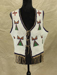
Sold2022Plains Indian Beaded VestOutstanding 1890's men's beaded vest with tremendous full coverage beadwork, having pleasing geometric pattern and uncommon bottom finger. Size approximately 38.See Sold Price
Sold2022Pre-colonial Gold Mask from Butuan/Surigao, 10th – 14th CenturiesPre-colonial Gold Maskfrom Butuan/Surigao, 10th – 14th Centuries 22k gold mounted on to 420 grams of Sterling Silver Chainmailwith Sterling Silver Frame, solid Balayong Base 22 1/2" x 7 1/2" xSee Sold Price
Sold2021A COLONIAL MAP, "Carte de la Louisiane et du Cours duA COLONIAL MAP, "Carte de la Louisiane et du Cours du Mississipi," PARIS, JUNE 1718, hand colored engraving on paper, "Dressée sur un grand nombre de Mémoires entr'autres sur ceux de Mr. le Maire paSee Sold Price
Sold2021Sydney Lawrence, oil on canvas on boardSydney Lawrence, oil on canvas on board, Sydney Mortimer Lawrence (American, 1865-1940), Western Mountain Landscape, signed lower right, 9"h x 13.5"w (sight), 14.5"h x 18.5"w (frame) Provenance: A PriSee Sold Price
Sold2023Western NC Mountain Landscape with Wagon and Figures, Hudson River School StyleAmerican School, Western North Carolina, mid 19th century oil on canvas landscape painting from the Asheville, NC region depicting a view of mountains in the background and a rocky cliffside to the leSee Sold Price
Sold2024East Africa safari map. Game Reserves National Parks. Uganda Kenya Tanzania 1971Title: East Africa safari map. Game Reserves National Parks. Uganda Kenya Tanzania 1971 Description: East Africa [Kenya, Tanzania, Uganda] by Hameed Moghul (The publication date of the map is given bySee Sold Price
Sold2019Rare GEORGE JONES Majolica Centerpiece "Africa"Very Rare Majolica GEORGE JONES Centerpiece/Compote from the Continents Series, "Africa". It shows a Lion and Lioness under a tree with a Lizard hiding under a burrow. c. 1874 this is one of the fourSee Sold Price
Jun 14DuMouchellesWilliam H. Gamble (American, B. 1863) Hand Colored Engraving, Ca. 1863, "County Map of Michigan And$50(1 bid)
1 day LeftHolabird Western Americana CollectionsSanitary & Topographical "Viele Map" of Manhattan 1865 [182838]$750
Jul 14Schilb Antiquarian Rare Books1858 History of Virginia Jamestown Powhatan INDIANS John Smith SLAVERY Cabot$1
1 hr LeftHolabird Western Americana CollectionsJohn Fremont Library of Books (6) c1845-1970 [179374]$500
1 hr LeftHolabird Western Americana CollectionsCalifornia Diaries & Letters Pre-Gold Rush, 1820-1840 [183984]$100
1 hr LeftHolabird Western Americana CollectionsWestern Missions and Missionaries, De Smet, 1859 [182513]$120
BonhamsHARRIS (WILLIAM CORNWALLIS) Narrative of an Expedition into Southern Africa, During the Years 18...£600
1 hr LeftHolabird Western Americana CollectionsRush to the Rockies "Pikes Peak or Bust!" by Nora A. Slifer, 12 Boxes [166315]$500
1 hr LeftHolabird Western Americana CollectionsScenery of California by Langworthy 1850s [181895]$250
Jul 14Schilb Antiquarian Rare Books1819 COLUMBUS 1ed America Magellan USA Washington Cortez MAPS Revolutionary War$1
1 day LeftEthnika Home Decor & AntiquesRare Baule Portrait Head Mask / Helmet Mblo Kpan - Cote d'Ivoire - Africa 11" In. High$250
7 days LeftJulien's AuctionsE.T. the Extra Terrestrial | Universal Studios Japan "E.T. Adventure" Animatronic$5,000
BonhamsAFRICA MUNSTER (SEBASTIAN) Africa Lybia Morenlandt mit allen königreichen so zu unsern zeit...£300
Jun 15Hess Fine AuctionsPost-Colonial John Harrison Liverpool 18K Gold Mens Import Open Face Key Wind Chain Drive Pocket Wat$1,300(1 bid)
2 days LeftEarly American History Auctions1720 Colonial Northumberland County Virginia Manuscript Deed and Map Plot$400
Jun 23Schilb Antiquarian Rare Books1890 Livingstone 1ed In Darkest Africa Henry Stanley Emin Pasha Expedition MAP$115(8 bids)
1 hr LeftHolabird Western Americana CollectionsFar West & Rockies Series Vol I-XIV, Hafen, 1954-1960 [182451]$750(1 bid)


![East Africa safari map. Game Reserves National Parks. Uganda Kenya Tanzania 1971: Title: East Africa safari map. Game Reserves National Parks. Uganda Kenya Tanzania 1971 Description: East Africa [Kenya, Tanzania, Uganda] by Hameed Moghul (The publication date of the map is given by](https://p1.liveauctioneers.com/5584/330582/178266232_1_x.jpg?height=310&quality=70&version=1716924723)

![Foreign Interest Books c1863-1906 (4) [179682] (1 of 9)](https://p1.liveauctioneers.com/2699/331494/178785475_1_x.jpg?height=282&quality=70&version=1717094654)

![Sanitary & Topographical "Viele Map" of Manhattan 1865 [182838] (1 of 3)](https://p1.liveauctioneers.com/2699/331495/178785766_1_x.jpg?height=282&quality=70&version=1717094933)

![John Fremont Library of Books (6) c1845-1970 [179374] (1 of 7)](https://p1.liveauctioneers.com/2699/331494/178785501_1_x.jpg?height=282&quality=70&version=1717094654)
![Arizona History Book Duo [182375] (1 of 6)](https://p1.liveauctioneers.com/2699/331494/178785507_1_x.jpg?height=282&quality=70&version=1717094654)
![California Diaries & Letters Pre-Gold Rush, 1820-1840 [183984] (1 of 0)](https://p1.liveauctioneers.com/dist/images/placeholder.jpg?height=282&quality=70)
![Western Missions and Missionaries, De Smet, 1859 [182513] (1 of 5)](https://p1.liveauctioneers.com/2699/331494/178785631_1_x.jpg?height=282&quality=70&version=1717094654)

![Rush to the Rockies "Pikes Peak or Bust!" by Nora A. Slifer, 12 Boxes [166315] (1 of 7)](https://p1.liveauctioneers.com/2699/331494/178785592_1_x.jpg?height=282&quality=70&version=1717094654)
![Scenery of California by Langworthy 1850s [181895] (1 of 4)](https://p1.liveauctioneers.com/2699/331494/178785448_1_x.jpg?height=282&quality=70&version=1717094654)


![[MAP]. ORTELIUS, Abraham. Africae Tabula Nova. 1592. (1 of 2)](https://p1.liveauctioneers.com/197/329395/177650533_1_x.jpg?height=282&quality=70&version=1715364962)


![Far West & Rockies Series Vol I-XIV, Hafen, 1954-1960 [182451] (1 of 6)](https://p1.liveauctioneers.com/2699/331494/178785563_1_x.jpg?height=282&quality=70&version=1717094654)