Sold2023Rand, McNally & Co.'S Indexed County and Township Pocket Map And Shippers' Guide of Maryland AndPublication Date: c1886 Title: Rand, McNally & Co.'S Indexed County and Township Pocket Map And Shippers' Guide of Maryland And Delaware Cartographer: RAND, MCNALLY & CO. Publisher: RAND, MCNALLY & COSee Sold Price
Sold2017Rand McNally Pocket Map & Shippers Guide of Alaska 1912Map: Rand, McNally & Co.'S Indexed County and Township Pocket Map And Shippers' Guide of Alaska Publication Date: 1912 Author: RAND, MCNALLY & COMPANY, RAND, MCNALLY & CO. Publisher: RAND, MCNALLY & CSee Sold Price
Sold2020Rand McNally & Co., County and Railroad Pocket MapRand McNally & Company, Indexed County and Railroad Pocket Map and Shipper's Guide of Texas, Chicago 1904 image size: 24 x 16", frame: 28 x 17.5" Fine separately published map of Texas, colored by couSee Sold Price
Sold2021Rand, McNally & Co.'s Wyoming.Publication Date: 1909 Title: Rand, McNally & Co.'s Wyoming. Publisher: Rand, McNally & Co. Height: 12.5 Width:18.8 In: Rand, McNally & Co.'s indexed county and township Pocket Map and Shippers' GuideSee Sold Price
Sold2021Rand, McNally & Co.Publication Date: 1906 Title: Rand, McNally & Co.'s Indexed County and Railroad Pocket Map And Shippers' Guide of Kentucky Cartographer: RAND, MCNALLY & CO. Publisher: RAND, MCNALLY & CO. Paper coversSee Sold Price
Sold2020RAND MCNALLY & CO'S POCKET MAP AND SHIPPERS GUIDE TORAND MCNALLY & CO'S POCKET MAP AND SHIPPERS GUIDE TO ILLINOIS (showing the ) ENTIRE RAILROAD SYSTEM, post offices, islands, lakes, river, etc. 4x6.5” big fold out map. Copyright 1893. 95 railroaSee Sold Price
Sold2018Colorado Rand, McNally Indexed Pocket Map Tourists' AndTitle: Colorado Rand, McNally Indexed Pocket Map Tourists' And Shippers' Guide Publication Date: 1924 Cartographer: RAND, MCNALLY & CO. Publisher: RAND, MCNALLY & CO. Size: 19X25.8 Map with 42 pp indeSee Sold Price
Sold2020Shipper's Guide of Iowa, Rand McNally, 1892 (111605)Was supposed to include pocket map, but no map. Still has information on the businesses of Iowa in 1892. 45 pp. Provenance: John Reynolds Collection Country (if not USA): State: Iowa City/County: DateSee Sold Price
Sold2019Rand-McNally New Commercial Atlas map of FloridaTitle: Rand-McNally New Commercial Atlas map of Florida Date: ©1916 Cartographer: Publisher: RAND-MCNALLY & COMPANY Size: 18.75Height - 25.75Width Laid into: Rand-McNally Indexed Pocket Map and ShippSee Sold Price
Sold2021Street Guide Map of ChicagoStreet Guide Map of Chicago, signature to the right reads ‘RAND, McNALLY & COMPANY’S INDEXED ATLAS OF THE WORLD’, verso reads ‘Rand McNally Chicago 1898’, A.I. Friedman’, subject detailedSee Sold Price
Sold2020Antique (1895) Rand McNally Pocket Map of Maryland and4 1/4 x 6 1/2 inches; aÊbeautifully maintained, comprehensive representation showing the entire railroad system throughout Maryland, D.C. and DelawareSee Sold Price
Sold20221891 Rand-McNally Pocket Map of West Virginia & Otherrated 7 & 8, 6"x4", West Virginia is slightly soiled and has wear, other is Saskatchewan date is unknown is nice.See Sold Price
Sold2019West Indies Rand, McNally & Co.'S Indexed Atlas Map ofTitle/Content of Map: West Indies Rand, McNally & Co.'S Indexed Atlas Map of the World Map of the West Indies. Date: 1898 Cartographer: RAND, MCNALLY & CO. Publisher: RAND, MCNALLY & CO. Size: 12.3HeiSee Sold Price
Sold2020Rand, McNally & Co.'S Guide Map of New York CityTitle: Rand, McNally & Co.'S Guide Map of New York City Publication Date: 1895 Cartographer: RAND, MCNALLY & CO. Publisher: RAND, MCNALLY & CO. Size: 26 x 24.5 Description: NYC Guide Map With Large InSee Sold Price
2018Rand, McNally & Co.'S Guide Map of New York CityTitle: Rand, McNally & Co.'S Guide Map of New York City Date: 1895 Cartographer: RAND, MCNALLY & CO. Size: 26 X 24.5 With large inset of Central Park. Fold repairs. NYC Guide Map With Large Inset of CSee Sold Price
Sold2018Rand-McNally Indexed Atlas. Philippine IslandsTitle/Content of Map: Rand-McNally Indexed Atlas. Philippine Islands Date: 1904 ca. Cartographer: RAND, MCNALLY & CO. Size: 26 X 19 Page xxii, xxiii from Rand, McNally & Co.'s Enlarged business atlasSee Sold Price
Sold2016Rand, McNally & Co. Indexed State and Railroad Map ofRand, McNally & Co. Indexed State and Railroad Map of Mexico. Chicago - New York, 1892. Folded map. Atlas of the World Map of MexicoSee Sold Price
Sold2017Rand McNally: Indexed Atlas of the World Map of EuropeMap: Rand, McNally & Co.'S Indexed Atlas of the World Map of Europe. Publication Date: 1892 Authors: RAND, MCNALLY & CO., RAND, MCNALLY & CO. Publisher: RAND, MCNALLY & CO. Size: Folio – 19.00 H x 2See Sold Price
Sold2023Scarce early McNally map of Georgia - 1881Early and scarce 1881 Rand McNally Indexed Atlas of the World map of Georgia. Highly detailed, showing counties, towns, rivers, mountains, lakes, roads, railroads, stations, swamps, topography, etc. PSee Sold Price
Sold2018Group of Four Vintage American Pocket Maps[Maps] Group of Four Vintage American Pocket Maps. Chicago: Rand McNally, 1913 – 14. Including California, Alabama, Washington and Oregon. Brown paper wraps. Pictorial ads, fold out color maps.See Sold Price
Sold2018Rand, McNally & Co.'s Indexed Atlas of the World Map ofTitle/Content of Map: Rand, McNally & Co.'s Indexed Atlas of the World Map of New York City Date: 1892 Cartographer: RAND, MCNALLY & CO. Size: 26X19 Pages 62-63 in Rand, McNally & Co.'s Indexed atlasSee Sold Price
Sold2018Rand, McNally & Co.'S Indexed Atlas of the World Map ofReserve Reduced! Title/Content of Map: Rand, McNally & Co.'S Indexed Atlas of the World Map of Japan.Date: 1892 Cartographer: RAND, MCNALLY & CO. Material/Medium: RAND, MCNALLY & CO. Size: 19 x 25.8 iSee Sold Price
Sold2018Rand, McNally & Co.'S Indexed Atlas of the World Map ofTitle/Content of Map: Rand, McNally & Co.'S Indexed Atlas of the World Map of Philadelphia. Date: 1892 Cartographer: RAND, MCNALLY & CO. Size: 19X25.75 Pages 62-63 in Rand, McNally & Co.'s Indexed atlSee Sold Price
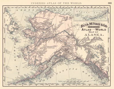
Sold2024Rand, McNally & Co.'S Indexed Atlas of the World Map of AlaskaTitle:Rand, McNally & Co.'S Indexed Atlas of the World Map of Alaska Publication Date: 1892 Cartographer:RAND, MCNALLY & CO. Publisher: RAND, MCNALLY & CO. Height: 9.3 Width: 11.8 Map showing AK withSee Sold Price
BonhamsBRADFORD (THOMAS G.) A Comprehensive Atlas, Geographical, Historical & Commercial, 1835; and atl...£500
Jul 13Cain Modern AuctionsDouble Sided U.S. Map by Rand McNally, Illustrated & Equal Area Projection$70
Jun 27Rail & Road Auctions32 Pieces of Eastern and Canadian Railroad Paper - Erie, Erie Lackawanna, Canadian National,$20
Jun 27Rail & Road Auctions54 Pieces of Pennsylvania Railroad Ephemera - Pocket Calendars, Maps, Aluminum Coins, etc$20(1 bid)
BonhamsIRELAND - IRISH BIBLE [New Testament] Tiomna nuadh ar dtighearna agus slanaightheora iosa criosd...£360
Jun 28South Florida Auction & Estate Sale Services IncWW2 German Fuhrer Embossed Pocket Knife$110(8 bids)


![Group of Four Vintage American Pocket Maps: [Maps] Group of Four Vintage American Pocket Maps. Chicago: Rand McNally, 1913 – 14. Including California, Alabama, Washington and Oregon. Brown paper wraps. Pictorial ads, fold out color maps.](https://p1.liveauctioneers.com/928/124137/63148815_1_x.jpg?height=310&quality=70&version=1530051387)


![[JAPAN ILLUSTRATED] LOT OF 3 VOLUMES SOLD TOGETHER (1 of 7)](https://p1.liveauctioneers.com/8124/333020/179782429_1_x.jpg?height=282&quality=70&version=1718115761)


![IRELAND - IRISH BIBLE [New Testament] Tiomna nuadh ar dtighearna agus slanaightheora iosa criosd... (1 of 2)](https://p1.liveauctioneers.com/1043/319451/178359120_1_x.jpg?height=282&quality=70&version=1717776916)

