Sold2023Rare 1881 New York City Elevated Railway Map1881 New York City Elevated Rail Roads Map. Marked "The City Of New York South Of 155th St. Showing The Constructed Lines Of Elevated Railroad April 1881. Plate VIII Trans. Am Soc. Civ. Eng'r's VOL.X.See Sold Price
Sold20231850 NEW YORK City MAP Almanac Broadway RARE The Great Metropolis1850 NEW YORK City MAP Almanac Broadway RARE The Great Metropolis ‘The Great Metropolis’ is a 19th-century annual periodical on the state of New York. This work contains descriptions of iSee Sold Price
Sold20241850 NEW YORK City MAP Almanac Broadway RARE The Great Metropolis1850 NEW YORK City MAP Almanac Broadway RARE The Great Metropolis The Great Metropolis is a 19th-century annual periodical on the state of New York. This work contains descriptions of iconic buildingsSee Sold Price
Sold2022RAYMOND K. PERRY (New York/Illinois, 1876-1960), City scene with an elevated railway, possibly theRAYMOND K. PERRYNew York/Illinois, 1876-1960City scene with an elevated railway, possibly the Chicago Jewelers building. Signed lower right "Raymond Perry".Watercolor on paper, 10.5" xSee Sold Price
Sold20221853 1ed New York City MAPS American INDIANS Revolutionary WAR Valentine1853 1ed New York City MAPS American INDIANS Revolutionary WAR Valentine David Valentines “History of the City of New York” is a rare and complete history of New York from the earliest timSee Sold Price
Sold2016Advertising Sunoco Map and NY Subway GuideVintage New England road map with Sunoco advertising and a New York Subway Systems and Elevated Lines map (City of New York), an advertising piece for The New York Telephone Company, "War's on the WirSee Sold Price
Sold20231860 New York City Business MAPS Manhattan Illustrated Corporation Plates Foldouts1860 New York City Business MAPS Manhattan Illustrated Corporation Plates Foldouts Manual of the Corporation of New York is a rare, Civil War-era handbook written for businesses and businessmen in NewSee Sold Price
Sold20221866 New York City Business HUGE MAP Manhattan Color Illustrated Corporation1866 New York City Business HUGE MAP Manhattan Color Illustrated Corporation Manual of the Corporation of New York is a rare, Civil War-era handbook written for businesses and businessmen in New YorkSee Sold Price
Sold2021c 1730 Seutter Map: Novi Belgii, in America ...Historic Maps c. 1730 Historic Rare Earlier State of Seutter's Important American Northeast Map & New York City Restitutio View c. 1730 Hand-Colored Copper-Engraved Map titled, "Recens Edita totius NoSee Sold Price
Sold20221828 MAP of New York City Suburbs Railroads New Jersey EC Bridgman Color1828 MAP of New York City Suburbs Railroads New Jersey EC Bridgman Color An impressive, 19th-century map of New York City and its surrounding environs. This E.C. Bridgman map is a huge map folded intoSee Sold Price
Sold20181850 History of New York O’Callaghan Illustrated City1850 History of New York O’Callaghan Illustrated City Views MAPS Quakers Slaves Emund Bailey O’Callaghan was a 19th-century Irish-born journalist who is most-remembered for his iconic work on theSee Sold Price
Sold2020Rare 1st ed/1st state NYC map by ColtonA rare and beautiful example of J. H. Colton map of New York City and vicinity, including Manhattan as well as parts of Brooklyn, Jersey City, Hoboken, and Queens. This is the first edition, first staSee Sold Price
Sold20191837 New York as it is History Colleges City Map Census1837 New York as it is History Colleges City Map Census Religious Institution The mid-19th century book, ‘New York as it is,’ gives an overview of New York City as it existed in 1837 with an incluSee Sold Price
Sold2022VINTAGE HAND DRAWN PLAN FOR PARCELLATION OF NYCA rare hand drawn and hand inscribed urban plan for parcellation of New York City. Historical American Architectural Documents, Urban Maps, Vintage Gifts And Collectibles. Dimensions: 17" x 12 1/4" inSee Sold Price
Sold20231862 New York City 1ed Business Manhattan Color Plates Illustrated MAPS Indians1862 New York City 1ed Business Manhattan Color Plates Illustrated MAPS Indians Manual of the Corporation of New York is a rare, Civil War-era handbook written for businesses and businessmen in New YoSee Sold Price
Sold2023Dripps' Map of the Five Cities New York, Brooklyn, Long Island City 19th Century folding pocket mapA rare and scarce folding pocket map showing a "MAP OF THE CITIES OF NEW YORK, BROOKLYN, LONGISLAND CITY, JERSEY CITY & HOBOKEN" published by "M. DRIPPS, 103 FULTON ST. N. Y." with a catalogue of M. DSee Sold Price
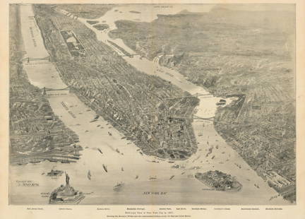
Sold2021New York Bay, 1897Bird’s-Eye View of New York City in 1897This small but intensely detailed map of the city of New York depicts a near snapshot of what could be seen from a rare objective-above. With Burroughs aSee Sold Price
Sold2022Uncommon Railroad map of New York City, Rand McNallyHighly detailed map of Manhattan and the surrounding boroughs with special attention to Elevated Railroads, Metropolitan Railroads, Steamboat Piers and Railroad Piers. Steamship lines located and nameSee Sold Price
Sold20191901 Map of New York City Transportation1901 Map of New York City showing passenger transportation systems. Map of New York City except Richmond borough showing passenger transportation systems July 1901. Supplement to Street Railway JournaSee Sold Price
Sold2015A Fine & Rare Map of New York.Bernard Ratzer "Plan of the City of New York". Signed lower right in the plate "T. Kitchin Sculpt" (Kitchin recorded the cartographer's name as Ratzen (sic) rather than Ratzer). The map backed, rolledSee Sold Price
Sold2015Town of Dover in Dutchess County, Atlas of New York byOriginal steel engraving by Augustus Mitchell, 1881. Map features city streets & railroads. Dimensions: 15” x 12”See Sold Price
Sold2022A RARE GRIBBROEK 1935 NATIVE AMERICAN POSTERRobert Gribbroek (1906-1971) historical pictorial map of New York State focused on its Native American tribes by Arthur Caswell Parker (1881-1955). Filled with portraits of prominent persons and sceneSee Sold Price
Sold20171865 Colton New York City Map1865 Colton New York City Map -- New York City Brooklyn, Jersey City, Hoboken, Etc. C. B. Colton 1865 New York 24 x 17 in. This nice map of New York City, including Manhattan, Brooklyn, Jersey City anSee Sold Price
Sold2022Antique NEW YORK CITY MAP - FramedAntique New York City Map. 28” x 16” New York City map, circa 1860, hand-colored, double matted and framed to 38 ½” x 26”.See Sold Price
Jun 09Estate Collection Auctioneer1986 Photo The Staten Island Anchorage viewed from Narrows Bridge Tower$250
May 11Freeman's | HindmanClaes Oldenburg (American, 1929-2022) - Proposed Colossal Monument for Staten Island, New York City$9,000
May 12Schilb Antiquarian Rare Books1881 Westchester County New York Yonkers Illustrated MAPS 2v SET Bolton History$26(3 bids)
May 16Potter & Potter Auctions[NEW YORK CITY – PICTORIAL MAPS]. Group of 3 pictorial maps...$200(1 bid)
Jun 02Schilb Antiquarian Rare Books1892 NEW YORK Darkness & Daylight NYC Detective Photography Criminal Travelogue$1
May 15University ArchivesDewitt Clinton & NYC Mayors Signed Checks Paying for City Expenses & NY Street Improvement Bond$100
May 19The Heritage Gallery at Sayville Antiques, IncWPA Style O/C NYC View Lower Manhattan From Staten Island$110(2 bids)


![[NEW YORK CITY – PICTORIAL MAPS]. Group of 3 pictorial maps... (1 of 3)](https://p1.liveauctioneers.com/928/325952/175495562_1_x.jpg?height=282&quality=70&version=1712935174)


