Sold20222-Pacific Highway & Pacific Coast Road Mapsrated 7 to 8, 9.5"x4.5", all have good color, all have very light wear.See Sold Price
Sold20231925-40 17 VIntage Pennsylvania Road MapsIncludes 1931 Commonwealth of PA Tourist Map of Highways; 1927 Commonwealth of PA State Highway Routes; 1925 Commonwealth of PA State Highway Routes; 1932 Commonwealth of PA Tourist Mpa of State HighwSee Sold Price
Sold20171715 MAPS William Dampier Voyages Pacific Islands1715 William Dampier Voyages Illustrated MAPS Pacific Islands Wars Guam Panama An incredible rare and desirable voyages book by William Dampier. This book covers some of the most important and famousSee Sold Price
Sold20211849 Wilkes Pacific US Expedition FIJI MAP Pacific1849 Wilkes Pacific US Expedition FIJI MAP Pacific Islands Australia Illustrated The ‘Wilkes Expedition’ was one of the most important exploration voyages ever taken on by the United States. It heSee Sold Price
Sold20222-Union Oil & 1-Pacific Coast Highway Road Mapsrated 6 to 8, 9"x4" or less in size, Pacific Coast map is in good condition, other two have light wear and soiling.See Sold Price
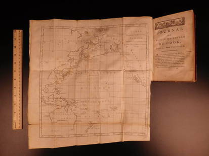
Sold20241783 Captain James Cook Third Pacific Voyage Illustrated MAP Australia Rickman1783 Captain James Cook Third Pacific Voyage Illustrated MAP Australia Rickman “Remember, the greater the opportunity, the fewer are those who see it.” – James Cook James Cook was an 18th-ceSee Sold Price
Sold20191783 Captain James Cook Third Pacific Voyage Illustrate1783 Captain James Cook Third Pacific Voyage Illustrated MAP Australia Rickman “Remember, the greater the opportunity, the fewer are those who see it.” – James Cook James Cook was an 18th-centurSee Sold Price
Sold20221927 Pennsylvania Highways Facts Motorists Should Know1927 Pennsylvania Highways Facts Motorists Should Know and New Hope and Ivyland Railroad, Harrisburg Steel Corporation, Union Pacific Railroad Stock Certificates Condition: Highway Facts book is in roSee Sold Price
Sold20221927 Union Oil Company Pacific Coast Road Maprated 6.75, 9"x4", cover has good color, has wear and a tear on the inside.See Sold Price
Sold20191844 Pacific Voyages D’Urville Australia MAP Magellan1844 Pacific Voyages D’Urville Australia MAP Magellan Cook Anson Vancouver MAPS Jules Dumont D’Urville was a 19th-century French explorer who is best known for his voyages in the South Pacific andSee Sold Price
Sold2022Rare 1st ed. map of Africa, Perthes 1845Full color map of Africa by ethnography. With an inset map of Australia, Polynesia, and the Pacific Islands. From the rare 1845/48 first edition/first state of “Physikalischer Atlas oder SammlunSee Sold Price
Sold20191830 D’Urville Pacific Voyages Illustrations Australia1830 D’Urville Pacific Voyages Illustrations Australia Tahiti MAPS Hawaii Jules Dumont D’Urville was a 19th-century French explorer who is best known for his voyages in the South Pacific and AntarSee Sold Price
Sold20191836 1ed Oceania Rienzi Polynesia Voyages MAPS1836 1ed Oceania Rienzi Polynesia Voyages MAPS Australia Captain Cook Pacific Louis de Rienzi was a 19th-century French voyager who is remembered for his 1836 masterwork ‘Oceania, or Fifth Part of tSee Sold Price
Sold20221836 1ed Oceania Rienzi Polynesia Voyages MAPS Australia Captain Cook Pacific1836 1ed Oceania Rienzi Polynesia Voyages MAPS Australia Captain Cook Pacific Louis de Rienzi was a 19th-century French voyager who is remembered for his 1836 masterwork Oceania, or Fifth Part of theSee Sold Price
Sold20211865 Hawaiian Islands Pacific Islands Kamehameha1865 Hawaiian Islands Pacific Islands Kamehameha Portraits EARLY HAWAII MAP Rufus Anderson’s “The Hawaiian Islands” is a 19th-century account of the Pacific islands covering the origin of the isSee Sold Price
Sold20191868 Bowles Rocky Mountains MAP Mormon Polygamy INDIANS1868 Bowles Rocky Mountains MAP Mormon Polygamy INDIANS California Pacific Samuel Bowles’s ‘Across the Continent’ is a Civil War-era book that covers the authors journey with Schuyler Colfax andSee Sold Price
Sold20211865 Bowles Travels MAP Mormon Polygamy INDIAN1865 Bowles Travels MAP Mormon Polygamy INDIAN California Pacific Rocky Mountain Samuel Bowles’s ‘Across the Continent’ is a Civil War-era book that covers the authors journey with Schuyler ColfSee Sold Price
Sold20201834 Pacific Voyages D’Urville Australia Magellan Cook1834 Pacific Voyages D’Urville Australia Magellan Cook Anson Vancouver MAPS Jules Dumont D’Urville was a 19th-century French explorer who is best known for his voyages in the South Pacific and AntSee Sold Price
Sold20201869 1ed Wild West INDIANS Mormon Gold Mine California1869 1ed Wild West INDIANS Mormon Gold Mine California Railroads MAP Bowles ‘Our New West’ is a record of travel on the Pacific Railroad from the Missouri River to the Pacific Ocean. Bowles givesSee Sold Price
Sold20231865 HUGE MAP 1ed Travel Mormon Polygamy LDS Indians Pacific Rocky Mountains1865 HUGE MAP 1ed Travel Mormon Polygamy LDS Indians Pacific Rocky Mountains Samuel Bowless Across the Continent is a Civil War-era book that covers the authors journey with Schuyler Colfax and WilliaSee Sold Price
Sold20211869 1ed Wild West INDIANS Mormon Gold Mine California1869 1ed Wild West INDIANS Mormon Gold Mine California Railroads MAP Bowles ‘Our New West’ is a record of travel on the Pacific Railroad from the Missouri River to the Pacific Ocean. Bowles givesSee Sold Price
Sold2018Rare 1921 auto road atlas. 11.7 x 15Reserve Reduced! This rare and unusual early auto road atlas was published during the time the National Highway System was being developed. It includes individual “auto-trails” maps for each stateSee Sold Price
Sold2017Rare French map of Alaska Panhandle 1896Heading: (North America - Pacific Northwest) Author: Title: Amérique du Nord - Côte Ouest. De Dixon Entrance à Cross Sound d'après les Cartes anglaises et américaines Place Published: [Paris, FrSee Sold Price
Sold2018Pacific Ocean.Reserve Reduced! Item: Pacific Ocean. Date: 1841 Cartographer: BOYNTON, GEORGE W., engr. Publisher: S.G. GOODRICH, Size (inches): 13X16.6 no regional divisions. Detailed map from a rare Peter Parley aSee Sold Price
3 days LeftJasper52Pacific Ocean sea chart. Ports lighthouses mail routes dockyards LARGE 1927 map$35
6 days LeftTrillium Antique Prints & Rare BooksCaptain Cook, Large Folio - Chart of the New Coast of America and New Coast of Asia$100
6 days LeftTrillium Antique Prints & Rare BooksCaptain Cook, Large Folio - A General Chart: Exhibiting the Discoveries made by Captain James Cook$200
Jul 11Dan Morphy AuctionsRARE INDEPENDENT GASOLINE & MOTOR OIL FRAMED GRAPHIC HIGHWAY MAP OF ILLINOIS.$125
Jun 28Rail & Road AuctionsGroup of Fourteen Railroad Stock Certificates - Illinois Central, Denver & Rio Grande Western,$30
Sterling Vault AuctioneersRARE 1927 18CT ZENITH LAND & WATER X BIRCH & GAYDON TRIPLE SIGNED POCKET WATCH, 18ct case, 46mm,£2(1 bid)
Jun 29JM Hobby Supply and Railroad Artifact AuctionsRare Missouri Pacific RR Blue/Green Lens Handlan Marker Lamp-1923$60(2 bids)
Jun 27Rail & Road Auctions52 Pieces of Union Pacific Railroad Ephemera - Pocket Calendars, Maps, Aluminum Coins, etc$30
Jun 27Rail & Road AuctionsSeven Chicago Burlington and Quincy / Burlington Travel Brochures and Booklets$20