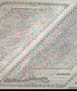
Sold2021RR map of Alabama from scarce Colton atlasStunning example of 1855 map of Alabama from a very scarce edition of Colton’s New General Atlas. Great original hand coloring and an excellent impression. Nicely centered. Clean on sound paper.See Sold Price
Sold2024Great vintage RR map of N. Carolina from scarce Colton atlasExcellent map of North Carolina just one year after being readmitted to the Union following the Civil War. The map was originally created in 1855 by J. H. Colton from a larger wall map, then updated aSee Sold Price
Sold2023Scarce 1850 RR and steamboat route map of Alabama“A New Map of Alabama with its Roads & Distances from Place to Place along the Stage and Steamboat Routes.” Fascinating map of this southern state from an exceedingly scarce atlas (dated 1850See Sold Price
Sold2022Scarce 1st ed. Colton RR map of North CarolinaLovely example of North Carolina map from the first edition of Colton’s Atlas of the World. One of the few mid-19th century maps to show North Carolina independently—it was more often mappSee Sold Price
Sold2024Scarce Georgia-Alabama Civil War-era RR map by Johnson & Browning, 1861Johnson’s Georgia and Alabama from the scarce 1861 edition of Johnson’s Family Atlas published shortly after the outbreak of the war in 1861 by Johnson & Browning. Shows network of railroaSee Sold Price
Sold2022Scarce early Cram RR map of Southern states“New Railroad and County Map of Alabama, Georgia, South Carolina and North Carolina” from the extremely scarce 1882 edition of Cram’s Unrivaled Family Atlas of the World. This was tSee Sold Price
Sold2022Elusive map of Maine from scarce Colton atlasUnusual map of Maine with hand coloring down to the township level. On this map railroad lines are depicted as tiny railroad tracks. Map is dated 1855; it’s taken from a scarce copy of ColtonSee Sold Price
Sold2021Map of Philadelphia from scarce Colton atlasHighly detailed map with identification of street names, important parks, rivers, and railroad lines. Lovely pastel red, green, tan, pink, and yellow hand coloring used to distinguish sections of theSee Sold Price
Sold2023Most impressive RR map of Georgia from scarce atlasGray’s New Map of Georgia by Frank A. Gray with a copyright date of 1877 by O. W. Gray. This very impressive and scarce map is from Gray’s very scarce 1884 National Atlas. It is aSee Sold Price
Sold2022Map of N. America from scarce Colton atlasA lovely and clean map from the very scarce Colton’s General Atlas of 1890, likely the last atlas the Colton family produced (Phillips lists 1888 as the last date). In over twenty years in the map bSee Sold Price
Sold2021Map of NY City from very scarce Colton atlasTitle: Map of NY City from very scarce Colton atlas Date: Map dated 1886 Description: Interesting map of NYC and vicinity, oriented with North at the top (most other double page maps of New York fromSee Sold Price
Sold2022Large RR map of Florida from scarce 1898 Cram's AtlasDramatic and huge map of Florida naming and showing all rail lines in the state. Every rail line is named, numbered and color-coded by a legend on the map. From the very scarce Cram’s BankersâSee Sold Price
Sold2023RR map of Arizona from scarce 1898 Cram’s Atlas.Large and dramatic double-page map of Arizona naming and showing all rail lines in the state. Every railroad line is named, numbered, and color-coded by a legend on the map. From the very scarce Cram�See Sold Price
Sold2023RR map of New Mexico from scarce 1898 Cram’s Atlas.Large and dramatic double-page map of New Mexico naming and showing all rail lines in the state. Every railroad line is named, numbered, and color-coded by a legend on the map. From the very scarce CrSee Sold Price
Sold2021Very scarce earliest McNally atlas RR mapRand McNally's first large format map of the United States, likely the earliest Rand McNally atlas map. Shows complete railroad network throughout the entire country. Untitled, but "Printed for HistorSee Sold Price
Sold20231894 hand-colored RR map of ColoradoLovely and informative, hand colored steel plate engraved railroad map of Colorado by William Bradley in 1894. From the Potter-Bradley atlas, a scarce atlas that appears to have had only one edition.See Sold Price
Sold2022Excellent and scarce map of Scotland, 1855From the first edition of J. H. Colton’s Atlas of the World. Lovely map of Scotland with full original hand coloring. Highly detailed with lakes (or lochs), towns, rivers, railroads, canals, roaSee Sold Price
Sold2018Colton: Antique Map of Alabama, 1859Title/Content of Map: Alabama by Colton Date Printed: 1859 Cartographer: H.J. Colton Material/Medium: Paper Size: 17 1/1" x 15" Hand colored,engraved. Published in New York in 'Colton's General Atlas.See Sold Price
Sold2019Scarce Colton 1855 map of Texas, Johnson/BrowningScarce large map of Texas with 1855 date, but with Johnson & Browning imprint. The Johnson & Browning imprint was found in only the 1859 Colton atlas and 1860 and 1861 Johnson Family atlases. This mapSee Sold Price
Sold2021Scarce RR map of Colorado - 1897Scarce and large 2-page map from the very scarce Cram’s 1897 Standard American Railway System Atlas of the World. Cram was unique in producing a special group of atlases for just a few years that hiSee Sold Price
Sold2023Scarce RR map of Iowa from Gray’s National AtlasGray’s New Map of Iowa by Frank A. Gray. Copyright 1877 by O. W. Gray and found in a copy of Gray’s scarce 1884 National Atlas. Shows great detail, with railroads towns, rivers and other iSee Sold Price
Sold2023Scarce RR map of Utah from Gray’s National AtlasGray’s New Map of Utah by Frank A. Gray. From a scarce 1884 edition of Gray’s National Atlas. Shows Indian reservations, deserts, railroads, topography. Clean with a 1.5” tear at topSee Sold Price
Sold2021Scarce RR map of Wisconsin, 1875Uncommon and large map of Wisconsin found only in the Wisconsin edition of the very scarce Jones and Hamilton Atlas of the World Illustrated, published 1875 by H. H. Hardesty. Huge top and bottom margSee Sold Price
Sold20231859 Map of Alabama by ColtonTitle: 1859 Map of Alabama by Colton Date/Period: 1859 Materials: Steel engravedSize: 17 1/2 x 14 1/2” Alabama. From before the civil war. By J. H. Colton & G. W. Colton. From "General Atlas". PSee Sold Price
4 days LeftJasper52GREATER ANTILLES. Cuba Hispaniola Jamaica Bahamas. Haiti Dominican Rep. 1947 map$10
Featured4 days LeftJasper52The Bahamas, Cuba & Bermuda "or Summer Islands". THOMSON 1817 old antique map$180