Sold2022RR map of Colorado from 1888 Cram atlasAuthentic vintage map of Colorado with counties delineated in color by hachures. Shows complete network of railroads during this period. Gives an indication just how fast the state was growing…iSee Sold Price
Sold2021Scarce RR map of Colorado - 1897Scarce and large 2-page map from the very scarce Cram’s 1897 Standard American Railway System Atlas of the World. Cram was unique in producing a special group of atlases for just a few years that hiSee Sold Price
Sold2022Large RR map of Florida from scarce 1898 Cram's AtlasDramatic and huge map of Florida naming and showing all rail lines in the state. Every rail line is named, numbered and color-coded by a legend on the map. From the very scarce Cram’s BankersâSee Sold Price
Sold2023RR map of Arizona from scarce 1898 Cram’s Atlas.Large and dramatic double-page map of Arizona naming and showing all rail lines in the state. Every railroad line is named, numbered, and color-coded by a legend on the map. From the very scarce Cram�See Sold Price
Sold2023RR map of New Mexico from scarce 1898 Cram’s Atlas.Large and dramatic double-page map of New Mexico naming and showing all rail lines in the state. Every railroad line is named, numbered, and color-coded by a legend on the map. From the very scarce CrSee Sold Price
Sold20231894 hand-colored RR map of ColoradoLovely and informative, hand colored steel plate engraved railroad map of Colorado by William Bradley in 1894. From the Potter-Bradley atlas, a scarce atlas that appears to have had only one edition.See Sold Price
Sold2022Scarce early Cram RR map of Southern states“New Railroad and County Map of Alabama, Georgia, South Carolina and North Carolina” from the extremely scarce 1882 edition of Cram’s Unrivaled Family Atlas of the World. This was tSee Sold Price
Sold2022Scarce 1882 hand-colored RR map of Michigan/WisconsinFrom the very scarce 1882 edition of Cram’s Unrivaled Family Atlas of the World. This was the last atlas that featured hand colored maps. Today it is extremely scarce, as are the maps containedSee Sold Price
Sold2023Scarce early Cram RR map of the Deep SouthFrom a very scarce Cram atlas comes this map of the Deep South showing the areas railway system in place in 1882. ”New Railroad and County Map of Arkansas, Louisiana & Mississippi.” The 18See Sold Price
Sold2023Scarce early Cram RR map of Missouri“New Railroad and County Map of Missouri” from an exceedingly scarce 1882 edition of Cram’s Unrivaled Family Atlas of the World.” Collections of vintage maps of Missouri will nSee Sold Price
Sold2022Scarce and impressive early Cram RR map of DakotaVery scarce double-page map of the Dakota Territory from the scarce 1882 edition of Cram’s Unrivaled Family Atlas of the World. The 1882 atlas was the last Cram atlas to feature hand coloring oSee Sold Price
Sold2022Scarce early Cram RR map of North CarolinaDesirable and scarce railroad map of North Carolina from a very scarce and early Cram atlas. The 1882 edition of Cram’s Unrivaled Family Atlas of the World was the last Cram atlas to use hand cSee Sold Price
Sold2022Scarce early Cram RR map of New YorkExceedingly scarce New York state map from the last Cram atlas to feature hand colored maps. “New Railroad and County Map of New York” from the very scarce 1882 Cram’s Unrivaled FamSee Sold Price
Sold20201888 Map of DallasAuthor: Cram Title: 1888 Map of Dallas Medium: Ink on Paper Dimensions: 11.5"X14.5" Map of Dallas dated 1888. Engraved and published by George Cram in Chicago. Part of Cram's Universal Atlas. DetailedSee Sold Price
Sold20211895 Colorado MapAuthor: Cram Title: 1895 Colorado Map Medium: Ink on Paper Dimensions: 22.5"X14.5" Description: Map of Colorado dated 1895. Printed by George Cram for Walker's International Atlas. Published in ChicagSee Sold Price
Sold20231888 Railroad map of Montana locates battlefieldsDouble-page, vertical format map of Montana from an 1888 edition of George F. Cram's Unrivaled Family Atlas. An authentic, antique map that places battlefields, Indian reservations, t towns, rivers, lSee Sold Price
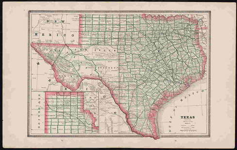
Sold2022Clean 1883 RR map of Texas, Geo. F. CramInteresting cerographic map of Texas from Cram’s Unrivaled Family Atlas of the World. Predates subdivision of Tom Green, Pecos, Crockett and Presidio Counties. Shows rail system throughout statSee Sold Price
Sold2021Scarce 1882 RR map of New JerseyScarce map of New Jersey from the first mass-produced world atlas by George F. Cram. He published at least two versions of his 1883 Universal Family Atlas, an early edition and a later edition. The eaSee Sold Price
Sold2023Authentic 1888 Railroad map of Colorado from Geo. F. CramPainstaking delineation of topography in this really nice map of Colorado. Shows and names each line of the rail system in place at this time. Locates towns, rivers, springs, forts, military reservatiSee Sold Price
Sold2021Scarce and huge RR map of California – 1898Toward the end of the 19th century, the better atlas makers had pushed the size and quality of their maps to the limit. George F. Cram was one of these publishers, but he also put out a special groupSee Sold Price
Sold2020Colorado 1888Title/Content of Map: Colorado 1888 Date Printed: 1888 Material/Medium: paper Size: approx. 21x 14 inches Additional Info: Jonh C. Lonngren & Son Standard Atlas Reserve: $30.00 Shipping: Domestic: FlaSee Sold Price
Sold20211888 Map of CaliforniaAuthor: Cram Title: 1888 Map of California Medium: Ink on Paper Dimensions: 13.5"X21.5" Map of California dated 1888. Printed and published by George Cram in Chicago. Part of his World Atlas. Key loweSee Sold Price
Sold20211883 Map of ColoradoAuthor: Cram Title: 1883 Map of Colorado Medium: Ink on Paper Dimensions: 13.5"X11" Map of the Colorado dated 1883. Printed and published by George Cram in Chicago. Part of his World Atlas. Key lowerSee Sold Price
Sold20211888 Map of CaliforniaTitle: 1888 Map of California Medium: Ink on Paper Dimensions: 14.5"X22" Description: Map of California dated 1888. Printed and published by George Cram in Chicago. Part of his World Atlas. Key lowerSee Sold Price
Featured3 days LeftJasper52PACIFIC OCEAN currents British French German US Spanish colonies. LETTS 1889 map$15
3 days LeftJasper52South Pacific Ocean. Polynesia "Dangerous Archipelago" Galapagos LIZARS 1842 map$40
3 days LeftJasper52Polynesia. Fiji, Hawaiian & Samoan islands. Vanua/Viti-Levu. THE TIMES 1895 map$40
Featured2 days LeftJasper521795 Lewis Map of Maryland -- The State of Maryland, from the best Authorities$360
Featured3 days LeftJasper52NW Coast of America & NE Coast of Asia… ROBERTS / DELAROCHETTE. Pacific 1794 map$700
3 days LeftJasper52Oceania or Islands in the Pacific Ocean. Polynesia Australasia SWANSTON 1860 map$55
3 days LeftJasper52Océanique. Archipel des Nouvelle Hébrides #39. Vanuatu. VANDERMAELEN 1827 map$85
6 days LeftTrillium Antique Prints & Rare BooksMitchell's A New Universal Atlas.. - Volume with 73 Maps$1,000(1 bid)
2 days LeftJasper521865 Colton Map of US Southwest -- Colton's Map of California, Nevada, Utah, Colorado, Arizona & New$160