Sold2021Scarce Civil War map - Union ops in Ky and Tenn., 1875Elusive map showing the armies of the Cumberland and Ohio’s operations in Kentucky and Tennessee in the Civil War. “No. 1 Map Exhibiting the Operations of the Armies of the Cumberland andSee Sold Price
Sold2021Scarce Civil War map showing entire ops of Army ofTitle: Scarce Civil War map showing entire ops of Army of Cumberland Description: Highly detailed, hard-to-find vintage map showing the entire scope of operations of the Army of the Cumberland duringSee Sold Price
Sold2021Scarce Civil War map showing Jeff Davis’ line ofTitle: Scarce Civil War map showing Jeff Davis’ line of flight, 1875 Description: "Elusive map showing the Union Army’s operations after Atlanta. “No. 16 Map Exhibiting the Operations ConductedSee Sold Price
Sold2022Scarce Civil War era map of Florida with great detail,Great map of Florida showing the entire state (includes small inset of Florida Keys). Shows state shortly after the outbreak of the Civil War. Notes proposed course of a canal route from Tampa to theSee Sold Price
Sold2015Fisk & Russell Scarce Civil War Pocket MapThis circa 1862 hand colored folded pocket map was printed by Fisk & Russell, N.Y., no date or title but shows most of the U.S. and southern Canada with small inset map of ‘Eastern Part of MassaSee Sold Price
Sold2019Alexandria, VA map by James TuthillScarce untitled Civil War era map of the area between Washington, D.C. and Mount Vernon by James Tuthill, lithographed by Herline and Hensel, Philadelphia, PA, published in Camden, NJ, circa 1861. IntSee Sold Price
Sold20231899 1ed Life of Stonewall Jackson Campaigns Civil War Battles Confederate Maps1899 1ed Life of Stonewall Jackson Campaigns Civil War Battles Confederate Maps A scarce, childrens educational work by Mary L. Williamson on the life and military career of “Stonewall” JaSee Sold Price
Sold2022Civil War Military map - scarce territorial bordersThe Johnson and Ward atlas company produced two memorable, double-page Civil War maps of the United States. This is the more desirable issue, showing the state and territory borders instead of the MilSee Sold Price
Sold20231899 Confederate 1ed Life of Stonewall Jackson Campaigns Civil War Battles Maps1899 Confederate 1ed Life of Stonewall Jackson Campaigns Civil War Battles Maps A scarce, childrens educational work by Mary L. Williamson on the life and military career of “Stonewall” JaSee Sold Price
Sold20241899 Confederate 1ed Life of Stonewall Jackson Campaigns Civil War Battles Maps1899 Confederate 1ed Life of Stonewall Jackson Campaigns Civil War Battles Maps A scarce, childrens educational work by Mary L. Williamson on the life and military career of “Stonewall” JacksoSee Sold Price
Sold20221899 Confederate 1ed Life of Stonewall Jackson Campaigns Civil War Battles Maps1899 Confederate 1ed Life of Stonewall Jackson Campaigns Civil War Battles Maps A scarce, childrens educational work by Mary L. Williamson on the life and military career of “Stonewall” JaSee Sold Price
Sold2024Official Civil War Geographical Boundary map, Julius Bien 1891Scarce definitive map of the geographical boundaries between the Union and Confederate armies. Opens a window into the state of the U. S. during the height of the Civil War. “Map of the United SSee Sold Price
Sold2021Vic. of Richmond Civil War map, Johnson 1862A scarce and important map produced during the Civil War. The map shows the Union advance during the Peninsular Campaign including great detail ranging from nautical depth soundings to individual builSee Sold Price
Sold2017Johnson: Antique Civil War Map of Richmond, 1862Scarce and important 1862 A. J. Johnson map of the vicinity of Richmond, Virginia, during the American Civil War. Full title: “Johnson’s Map of the Vicinity of Richmond, and Peninsular CaSee Sold Price
Sold2017Scarce Confederate School Geography Richmond 1864Heading: (Confederate Imprint) Author: Stewart, K.J. Title: A Geography for Beginners Place Published: Richmond, VA Publisher:J.W. Randolph Date Published: 1864 Description:See Sold Price
Sold2017Johnson: Antique 1st Edition Civil War Military Map1st edition Johnson’s Civil War Military Map, Johnson & Browning. Scarce 1861 map by A. J. Johnson showing the military deportment of the United States in 1860, just before war broke out in the statSee Sold Price
Sold2022Rare Seat of War 1862 Civil War pocket mapVery desirable and scarce large map of the Civil War issued during the early part of the war. Includes Virginia, Maryland and the Chesapeake Bay along with parts of other states. Depicts the entire EaSee Sold Price
Sold2024Great vintage RR map of N. Carolina from scarce Colton atlasExcellent map of North Carolina just one year after being readmitted to the Union following the Civil War. The map was originally created in 1855 by J. H. Colton from a larger wall map, then updated aSee Sold Price
Sold2022Louisiana & Alabama with Mississippi, 1864 scarce publication by SchonbergTitle: Louisiana & Alabama with Mississippi, 1864 scarce publication by Schonberg Date/Period: 1864 Materials: Hand colored steel plate engraved. Size: 14 x 12 inches 1864 uncommon civil war era map bSee Sold Price
Sold2022Title page of Schonberg’s 1864 atlas, 1864 scarce publication by SchonbergTitle: Title page of Schonberg’s 1864 atlas, 1864 scarce publication by Schonberg Date/Period: 1864 Materials: Hand colored steel engraved Size: 14 x 12'' 1864 uncommon civil war era map by SchoSee Sold Price
Sold2022llinois & Ohio with Indiana, 1864 scarce publication by SchonbergTitle: llinois & Ohio with Indiana, 1864 scarce publication by Schonberg Date/Period: 1864 Materials: Hand colored steel plate engraved. Size: 14 x 12 inches 1864 uncommon civil war era map by SchonbeSee Sold Price
Sold2022Germany & Austrian Empire 1864. Scarce publication by SchonbergTitle: Germany & Austrian Empire 1864. Scarce publication by Schonberg Date/Period: 1864 Materials: Hand colored steel engraved Size: 14 x 12'' 1864 uncommon civil war era map by Schonberg, New York.See Sold Price
Sold2022Prussia with Saxony & Switzerland 1864. Scarce publication by SchonbergTitle: Prussia with Saxony & Switzerland 1864. Scarce publication by Schonberg Date/Period: 1864 Materials: Hand colored steel engraved Size: 14 x 12 inches 1864 uncommon civil war era map by SchonberSee Sold Price
Sold2023Scarce & important 1837 map of St. Louis Harbor by Robt. E. Lee & Lt. MeigsScarce and fine map of the area around St. Louis, prepared under the supervision of Robert E. Lee when he was a lieutenant. Engraved map with folds as issued and later hand coloring. A detailed map ofSee Sold Price
Jul 07Case Antiques, Inc. Auctions & Appraisals3 Civil War Era Photos, incl. Rose O'Neal Greenhow, poss. Jeff Davis$150
Featured2 days LeftUniversity ArchivesCapture of Jefferson Davis: “Mr. Davis tried to escape…with a ladies waterproof$1,600
3 days LeftSwann Auction Galleries(CIVIL WAR--CONFEDERATE.) A late issue of the Daily Constitutionalist, one of the last Confederate$450
Jul 14Schilb Antiquarian Rare Books1928 Life of Abraham Lincoln 1ed SLAVERY Civil War Albert Beveridge 2v SET$1(1 bid)
Jul 04Weatherham Estate TreasuresAbraham Lincoln Bronze Bust Sculpture On Marble Base - Signed Original - 10lbs$400
2 days LeftUniversity ArchivesThe 24th Louisiana Consolidated Crescent Disbands After Shiloh…with Two Other Fine Documents$160(2 bids)
Jul 14Schilb Antiquarian Rare Books1885 Civil War 1ed Memoirs of Union General Ulysses S. Grant Illustrated MAPS 2v$135(7 bids)
3 days LeftSwann Auction Galleries(CIVIL WAR--VIRGINIA.) Robert B. Hathaway. Letter with detailed map of the possible river crossings$600
Freeman's | Hindman[CIVIL WAR - CONFEDERATE]. Southern Historical Society Papers. Richmond, VA. 1876-1910.$250(1 bid)
Featured2 days LeftUniversity ArchivesAbraham Lincoln PSA GEM MT 10 CDV, Signed 3 Weeks Before His Death.$32,500(2 bids)
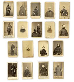
2 days LeftUniversity Archives18 pc. CDV Archive of Civil War Generals Incl. Many Brady & E. Anthony Examples$260(1 bid)
Jul 06Case Antiques, Inc. Auctions & AppraisalsCivil War Veteran GAR Uniform, PVT Stephen F. Oliver$200(1 bid)
2 days LeftUniversity ArchivesIconic U.S. Grant Battlefield Albumen by Mathew Brady at City Point During Siege of Petersburg$240
Jul 07Worthington Galleries1st Edition Frank Leslie's The Soldier in Our Civil War: A Pictorial History of the Conflict$20(1 bid)
4 days LeftSouth Florida Auction & Estate Sale Services IncCivil War Abraham Lincoln Tin Type Photograph$8(2 bids)


![[CIVIL WAR - CONFEDERATE]. Southern Historical Society Papers. Richmond, VA. 1876-1910. (1 of 1)](https://p1.liveauctioneers.com/197/333931/180433424_1_x.jpg?height=282&quality=70&version=1719251417)