Sold2020Six Nations New York Map and North Eastern States MapItems as shown. Framed 20x15 & 18x14See Sold Price
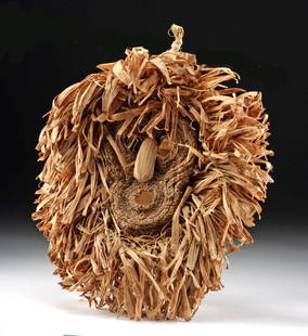
Sold2023Iroquois Corn Husk Mask Gajesa / Bushy HeadNative American / First Nations, Northeastern United States, New York, or Canada, Ontario, Six Nations, Iroquois, ca. early to mid-20th century CE. A corn husk mask known as Gajesa or Bushy Head, theSee Sold Price
Sold2023Iroquois Corn Husk Mask - Gajesa / Bushy Head (False Face Society)Native American / First Nations, Northeastern United States, New York, or Canada, Ontario, Six Nations, Iroquois, ca. late 20th century CE. A corn husk mask known as Gajesa or Bushy Head, the braidedSee Sold Price
Sold2023Six maps of various regions of the United States, from municipal to multiple states in scale,Six maps of various regions of the United States, from municipal to multiple states in scale, including: "A Chorographical Map of the Province of New York in North America", Pease, 1849, 40" h. x 32"See Sold Price
Sold2018Colton: Antique Map of North Eastern Africa, 1859Title/Content of Map: North eastern Africa by Colton Date Printed: 1859 Cartographer: H.J. Colton Material/Medium: Paper Size: 17 1/2" X 15" Hand colored,engraved. Published in New York in 'Colton's GSee Sold Price
Sold2018Bellin: Antique Map of Northeastern Colonial AmericaTitle/Content of Map: Northeastern Colonial America by Bellin Date Printed: 1740-70's Cartographer: J.N. Bellin& J.F. La Harpe Size: 13" x 10" Material/Medium: Paper Provenance: New York Copperplate eSee Sold Price
Sold20221855 Colton Map of Northeastern Africa -- Africa North Eastern SheetTitle: 1855 Colton Map of Northeastern Africa -- Africa North Eastern Sheet Cartographer: J Colton Year / Place: 1855, New York Map Dimension (in.): 14.6 X 12 in. This is a very nice map of northeastSee Sold Price
Sold20231950s Iroquois False Face Society MaskNative American / First Nations, Northeastern United States, New York / Canada, Ontario, Iroquois, ca. 1950s to 1960s CE. A hand-carved wood "False Face Society" mask with long horsehair. The featuresSee Sold Price
Sold2019USA 1911 Lot of 5 Maps from The Encyclopedia BritannicaNorth America, plus 4 State Maps - Wisconsin, Ohio, New Hampshire/Vermont, and New York. Lithograph Maps Published 1911, New York for "The Encyclopaedia Britannica" 11th Edition by Various ContributorSee Sold Price
Sold20213 antique maps, New York, North East United States3 maps, New York, North East, includes "Carte réduite des côtes orientales de l'Amérique septentrionale : contenant celles des provinces de New-York et de la Nouvelle Angleterre, celles de l'AcadieSee Sold Price
Sold2018Thomson: Antique Map Northeastern United States, 1817Northern Provinces of the United States The beautifully detailed and colored northern United States map from Thomson's New General Atlas, with a lovely inset view of "the Great Falls of Niagara.'" CarSee Sold Price
Sold2023Two early maps in America and North America.Two early hand colored maps of New York State & North America including: The first, New Caldonia when it was still a colony of Scotland, dated 1699 - published by M. Moll - very good condition; and thSee Sold Price
Sold2021Antique Map of North Eastern United StatesMap of North Eastern of the United States, Asher and Adams, signature to lower right reads Asher & Adams’ New Hampshire, Vermont, Massachusetts, Rhode Island and Connecticut, subject a map of EasterSee Sold Price
Sold2020Early Map of America, Eastern United States, M. SeutterTitled "Novi Belgii in America Septentrionali" with very elaborate cartouche and with vignette view of New Amsterdam (New York). Exquisite color, well preserved, laid down. Size: 19 7/8" x 22 3/4" (siSee Sold Price
Sold20222 maps, colonial New York & North America, New York2 maps, colonial New York & North America, New York City, North River, Hudson Valley, "for D1, Valentine's Manual, for 1860, 13' by 10" & map of North America, United States, with various illustrationSee Sold Price
Sold2022Emanuel Bowen Map USA Eastern Seaboard 1740s New YorkEmanuel Bowen, map of United States Eastern Seaboard, Emanuel Bowen (British, 1694-1767), "A New and Accurate Map of New Jersey, Pennsylvania, New York, and New England", c. 1744, from Maryland to NovSee Sold Price
Sold2020USA 1903 Lot of 8 State Maps of New York & East CoastIncl Maine, Vermont/New Hampshire, Mass., Connecticut/Rhode Island, New York South, New York North, New York West and New Jersey. Lithograph Maps Published 1903 by Adam & Charles Black, Edinburgh & LoSee Sold Price
Sold2021Lot/3 Antique Maps of United States, Albany New YorkLot of three antique maps. A large hanging map of North America and Central America. United States Ornamental map with Presidents around the border. Hanging map of Albany New York by Jay Gould. All wiSee Sold Price
Sold2022PURCELL, JOSEPH A Map of the States of Virginia North Carolina South Carolina and GeorgiaPURCELL, JOSEPH A Map of the States of Virginia North Carolina South Carolina and Georgia Comprehending the Spanish Provinces of East and West Florida... New Haven: Amos Doolittle, 1788. Engraved mapSee Sold Price
Sold2016General Map of the North Pacific States and TerritoriesJohn Mullan (1830-1909). New York: Wm. M. Franklin, 1865. Engraved map with original hand color. 25 x 39 inches visible, 29 1/2 x 44 inches framed.See Sold Price
Sold20231748 Map of North America, Comprehending 'The Course to Ohio'America, 18th century. An early map of the eastern coast, detailing New England, New York, and more. No maker marks present. Overall good condition; complete on laid paper.See Sold Price
Sold20181839 Mitchell Map of New York to North Carolina -- No.Title/Content of Map: 1839 Mitchell Map of New York to North Carolina -- No. 11 Map of the Middle States and Part of Southern… Date: 1839 Philadelphia Cartographer: S Mitchell Size: 16.8 x 10.4 in.See Sold Price
Sold20231858 Mitchell Map of New York to North Carolina -- No. 11 Map of the Middle States and Part of theTitle: 1858 Mitchell Map of New York to North Carolina -- No. 11 Map of the Middle States and Part of the Southern… Cartographer: S Mitchell Year / Place: 1858, Philadelphia Map Dimension (in.):See Sold Price
Jun 08Early American History Auctions1853 Map of Portion of British North America and Gulf of St. Lawrence, by Henry Perley$260
3 days LeftSanta Cruz Auction CompanyPersian Engraved Tinned Copper Plaque with an Angel 19th Century$50
6 days LeftJasper521874 Holmes Plan of New York's Upper East Side -- Map of the Common Lands from 76th to 93rd Street$750
7 days LeftJasper52Partie méridionale Du Bresil… River Plate basin Brazil Uruguay. BONNE 1780 map$25
7 hrs LeftSloans & KenyonTOTAL ECLIPSE OF THE SUN : SEE NIGHT-TIME WHEN ITS DAY IN NEW ENGLAND WHILE YOU PLAY JOHN HELD JR$1,000
Jun 12Dan Morphy AuctionsPHELPS’S TRAVELERS GUIDE THROUGH THE UNITED STATES; CONTAINING UPWARDS OF SEVEN HUNDRED$1,000
1 day LeftRapid Estate Liquidators and Auction Gallery6 1980s 1990s National Geographic Magazines A$35
1 day LeftRapid Estate Liquidators and Auction Gallery4 Ecology Of Eastern Forest & Tree Finder Paperbacks$25
3 days LeftMynt Auctions1992 Eastern Conf Semi Finals Game 7 Bulls Clinch Over Knicks MJ 42 Pts PSA 3$10(1 bid)


![[STEREOS] NEW YORK CITY. LOT OF 9 SOLD TOGETHER (1 of 4)](https://p1.liveauctioneers.com/8124/329803/177770621_1_x.jpg?height=282&quality=70&version=1715634941)

