Sold2019Thomas Conder (1747-1831), "A New Map of North AmericaThomas Conder (1747-1831), "A New Map of North America Agreeable to the Most Approved Maps and Charts," H. - 14 in., W. - 18 in.See Sold Price
Sold2022Canada.- Jefferys (Thomas) An Exact Chart of the RiverCanada.- Jefferys (Thomas) An Exact Chart of the River St. Laurence, from Fort Frontenac to the Island of Anticosti Shewing the Soundings, Rocks, Shoals &c..., large-scale navigational chart of the StSee Sold Price
Sold2018Canada.- Jefferys (Thomas) An Exact Chart of the RiverCanada.- Jefferys (Thomas) An Exact Chart of the River St. Laurence, from Fort Frontenac to the Island of Anticosti Shewing the Soundings, Rocks, Shoals &c..., large-scale navigational chart of the StSee Sold Price
Sold2019Virgin Islands Carribbean Sea ChartThe Virgin Islands from English and Danish Surveys by Thomas Jefferys. English map. Sight 18 1/2" x 24 1/2".See Sold Price
Sold2020Massachusetts & Rhode Island. With insert of Boston andTitle: Massachusetts & Rhode Island. With insert of Boston and population chart. 1850 by Thomas. Date/Period: c1850 Materials: Hand colored, steel engraved. Size: 16 1/2 x 13 1/2 inches. c1850 by ThomSee Sold Price
Sold2022FULLER, CAPTAIN WILLIAM; JEFFERYS, THOMAS; and DE BRAHM, WILLIAM GERARD Plan of Amelia Island inFULLER, CAPTAIN WILLIAM; JEFFERYS, THOMAS; and DE BRAHM, WILLIAM GERARD Plan of Amelia Island in East Florida [and] A Chart of the Entrance into St. Mary's River...[and] A Chart of the Mouth of NassauSee Sold Price
Sold2020Early Hand Colored Map North America by T ConderAntique framed hand colored early map of North America. Top left image of Native man and foliage, reads "North America agreeable to the most approved Maps and Charts, by Thomas Condor" Frame: 14 3/4 iSee Sold Price
Sold201718th Century Map of the Carolinas by Thomas Conder1788, London. The map features the Carolinas and part of Georgia including Savannah and Augusta. The piece is in good overall condition with some scattered wrinkles and fold lines consistent with ageSee Sold Price
Sold20231730 Thomas Chart of the Sun -- Systema SolisTitle: 1730 Thomas Chart of the Sun -- Systema Solis Cartographer: C Thomas Year / Place: 1730, Frankfurt, Leipzig Map Dimension (in.): 4.7 X 5.1 in. This is a remarkable depiction of sun surface andSee Sold Price
Sold20231782 COPPERPLATE ENGRAVED MAP OF EUROPEOriginal antique copperplate engraved map of “Europe” engraved for Baldwins New Complete and Universal System of Geography. Published by Thomas Conder circa 1782.Professionally framed andSee Sold Price
Sold2018Poland Divided, Wilkinson Map 1794, London, 1st EditionPoland with its Dismembered Provinces, Drawn from the Best Authorities, 1794. Engraved by Thomas Conder for the 1794 first edition of Robert Wilkinson General Atlas. DIMENSIONS: 13.25 x 10.75 inches (See Sold Price
Sold20191572 Munster map of Islands, Sea Monsters, ShipsNo Reserve! Nice map of various islands from Munster’s “Cosmographia,” one of the most important early atlases. This woodcut is typical in that Munster used the same woodcut to illustrate the WeSee Sold Price
Sold2021Wright, Paul 1782 Holy Land Map. Jerusalem"A Correct Plan of the Antient City of Jerusalem" by Thomas Conder. Folio Copper Plate Published 1782, London for "The Complete British Family Bible…" by Paul Wright. Paper Size: 14.5 x 9.5 inch (37See Sold Price
Sold2021Wright, Paul 1782 Holy Land Map. Canaan, Israelites"A Map of the Land of Canaan" and "The Journeyings of the Israelites thro the Wilderness to Canaan" by Thomas Conder. Folio Copper Plate Published 1782, London for "The Complete British Family Bible��See Sold Price
Sold2021Wright, Paul 1782 Holy Land Map. Apostles Travels etcTwo maps on one sheet by Thomas Conder "A Map of the Countries where the Apostles Travell'd…" and "A Map of the more remote Places mentioned in the New Testament" Folio Copper Plate Published 1782,See Sold Price
Sold2023Original 1926 Tony Sarg Nantucket Map Chromolithograph PrintOriginal 1926 Tony Sarg Nantucket Map Chromolithograph Print, whimsical map showing various island sights, history and personalities, in original Tony Sarg red painted frame.See Sold Price
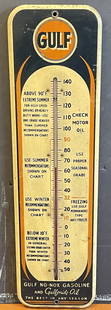
Sold2024Gulf No Nox Gasoline & Gulfpride Oil Tin Service Station ThermometerAn excellent displaying example of this seldom seen Tin Service Station Thermometer from Gulf advertising for Gulf Gasoline as well as Gulfpride Motor Oils showing various chart recommendations througSee Sold Price
Sold2023OCEANIA & ISLAND COUNTRIES SILVER COINSOCEANIA & ISLAND COUNTRIES SILVER COINS Lot of silver coins from Oceania and various island countries, including: Bahamas 1966 50 Cents Bahrain 1968 500 Fils Bermuda 1959 1 Crown BritishSee Sold Price
Sold2015BRITISH CONDER THOMAS PAINE & SPENCE HALFPENNY TOKENS1790s era anti-Thomas Paine token with hanging man and 'End of Pain' on obverse, and 'May the knave of Jacobin Clubs never get a trick' to reverse. 29mm diameter. A British dedication to Thomas Paine,See Sold Price
Sold2018Bellin: St. Thomas, Virgin IslandsMap: Carte de l'Isle de St. Thomas l'Une des Vierges Cartographer: Jacques Nicolas Bellin Place & Date: Paris / 1764 Size: 14" X 8 1/2" Condition: wash color; overall age toning within lighter margin;See Sold Price
Sold2017Oldendorp: View of St. Thomas (Virgin Islands), 1768Map: Aussicht von Neu-Herrnhut auf St. Thomas von der Ostseite Cartographer: Oldendorp / Nussbiegel and Sturm Place & Date: Nurnberg / 1768 Size: 10 3/8" x7" A fascinating engraved view of one of theSee Sold Price
Sold2021Lot of Various Thomas the Tank Engine FiguresLot of Various Thomas the Tank Engine FiguresSee Sold Price
Sold20191929 St. Thomas + Prince Islands 50 Centavos.1929 St. Thomas + Prince Islands 50 Centavos.See Sold Price
Sold2022Conder, Thomas 1794 Large Map of France"A New & Accurate Map of France divided into Departments, Districts &c" Copper Engraved Map Published 1794, London for "A New Royal Authentic and Complete System of Universal Geography" by George BaldSee Sold Price
4 days LeftMynt Auctions1930 St Thomas Virgin Islands First Flight Airmail Cover To Brazil 92 Flown!$370
6 days LeftAkiba Galleries(2 Pc) Allain Manesson Mallet Description De L'Univers 2 Vol. German Translation$200(1 bid)
7 days LeftEmanon Auctions and Estate SalesLot of various toys(Winnie the Pooh, Thomas the Train, and more)$5
18 hrs LeftJasper52Grand Bahama & Great Abaco Islands. Bahamas. ADMIRALTY sea chart 1886 (1968) map$140
18 hrs LeftJasper52West India Islands & Caribbean Sea Sheet 2 ADMIRALTY sea chart 1913 (1949) map$120
Featured18 hrs LeftJasper52Anguilla St. Martin/Maarten Barts. Caribbean. US Navy sea chart 1899 (1917) map$280
18 hrs LeftJasper52Bahamas harbours Pelican Abaco Berry I Jumentos ADMIRALTY chart 1899 (1920) map$140
2 days LeftMynt Auctions1896 Denmark DWI Danish West Indies Cover St Thomas to NY USA Rudolph Neubawe$450
May 15University ArchivesDealer's Lot Political Autographs, 7 Signers Incl. Ford, Humphrey, Dewey, Hamlin, Etc., 4 PSA/DNA$140(1 bid)
May 23Potter & Potter Auctions[HARPER’S WEEKLY]. Group of 15 Engraved Prints Appearing in...$100


![FULLER, CAPTAIN WILLIAM; JEFFERYS, THOMAS; and DE BRAHM, WILLIAM GERARD Plan of Amelia Island in: FULLER, CAPTAIN WILLIAM; JEFFERYS, THOMAS; and DE BRAHM, WILLIAM GERARD Plan of Amelia Island in East Florida [and] A Chart of the Entrance into St. Mary's River...[and] A Chart of the Mouth of Nassau](https://p1.liveauctioneers.com/292/250642/130213561_1_x.jpg?height=310&quality=70&version=1654271664)


![[HARPER’S WEEKLY]. Group of 15 Engraved Prints Appearing in... (1 of 4)](https://p1.liveauctioneers.com/928/328184/176813659_1_x.jpg?height=282&quality=70&version=1714496988)