Sold2018Two Prints - A Map & A PlantTwo prints: a map and a plant. [Overall dimensions: 20 x 23 1/2 inches; 22 1/2 x 16 inches].See Sold Price
Sold2021TWO PRINTS - Map of Ireland and The DeclarationTWO PRINTS - Map of Ireland and The Declaration of Independence. Older Irish map. Both approx. 17" x 15".See Sold Price
Sold2024[MAPS] WYETH. EASTERN/WESTERN HEMISPHERES. 1928WYETH, N.C. Two map prints. EASTERN HEMISPHERE; WESTERN HEMISPHERE. National Geographic, 1928. Fourth and fifth of a series of five murals by N.C. Wyeth that appeared as frontispieces in several NatioSee Sold Price
Sold2016N. C. Wyeth, Map of Discovery, Eastern & WesternTwo framed vintage prints / maps after N.C. Wyeth. "Map of Discovery, Eastern & Western Hemisphere". Signed and dated in the prints 1927. The images measure 15.5" x 17.75". Framed and matted under glaSee Sold Price
Sold2018Two Vintage Map PrintsIdentically framed, both frames damaged. Total: approx. 23" x 17".See Sold Price
Sold2018Three 19th C. Maps & Two 19th C. Prints**Originally Listed At $100** Europe, Ireland and Germany, ca. 19th century CE. A collection of printed materials: two printed German maps, one print of an older engraved map, and two prints of engravSee Sold Price
Sold2016Prints, (2) Augsburg & Munich, 18th CThese two prints depict city-view maps that highlight and label important landmarks. Each important location has been assigned a number or letter that explains what it is and where it is in relation tSee Sold Price
Sold2017TWO ANTIQUE BENTWOOD EASELS & MAP PRINTSEasels measure approx. 21 1/8" w x 55 3/4" h. Maps are vintage reproductions of the World & Europe compliments of Sanka Coffee.See Sold Price
Sold2016Collection of PrintsIncludes Pierre Bordelle's "War" (fair condition), two Dali prints (signed in plate), 1637 map of Lekins Island, and more.See Sold Price
Sold2018Set 2 Art Prints of Vintage MapsSet of two gold toned framed Art Prints of Vintage Maps. One world map and one map of the northern section of South America. Both pieces labeled in print as being ‘Appendix 10 - Coast and Geodetic SSee Sold Price
Sold2015Two PrintsOne with a newspaper, "Yanks Win," and a print of a plant still life. [Each overall: 18" x 15"]. In good condition.See Sold Price
Sold2016Lot of two prints. 1) Porto Ferrajo and The Isle ofLot of two prints. 1) Porto Ferrajo and The Isle of Elba. Portrait of Napoleon with a View and Map of Elba. Published 1815. Engraved by Davies. 13-1/2" x 8-3/4". Overall size: 20-1/2" x 15-1/2". 2) TaSee Sold Price
Sold2016Nicolaes Visscher I (Dutch, 1618-1679) LeodiensisNicolaes Visscher I (Dutch, 1618-1679) Leodiensis Episcopatus. Hand-colored engraved map, 1677, together with two topographical prints: hand-colored etchings Sight: 18" x 22.75" Frame: 23" x 26.5"See Sold Price
Sold2021Eight Piece Framed Group, to include two framed maps, aEight Piece Framed Group, to include two framed maps, a maritime print of sailing ships; a John Milton lithograph after an illustration from Paradise Lost; "La Guienne" engraving of a steam ship; a liSee Sold Price
Sold2023Two Woodcut Prints by Jacques HnizdovskyTwo Framed Decorative Woodcut Prints by Jacques Hnizdovsky (Ukrainian/American,1915-1985), Spider Plant, 1976, Edition 83/100, signed lower center and Tabby, 1982, signed lower center. Largest (spiderSee Sold Price
Sold2021TWO FRAMED PRINTS.Nineteenth century. One is "Napoleon Wounded in Front of Regensburg." 11"h. 12.5"w. And a hand-colored map of St. Helena and the Bay Agoa de Saldanha. 12.5"h. 9.75"w.See Sold Price
Sold2018Group Lot of two Bird PrintsGroup Lot of 2 Bird Prints, Reproduction prints of vintage etchings. one of a pair of tovee Bunting, labeled Plant Vulgo, Black-berry, Tovee Bunting, Fringilla Erythropthalma, from the collection of tSee Sold Price
Sold2023Danish Teak Modern Map Print FolioDanish modern teakwood large print folio. Two pieces fit together securely but can be taken apart for transport. Measures 32H x 23WSee Sold Price
Sold2015A GROUP OF FOUR (4) SCROLL PRINTSThe group includes four painting scroll prints, two depicts birds in landscape setting, one depicts soldiers in the field, and one depicts plants. Dimensions: Various Brief Introduction of Jinyuan CaoSee Sold Price
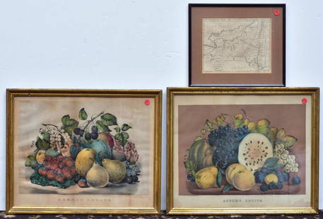
Sold2020Two Currier & Ives PrintsAutumn Fruits and Summer Fruits each 15 1/2" x 19" stone lithographs and a Map of the State of New York by J. Denison, published by Thomas & Andrews, Boston, 1796See Sold Price
Sold20181872 Map and Prints of the Great Boston Fire -- BostonTitle/Content of Map: 1872 Map and Prints of the Great Boston Fire -- Boston Fire Date: 11 30 1872 New York Cartographer: Harper's Weekly Size: 13.5 x 20.5 in. (map) A large, detailed two page bird'sSee Sold Price
Sold2019Italy 1765-1921 Lot of 8 Maps and PrintsLot of 4 Maps and 4 Engravings. Map Examples by Bartholomew, Cornwell and Chambers. Print Examples by Wright, Goldsmith/Shaw, G. Arnald, and Fennings. Two with hand colour. Maps Incl North & South ItaSee Sold Price
Sold2021Two Vintage Car Photographs - Packard and LaSalleTwo Vintage Car Photographs - Packard and LaSalle - Offered Without Reserve1930 Packard roadster photo print by William Plant, framed and matted, image 13.5” x 9”; 1939 LaSalle grille, unkSee Sold Price
Sold2023(2) Texas Maps & Sesquicentennial PrintLot containing (3) framed pieces, to include two (2) Texas related maps, and a signed print celebrating the Texas Sesquicentennial sight: 30 x 25 in., frame: 39 x 33 in. We happily provide seamlessSee Sold Price
4 days LeftJasper52General Map of the West Indies'. West sheet only. Bryan EDWARDS. Caribbean 1794$700
2 days LeftWinter Associates ASIAN: Two 20th C. stands: Chinese style tall plant stand with round top over four elongated$75
2 days LeftWinter Associates Herend and Limoges porcelain, twelve pieces, all marked on base, including: eleven pieces of Herend$150(2 bids)
5 days LeftWeatherham Estate TreasuresBlue-Winged Yellow Swamp-Warbler/Orange-Crowned Swamp-Warbler$20


![Two Prints - A Map & A Plant: Two prints: a map and a plant. [Overall dimensions: 20 x 23 1/2 inches; 22 1/2 x 16 inches].](https://p1.liveauctioneers.com/1221/124522/63572963_1_x.jpg?height=310&quality=70&version=1531512870)


![[MAPS] WYETH. EASTERN/WESTERN HEMISPHERES. 1928: WYETH, N.C. Two map prints. EASTERN HEMISPHERE; WESTERN HEMISPHERE. National Geographic, 1928. Fourth and fifth of a series of five murals by N.C. Wyeth that appeared as frontispieces in several Natio](https://p1.liveauctioneers.com/8124/322212/173235046_1_x.jpg?height=310&quality=70&version=1709937662)


![Two Prints: One with a newspaper, "Yanks Win," and a print of a plant still life. [Each overall: 18" x 15"]. In good condition.](https://p1.liveauctioneers.com/1221/82182/42904603_1_x.jpg?height=310&quality=70&version=1447857677)