Sold2017V Malte-Brun: Carte des Etats-Unis d'Amerique, 1830Map: Carte des Etats-Unis d'Amerique Maker: V Malte-Brun Date: 1830, Brussels/Bruxelles Description: Impactful map of the US, with part of British Columbia shown as US possession. Texas is part of MexSee Sold Price
Sold2019Carte Des Etats-Unis D'ameriqueTitle: Carte Des Etats-Unis D'amerique Date: c1840 Cartographer: THIERRY, sc Size: 8.75Height - 12Width Publisher:MALTE-BRUN ? Reserve: $65.00 Shipping: Domestic: Flat-rate of $18.00 to anywhere withiSee Sold Price
Sold2016Carte des Etats-Unis d'Amerique, du Canada, 1832Map: Carte des Etats-Unis d'Amerique, du Canada, du Nouveau Brunswick et d'une Partie de la Nouvelle Bretagne Cartographer: Pierre M. Lapie Publishing: Paris, 1832 Size: 16 x 20 inches Matted A greatSee Sold Price
Sold2023Carte Des Etats-Unis D'ameriquePublication Date: 1836 Title: Carte Des Etats-Unis D'amerique Cartographer: Bouffard, L. Publisher: Bouffard, L. Height: 12 Width: 15 French railroad map of U.S. west to R. Sabine. Does not show FloriSee Sold Price
Sold2018Map, United States, 1784, first map of the nationMap, United States, 1784,"Carte Des Etats-Unis De L'Amerique Suivant le Traite de Paix de 1783. Dediee et Presentee A.S. Excellence M. Benjamin Franklin Ministre Pleinipotentaire des Etats-Unis", theSee Sold Price
Sold2022(CIVIL WAR.) Jean-Rodolphe Mayer. Nouvelle Carte des Etats-Unis de l'Amerique du Nord… 2de(CIVIL WAR.) Jean-Rodolphe Mayer. Nouvelle Carte des Etats-Unis de l'Amerique du Nord… 2de Edition. Large hand-colored lithographed map of the United States with a keyed reference table numberinSee Sold Price
Sold2022Delamarche - Three Maps of the AmericasCharles Francois Delamarche (1740-1817), including: Amerique Septentrionale; Amerique Meridionale; Carte Des Etats-Unis; published in Paris, each in two sheets, engravings on laid paper with hand coloSee Sold Price
Sold202118TH CENTURY FRENCH MAP OF SOUTHEASTERN USRigobert Bonne (French, 1727-1794). "Carte De la Partie Sud Des Etats Unis De L'Amerique Septentrionale" -circa 1780, engraving. Provenance: From the Lifetime Collection of Billy S. Arant, Jr., ChattaSee Sold Price
Sold2023Carte des Etats-Unis du Mexique & Guatemala. Mexico USA Southwest LAPIE 1829 mapCAPTION PRINTED BELOW PICTURE: Carte des Etats-Unis du Mexique // Carte du Guatemala, ou Provinces-Unies de l'Amérique centrale [The United States of Mexico // Guatemala, or the United ProvincesSee Sold Price
Sold2018CART DU MEXIQUE ET DES ETATS UNIS D'AMERIQUETitle: CART DU MEXIQUE ET DES ETATS UNIS D'AMERIQUE Maker: DEZAUCHE Origin: FRANCE Date/Period: 1783 Materials: COPPER ENGRAVING Dimensions: 48X65CM UPDATED VERSION OF DE L'ISLE'S MAP ENTITLED 'CARTESee Sold Price
Sold2016Map of Canada Framed Vintage 40s Print After 1720Map of Canada Framed Vintage 40-s Print After 1720 Guillaume De L'Isle Carte Du Canada Qui Comprend la Partie Septentrionale Des Etats Unis D'Amerique Canada and Great Lakes Map Approximately 21 5/8"See Sold Price
Sold2018Buchon: Antique Map of USA territorial developmentTITLE/CONTENT OF MAP: 'Carte de l'adjonction progressive des divers états au territoire et à l'union constitutionelle des États-Unis de l'Amérique du Nord 1825' This fascinating map shows the terrSee Sold Price
Sold2023"Carte De La Partie Nord, Des Etats Unis, de L'Amérique Septentrionale" by Rigobert Bonne. Paris,“Carte De La Partie Nord, Des Etats Unis, de l'Amerique Septentrionale” by Rigobert Bonne, Ca. 1780s. This post-revolutionary war map features a detailed overview of the mid-Atlantic regioSee Sold Price
Sold2016Carte Des Etats-Unis, 1856Map: Carte Des Etats-Unis Maker: Louis Etienne Dussieux Date: 1856 Size: Folio - 11 inches high x 15.25 inches wide "Grave par Marlier." U.S. map from his Atlas Generale showing unusual Western territSee Sold Price
Sold2022VOLNEY, CONSTANTIN-FRANCOIS CHASSEBOEUF, comte de Tableau du climat et du sol des Etats-UnisVOLNEY, CONSTANTIN-FRANCOIS CHASSEBOEUF, comte de Tableau du climat et du sol des Etats-Unis d'Amerique. Suivi d'eclaircissemens sur la Floride, sur las colonie francaise au Scioto, sur quelques colonSee Sold Price
Sold2016Carte Genrale Des Etats-Unis Et Du Mexique 1862Map Title: Carte Genrale Des Etats-Unis Et Du Mexique Date: 1862 Publisher: Andriveau-Goujon: Paris Size: 24.3 x 18.25 inches Eastern sheet only. Only east of the Mississippi shown, only Yucatan shownSee Sold Price
Sold2016Tanner map of west 1852 in French pamphetHeading: Author: Tanner, Henry Schenck Title: Carte Des Nouvelle Etats et Territoires annexés aux Etats-Unis Extrait de la carte Génerale des Etats-Unis Publiée New York en 1851 par H. S. Tanner PSee Sold Price
Sold2021Lapie - Carte de Etats Unis d’Amérique du Canada, duArtist: Lapie Title: Carte de Etats Unis d’Amérique du Canada, du Nouveau Brunswick et d’une partie de la Nouvelle Bretagne Description: Lapie - Carte de Etats Unis d’Amérique du Canada, du NoSee Sold Price
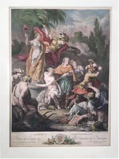
Sold2023Antoine BOREL: Color Engraving by Le VasseurExtremely rare, original 1778 engraving titled "L'Amerique Independante; Dediee au Congres des Etats Unis de l'Amerique" [Independent America; dedicated to the Congress of the United States of AmericaSee Sold Price
Sold20211800 Weld Map of Northern United States and Great LakesTitle: 1800 Weld Map of Northern United States and Great Lakes -- Partie des Etats-Unis de L'Amerique Septentrionale Cartographer: I Weld Year / Place: 1800, Paris Map Dimension (in.): 16.1 X !8.2 in.See Sold Price
Sold20231868 Drioux and Leroy Map of the United States -- Carte Physique et Politique des Etats-Unis, CanadaTitle: 1868 Drioux and Leroy Map of the United States -- Carte Physique et Politique des Etats-Unis, Canada et Partie du Mexique Cartographer: Drioux & Leroy Year / Place: 1868 Map Dimension (in.): 11See Sold Price
Sold2022[CONSTITUTION] DE LA ROCHEFOUCAULD D'ENVILLE, LOUIS ALEXANDRE (Duc de), translator. Constitutions[CONSTITUTION] DE LA ROCHEFOUCAULD D'ENVILLE, LOUIS ALEXANDRE (Duc de), translator. Constitutions des Treize Etats-Unis de L'Amerique. Philadelphia and Paris: [printed for La Rochefoucault and BenjamiSee Sold Price
Sold2024BEN. FRANKLIN CONSTITUTIONS DES TRIEIZE ETATS 1783Constitutions Des Treize Etats-Unis de l'Amerique. Printed 1783 by D. Pierres, Paris. Contains the first printed appearance of the Great Seal of the United States designed by Benjamin Franklin. The FrSee Sold Price
Sold2018Engraved map of Canada and United StatesCarte de la Region Orientale des Etats-Unis et de la dominion du Canada, 19th century, engraved map with hand coloring, designed by A. Brue, overall (with frame): 19.5"h x 25"wSee Sold Price
23 hrs LeftJasper521719 Chatelain Map of Russian Empire -- Carte Generale des Etats du Czar Empereur de Moscovie?$320
23 hrs LeftJasper521719 Chatelain Map of the Adriatic and Venice Republic -- Carte de Geographie des Differents Etats$190
2 days LeftJasper52Isles de la Société. Society Islands. Huaheine Raiatea Polynesia. BONNE 1788 map$35
1 day LeftAdam's AuctioneersMICHAUX, François André [1770-1855] OAKS of the United States and of Canada Philadelphia€500
May 18Ni-Cola Classics - Automobilia Auction & Classic Car SalesPorsche 33-parts books sales catalogs etc. from the 60s-200€70
May 07Hermann Historica GmbHSultan Mohammed V of Morocco - a large-format portrait photo with dedication€260


![[CONSTITUTION] DE LA ROCHEFOUCAULD D'ENVILLE, LOUIS ALEXANDRE (Duc de), translator. Constitutions: [CONSTITUTION] DE LA ROCHEFOUCAULD D'ENVILLE, LOUIS ALEXANDRE (Duc de), translator. Constitutions des Treize Etats-Unis de L'Amerique. Philadelphia and Paris: [printed for La Rochefoucault and Benjami](https://p1.liveauctioneers.com/292/250642/130213472_1_x.jpg?height=310&quality=70&version=1654271664)


![MICHAUX, François André [1770-1855] OAKS of the United States and of Canada Philadelphia (1 of 3)](https://p1.liveauctioneers.com/533/325941/175488532_1_x.jpg?height=282&quality=70&version=1712845571)


