Sold2016c. 1760s, Hand-Colored World Map, “Mappa Mondo”Historic Maps 1760 Hand-Colored World Map, Siena Presso Pazzini Carli c. 1760s, Hand-Colored World Map, “Mappa Mondo,” Printed & Colored by Siena Presso Pazzini Carli, Choice Very Fine. A fine GobSee Sold Price
Sold2018Nichols New York Social Studies Map Denoyer GeppertApprox. 45" x 28". Has 7 pages. All pages are torn.See Sold Price
Sold2017New York State MapNew York State Map ca. 1940 paper/linen/wood/metal 48.13" W x 1.75" D x 64.75" H Vintage New York social studies map manufactured by Denoyer-Geppert Co. of Chicago, IL, with working pull-down mechanisSee Sold Price
Sold202319th & 20th Century Prints of Canada19th and 20th Century color, hand colored, and black and white prints of Canada, including Canadian views and maps, Inuit studies, 19th Century botanical prints, etc. Provenance: Phyllis Lucas GallerySee Sold Price
Sold2017Vanni / Pazzi: Antique Map of Chagres, Panama, 1763Map: Piano della Citta Rada e Porto di Chagre Cartographer: Vanni/Pazzi Place & Date: Livorno / 1763 Size: 7 3/4" x 10 1/4" Condition: overall age toning; minor spotting mostly in margins; small wormSee Sold Price
Sold2022ANDREA VANNI (NACHFOLGER) JUNGFRAU MIT KINDFOLLOWER OF ANDREA VANNI c. 1330 Siena - 2 October 1413 Ibid VIRGIN WITH CHILD Oil on canvas (maroufl.) on wood. 33 x 26,5 cm (F. 37 x 30,5 cm). Part. min. old restored. Framed on velvet cloth. The paSee Sold Price
Sold20171572 Ortelius Map of Tuscany and Siena1572 Ortelius Map of Tuscany and Siena - Senensis Ditionis, Accurata Descrip A. Ortelius 1572 Antwerp 13 x 9.5 in., 20 x 16 in. matted A lovely map of a portion of Tuscany in Italy featuring Siena neaSee Sold Price
Sold2021Francesco VANNI Oil On Canvas OriginalSt. Catherine of Siena by Francesco Vanni. 40 X 29.5. Estimated by Sotheby's in 2011 to be between $5,000-$7,000.See Sold Price
Sold2023Mitchell's School Atlas by Samuel Mitchell. Philadelphia: Thomas, Cowperthwaite & Co., 1839Mitchell's School Atlas was designed for use in schools and aimed to provide students with clear and accurate maps for their geography studies. With its detailed illustrations and concise descriptionsSee Sold Price
Sold2020Mixed Prints & Maps 19th Cent. Lot of 25Lot of 25 Engravings, Etchings and Lithographs. Incl Maps, Botanical, Birds, Ethnic Studies and Genre. Paper Size: Up to 12 x 9.5 inch (30 x 24cm) Quite a few with faults, some in good orderSee Sold Price
Sold2022(8) Books on MapsIncludes "Animal and Maps" ©1969 by Wilma George, "Antique Maps and Their Cartographers"©1970 by Raymond Lister, "Maps, A Historical Survey of Their Study and Collecting"© 1972 bySee Sold Price
Sold2020Mixed Prints C1840-1950 Cent. Lot of 45 PrintsLot of approx 45 Engravings, Collotypes and Lithos. 19th century, but some double sided food prints by Mrs Beeton, C1950. Also Ethnic Studies, Portraits, Natural History, Moule Map, Science etc. PaperSee Sold Price
Sold20173 BIBLES & DICTIONARY OF THE HOLY BIBLE For General3 BIBLES & DICTIONARY OF THE HOLY BIBLE For General Use in The Study of the Scriptures; w/Engr., Maps, & Tables. New York: American Tract Society, Copyr't., 1886; Rev. & enlarged ed., 12mo. Orig. blacSee Sold Price
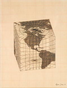
Sold2021Agnes Denes - Study of Distortions; Isometric SystemsLot 3 Agnes Denes Hungarian/American (b. 1931) Study of Distortions; Isometric Systems in Isotropic Space-Map Projections: The Cube (1975) gouache and ink on graph paper and mylar signed lower right sSee Sold Price
Sold2020RARE map of Cairo, Egypt. With Sphinx and pyramids.Title: RARE map of Cairo, Egypt. With Sphinx and pyramids. c1600 by Matteo Florimi. Siena, Italy Date/Period: c1600 Materials: Copper plate engraved Size: 22 1/2 x 16 1/2 inches. Description: Hand colSee Sold Price
Sold20231 Oz 999 Gold European Map Gold Commemorative BarSize: 4.4 cm - 2.8 cm. Weight 28 g. Materials: Iron Plated Gold. Condition: New This type of collectible likely appeals to individuals interested in both numismatics (the study of coins and currency)See Sold Price
Sold20201953 Map of Los Angeles Population Density -- 1953Title: 1953 Map of Los Angeles Population Density -- 1953 Density of Population - Persons per Acre in Study Area by Postal Zones Cartographer: Los Angeles Metro Transit Authority Year / Place: 1953 MaSee Sold Price
Sold20201771 Naples Pompeii Vesuvius and Map TopographyAn interesting study on the "Nature of the Soil of Naples and its Neighborhood", by William Hamilton to the Royal Society. Extracted from Philosophical Transactions for 1771 numbered 1-47 and a largeSee Sold Price
Sold2024Vintage Northeastern U.S. MapVintage map of the Northeastern United States including the triangulation of St. Croix and Hudson Rivers and Lake Ontario. Reproduction of an 1890 study. Provenance: Phyllis Lucas Gallery, NYC. [24" HSee Sold Price
Sold20201765 Paris FRANCE City View Maps Architecture Art1765 Paris FRANCE City View Maps Architecture Art Piganiol ILLUSTRATED A rare geographical study of France by Piganiol! Piganiol de la Force was an 18th-century French author known almost exclusivelySee Sold Price
Sold20201765 Paris FRANCE City View Maps Architecture Art1765 Paris FRANCE City View Maps Architecture Art Piganiol ILLUSTRATED A rare geographical study of France by Piganiol! Piganiol de la Force was an 18th-century French author known almost exclusivelySee Sold Price
Sold20211755 Voyages in France Piganiol Geography Route Maps1755 Voyages in France Piganiol Geography Route Maps French Atlas Dunkirk 2v SET A rare geographical study of France by Piganiol! Piganiol de la Force was an 18th-century French author known almost exSee Sold Price
Sold20201847 Cottage Holy BIBLE Illustrated English KJV MAPS1847 Cottage Holy BIBLE Illustrated English KJV MAPS Civil War 2v SET Polyglott “The Cottage Bible and Family Expositor” was an 1824 study Bible, compiled by Thomas Williams, who used section of tSee Sold Price
5 days LeftTrillium Antique Prints & Rare BooksDe L'Isle - Map of Southern Russia and the Ukraine$75(1 bid)
5 days LeftTrillium Antique Prints & Rare BooksDe L'Isle - Map of Persia (Iran, Iraq, Afghanistan)$75
5 days LeftTrillium Antique Prints & Rare BooksDe L'Isle - Map of China, Tartary and Central Asia including Great Wall of China$75(1 bid)
3 days LeftFreeman's | HindmanHelmut Newton (Australian/German, 1920-2004) Study for Voyeurism II, Los Angeles, 1989$3,000
6 days LeftCurated Gallery AuctionsHudson River School Troll Figure in Tree Study 19th Century Landscape Framed Oil Painting$70(3 bids)
5 days LeftBrunk AuctionsExceptionally Rare Price-Strother Survey of North Carolina Map, c. 1808$60,000
3 days LeftSwann Auction GalleriesHENRY F. WALLING (1825-1889) Map of the City of New York and Its Vicinity. 1866.$1,900
5 days LeftBlock Auction House"Elegy Study" Signed Lithograph on Paper (Robert Motherwell, 1979)$2,150(2 bids)
20 hrs LeftAkiba Galleries18k Gold Mounted Nephrite Sculptural Nature Study (Henrik Wigström) Faberge$2,000(1 bid)
5 days LeftBrunk AuctionsJohn Mitchell - A Map of the British and French Dominions in North America, 1755-1757$24,000
Oct 27Schilb Antiquarian Rare Books1764 OTTOMAN WARS Turkey Murad I Battle of Vienna MAP Hapsburgs Islam Muslim$36(4 bids)