Sold2017von Adrichom: Antique Map of Holy Land / Naphtali, 1584Map: Tribus Neptalim Cartographer: von Adrichom Place & Date: Cologne / 1584 Size: 14 1/2" x 8 1/4" Condition: colored cartouche, town icons and topographical details; overall age toning A map of theSee Sold Price
Sold2018Sanson/Covens & Mortier: Eastern Holy Land, 1730The later Covens & Mortier edition of Sanson's map of the eastern part of the land of Canaan "now Palestine," derived from von Adrichom's Holy Land map (Situs Terrae Promissionis). Oriented with the wSee Sold Price
Sold2019Engraved Map of the Holy Land, 1613Detailed map of the lands of the Tribe of Zabulun, Issachar and Manasseh in the Holy Land, from Christian van Adrichom's Theatrum Terrae Sanctae, first published in 1590 with subsequent edition in 159See Sold Price
Sold2018Charles Wilhem - Binder of Maps of the Holy Land.Karte von Palastina von C.W.M. Van De Velde. Gotha, 1866. Eight color geographic maps depicting various areas of the Land of Israel by cartographer Charles Wilhem. Following a change in Ottoman EmpireSee Sold Price
202316th c. Map, Israel, Middle East - TRIBUS ASER by Christian van AdrichomDescription16th c. Engraved Map of Israel, Middle East - TRIBUS ASER [Territory of the Tribe of Asher in the Holy Land] by Christiaan van Adrichem, (1533-1585) and Arnold Mylius (1540-1604) | PublisheSee Sold Price
Sold2017von Reilly: Map of North America, 1795Map: Karte von Amerika Nach d'Anville und Pownall/Karte von der Republik der Vereinigten Dreyzehen Staaten in Nord Amerika Cartographer: von Reilly Place & Date: Vienna / 1795 Size: 30" x 23" A highlySee Sold Price
Sold2017Map, holy land, Palestine, by Abraham Ortelius, 1612Early map, Palestine, holy land, by Abraham Ortelius, published in Antwerp, 1612, 14.5" by 18.5"See Sold Price
Sold2021Terra Sancta Holy Land Map with the Borders of the 12Terra Sancta Holy Land Map with the Borders of the 12 Tribes of Israel, Nuremberg, 1707. Johann Baptista Homann (German, 1664-1724). Title: Iudaea seu Palaestina ob sacratissima Redemtoris vestigia hoSee Sold Price
Sold20221850 Survey of Holy Land MAPS Jerusalem Bethlehem Canaan Bible Nativity Israel1850 Survey of Holy Land MAPS Jerusalem Bethlehem Canaan Bible Nativity Israel J.T. Bannisters “Survey of the Holy Land” is a rare, mid-19th-century history of Israel and Palestine. In thiSee Sold Price
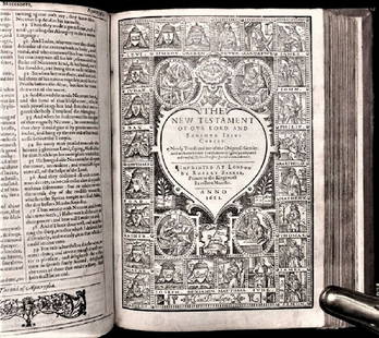
Sold20201612 King James Holy Bible, Genealogy / Map of CanonTHE HOLY BIBLE 1612 This is a very rare 1612 Quartos as there were very few produced to make ready for the 1613 Quartos.See Sold Price
Sold2017Ortelius: Map of Europe, 1584Title: Europae Map maker: Abraham Ortelius Place and Year: Antwerp, 1584 Dimensions: 34.2 x 46 cm (13½ x 18¼ in) Technique: Copperplate engraving Coloring: Hand colored Condition Rating: VG,Some tonSee Sold Price
Sold2016c. 1670 Engraved Holy Land + Mediterranean MapHistoric Maps c. 1670 Engraved Map of the Holy Land & Mediterranean Sea c. 1670, Historic Hand-Colored Engraved Map entitled: “Terra Sancta sive Promissionis olim Palestina recens delineata,” by FSee Sold Price
Sold20231862 CRUSADES History Michaud Holy Wars Jerusalem MAP 4v SET Knights Templar1862 CRUSADES History Michaud Holy Wars Jerusalem MAP 4v SET Knights Templar A rare, 19th-century printing of Joseph-François Michauds “History of the Crusades”. Michauds principal worSee Sold Price
Sold20231748 1ed History of Germany Frankish Carolingian Holy Roman Empire MAPS Barre 5v1748 1ed History of Germany Frankish Carolingian Holy Roman Empire MAPS Barre 5v Joseph Barre was an 18th-century French theologian who today is much better known for his book History of Germany. ThisSee Sold Price
Sold2017Bellin: Antique Map of Louisiana/Mississippi Basin 1750Map: Karte von Luisiana, dem Laufe des Mississippi und den Benachbarten Laendern Cartographer: Bellin Place & Date: Leipzig / 1750 (?) Size: 21 1/2" x 15 1/2" Condition: b&w; overall age toning, a fewSee Sold Price
Sold2019* SPEED, John (1552-1629). Holy Iland / Garnsey / Farne* SPEED, John (1552-1629). Holy Iland / Garnsey / Farne / Iarsey. [London,] 1610 [but 1676]. Hand-colored engraved map of Holy Island and Lindisfarne off the Northumberland Coast, and Guernsey and JerSee Sold Price
Sold2021Manuscript Map of the Holy Land, early 18th Century[Manuscript map of the Holy Land] Pencil, ink, and watercolor on faux vellum with horizontal and vertical folding creases (8 segments) and no mounting guard; pencil grid visible in upper left and righSee Sold Price
Sold2024De Jode, Rare, pub. 1593 - Map of the Holy Land (Descriptio Et Situs Terrae Sanctae Alio NomineThis map of the Holy Land is entitled Descriptio Et Situs Terrae Sanctae Alio Nomine Palestina Multis Preclaris Historys Et Miraculis Utriusque Testamenti A Christo Salvatore nobilitata. The map is beSee Sold Price
Sold20221651 Speed Map of the Holy Land -- Canaan. Begun by Mr. John More Continued and Finished by JohnTitle: 1651 Speed Map of the Holy Land -- Canaan. Begun by Mr. John More Continued and Finished by John Speede Cartographer: J Speed Year / Place: 1651, London Map Dimension (in.): 15.1 X 20.6 in. ThiSee Sold Price
Sold2016Ortelius map of Middle East 1584Heading: Author: Ortelius, Abraham Title: Turcici Imperii Descriptio Place Published: Antwerp Publisher: Date Published: 1579-c.1584 Description: Copper-engraved map, hand-See Sold Price
Sold2020Abraham Ortelius: Antique Map of the Holy Landwith 22 vignettes depicting the story of Abraham 16 1/4" x 20 1/4" sheetSee Sold Price
Sold2021Eleven Antique Maps of EuropeEleven Antique Maps of Europe , 16th-18th c., incl. Ptolemy from 1541 (4); a Blaeu map of "Regno di Napoli", Hondius map of the Holy Land, de Wit map of Southern Spain, an undated manuscript map of MeSee Sold Price
Sold2022(HOLY LAND.) Abraham Ortelius. Terra Sancta.(HOLY LAND.) Abraham Ortelius. Terra Sancta. Double-page engraved map of the Holy Land. 16x21¼ inches sheet size, wide margins, Latin text on verso; original hand-color in full; minor toning andSee Sold Price
Sold2020ORTELIUS, ABRAHAM. Palestinae sive Totius TerraeORTELIUS, ABRAHAM. Palestinae sive Totius Terrae Promissionis Nova Descriptio. Double-page engraved map of the Holy Land. 17½x22¼ inches sheet size, wide margins, Latin text on verso; originSee Sold Price
Jun 23Schilb Antiquarian Rare Books1790 Life of Jesus Christ Fleetwood Bible ART Miracles Jerusalem MAP Holy Land$42(2 bids)
6 days LeftThe Bidder AuctionsJohann Baptista Homann. Terra Sancta Holy Land Map with the Borders of the 12 Tribes of Israel, Hand$100
99 Lots AwayForum AuctionsBible, English. The Holy Bible: Containing The Old Testament and The New, Authorized version, 1640;£150
2 days LeftTrillium Antique Prints & Rare BooksDe Jode, Rare, pub. 1593 - Map of Europe (Nova Totius Europae Tabula)$160(4 bids)
2 days LeftTrillium Antique Prints & Rare BooksDe Jode, Rare, pub. 1593 - Electors of the Holy Roman Empire (Ordines Sacri Romani Imp: Ab Ottone$100(1 bid)
Jun 07Freeman's | Hindman[MAP]. ORTELIUS, Abraham. Presbiteri Iohannis, sive, Abissinorum Imperii Descriptio. 1592.$200
Jun 08Early American History Auctionsc 1730 Hand-Colored Colonial Era Map of the Americas, California shown as an Island, Matted + Framed$500(1 bid)
Jun 09Worthington Galleries19th c. Hemisphere World Map, Hohen und Tiefen der Erde in Lambert’s Zenithal-Projection von$10
Featured5 days LeftJasper521759 HISTORY OF THE WORLD in GERMAN antique ILLUSTRATED w/ MAP of ARABIA vellum$200
Jun 02Schilb Antiquarian Rare Books1871 Holy BIBLE & MAPS Holy Land Hitchcock Analysis Gruden Concordance Theology$120(3 bids)


![16th c. Map, Israel, Middle East - TRIBUS ASER by Christian van Adrichom: Description16th c. Engraved Map of Israel, Middle East - TRIBUS ASER [Territory of the Tribe of Asher in the Holy Land] by Christiaan van Adrichem, (1533-1585) and Arnold Mylius (1540-1604) | Publishe](https://p1.liveauctioneers.com/6084/291748/157234438_1_x.jpg?height=310&quality=70&version=1689539413)


![* SPEED, John (1552-1629). Holy Iland / Garnsey / Farne: * SPEED, John (1552-1629). Holy Iland / Garnsey / Farne / Iarsey. [London,] 1610 [but 1676]. Hand-colored engraved map of Holy Island and Lindisfarne off the Northumberland Coast, and Guernsey and Jer](https://p1.liveauctioneers.com/197/138502/70223743_1_x.jpg?height=310&quality=70&version=1553021481)
![Manuscript Map of the Holy Land, early 18th Century: [Manuscript map of the Holy Land] Pencil, ink, and watercolor on faux vellum with horizontal and vertical folding creases (8 segments) and no mounting guard; pencil grid visible in upper left and righ](https://p1.liveauctioneers.com/1968/225974/116712048_1_x.jpg?height=310&quality=70&version=1636655147)


![[MAP]. SPEED, John. A New Mappe of the Romane Empire. 1676. (1 of 2)](https://p1.liveauctioneers.com/197/329395/177650541_1_x.jpg?height=282&quality=70&version=1715364962)


![[MAP]. ORTELIUS, Abraham. Presbiteri Iohannis, sive, Abissinorum Imperii Descriptio. 1592. (1 of 2)](https://p1.liveauctioneers.com/197/329395/177650536_1_x.jpg?height=282&quality=70&version=1715364962)


