Sold2021Terra Sancta Holy Land Map with the Borders of the 12Terra Sancta Holy Land Map with the Borders of the 12 Tribes of Israel, Nuremberg, 1707. Johann Baptista Homann (German, 1664-1724). Title: Iudaea seu Palaestina ob sacratissima Redemtoris vestigia hoSee Sold Price
Sold2018Harenburg / Homann Heirs: Palestine & Cyprus, 1744Palaestina seu Terra olim Sancta J.C. Harenburg's map of the Holy Land "divided into 12 tribes and extended by Kings David and Solomon," is both highly dramatic and scholarly (Harenburg, clearly had iSee Sold Price
Sold2019Homann's map of the Holy Land, 1707Heading: Author: Homann, Johann Baptiste Title: Iudaea seu Palaestina ob Sacratissima Redemtoris Vestigia Hodie Dicta Terra Sancta Prout Olim in Duodecim Tribus Divisa Separatis ab Invicem Regnis IudSee Sold Price
Sold2019Johann Baptist Homann (1661-1724), "Judaea sevJohann Baptist Homann (1661-1724), "Judaea sev Palaestina Terra Sancta luda et Israel," 18th c., hand colored, H. - 22 in., W. - 19 in.See Sold Price
Sold2016Antique Framed Map of Israel, C. 1748.Ivdaea Sev Palaestina, ... Terra Sancta. By Johann Baptist Homann. Framed, 18.5" x 21.5" sight size. Visible foxing. From a Larchmont NY estate. Dimensions: 23" w x 20" h framed. Condition: Foxing, noSee Sold Price
Sold2016c. 1670 Engraved Holy Land + Mediterranean MapHistoric Maps c. 1670 Engraved Map of the Holy Land & Mediterranean Sea c. 1670, Historic Hand-Colored Engraved Map entitled: “Terra Sancta sive Promissionis olim Palestina recens delineata,” by FSee Sold Price
Sold2021(HOLY LAND.) Johannes Janssonius; and Georg Horn.(HOLY LAND.) Johannes Janssonius; and Georg Horn. [Regions of the 12 Tribes of Israel]. Together six double-page or folding engraved mapsheets to form a large wall map. Folio sheets, a few margins triSee Sold Price
Sold2022(HOLY LAND.) Abraham Ortelius. Terra Sancta.(HOLY LAND.) Abraham Ortelius. Terra Sancta. Double-page engraved map of the Holy Land. 16x21¼ inches sheet size, wide margins, Latin text on verso; original hand-color in full; minor toning andSee Sold Price
Sold2024John Senex (1678-1740) 1710 Map of the Holy Land IsraelJohn Senex ( 1678 - 1740 ) 18th Century Rare 1710 Engraved titled "A Map of the Holy Land " " Divided into the XII Tribes of Israel wherein is exactly marked ye travels of Jesus Christ " Original handSee Sold Price
Sold2021Johann Baptiste Homann MapJohann Baptiste Homann "Amplissimae regionis Mississipi seu Provinciae Ludovicianae...", Nuremberg, 1720, hand-colored map, 19 1/2 in. x 22 5/8 in., framed, together with antique hand-colored map of LSee Sold Price
Sold2022[MAP]. HOMANN, Johann Baptist (1663-1724). Virginia, Marylandia et Carolina in America[MAP]. HOMANN, Johann Baptist (1663-1724). Virginia, Marylandia et Carolina in America Septentrionali. Nuremberg, [ca 1714].   Engraved map of the Mid-Atlantic with hand-coloring in wash and outlSee Sold Price
Sold2023[MAP]. HOMANN, Johann Baptist (1663-1724). Planiglobii Terrestris cum utroq Hemisphaerio[MAP]. HOMANN, Johann Baptist (1663-1724). Planiglobii Terrestris cum utroq Hemisphaerio Caelesti… Nuremberg, [ca 1720]. Engraved double-hemisphere map of the world with hand-coloring in wash anSee Sold Price
Sold2024De Jode, Rare, pub. 1593 - Map of the Holy Land (Descriptio Et Situs Terrae Sanctae Alio NomineThis map of the Holy Land is entitled Descriptio Et Situs Terrae Sanctae Alio Nomine Palestina Multis Preclaris Historys Et Miraculis Utriusque Testamenti A Christo Salvatore nobilitata. The map is beSee Sold Price
Sold2023[MAPS]. HOMANN, Johann Baptist (1663-1724). Four engraved continent maps with hand-coloring, each[MAPS]. HOMANN, Johann Baptist (1663-1724). Four engraved continent maps with hand-coloring, each matted and framed, comprising: Totius Americae… Nuremberg, [ca 1720]. Overall sheet 508 x 590 mmSee Sold Price
Sold2024Exceptional 18th Century Map of The Carolinas, Maryland and VirginiaBy Johann Baptist Homann, Germany, late 17th/early 18th century. Hand colored map of the region which is excellent and quite rare. The map giving excellent details of the region and having exquisite eSee Sold Price
Sold2024Johann B. Homann- Virginia, Marylandia et CarolinaJohann Baptist Homann (German, 1664-1724). "Virginia, Marylandia et Carolina in America septentrionali Britannorum Industria Exclutae," Mid-Eighteenth Century. Double page hand-colored engraved map, pSee Sold Price
Sold2022Homann Atlas Compeniarius, 1748HOMANN, Johann Baptist (1663-1724). Atlas Compeniarius quinquaginta selectarum tabularum geographicarum Homanni. Nuremberg: Heirs of J.B. Homann, 1748 [maps dated 1741-1749]. Folio (21 x 12 inches). ESee Sold Price
Sold2022(9) Mixed Silver Commemorative Coin SetsIncludes: Franklin Mint Genius of Michelangelo (55 coins) Judaic Medal Society 12 tribes of Israel (13 coins) Franklin Mint Zodiac Set (12 coins) Great Men of Medicine (25 coins) Franklin Mint HistSee Sold Price
Sold2022BRITISH ISLES LILY (GEORGE) Britanniae insulae quae nunc Angliae et Scotiae regna continet cum H...BRITISH ISLES LILY (GEORGE) Britanniae insulae quae nunc Angliae et Scotiae regna continet cum Hibernia adiacente nova descriptio, double-page engraved map, land masses hand-coloured, title cartoucheSee Sold Price
Sold2021Manuscript Map of the Holy Land, early 18th Century[Manuscript map of the Holy Land] Pencil, ink, and watercolor on faux vellum with horizontal and vertical folding creases (8 segments) and no mounting guard; pencil grid visible in upper left and righSee Sold Price
Sold20241777 Revolutionary War Map America Septentrionalis1777 hand-colored map published by Homann Heirs, Nuremberg, showing the British colonies in North American, published in the midst of the American Revolution, entitled "America Septentrionalis a DominSee Sold Price
Sold2018Holy Land Pottery Offering Vessel - Iron AgeAncient Near East, Holy Land, Iron Age II, ca. 800 to 500 BCE. A large hand-built terracotta offering vessel with two main components. First is an openwork conical pedestal with a slight concave baseSee Sold Price
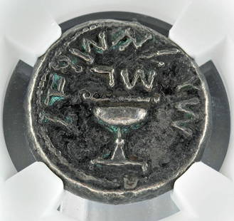
Sold2022Holy Land Judaea Jewish War AR Silver ShekelNear East / Holy Land, Judaea, Jewish War, ca. 66 to 70 CE. AR silver shekel. First revolt, year 3, 68-69 CE. 'Shekel of Israel' (Paleo-Hebrew), ritual chalice with pearled rim, the base raised by proSee Sold Price
Sold2020Middle East.- Roberts (David) The Holy Land, Syria,Middle East.- Roberts (David) The Holy Land, Syria, Idumea, Arabia, Egypt, & Nubia, 6 vol. in 3, 248 tinted lithograph plates (including titles) and 2 engraved maps, occasional light foxing, corner ofSee Sold Price
2 days LeftNye & CompanyJohann Baptista Homann, German 1664-1724, Nova Anglia, Hand-Colored Engraving$250
3 days LeftSwann Auction Galleries(COLONIAL NORTH AMERICA -- NEW ENGLAND.) Johann Baptist Homann. Nova Anglia Septentrionali Americae.$500
Jun 23Schilb Antiquarian Rare Books1790 Life of Jesus Christ Fleetwood Bible ART Miracles Jerusalem MAP Holy Land$105(5 bids)
1 day LeftBill Hood & Sons Art & Antique AuctionsAncient Holy Land Terracotta Cooking Pot, Israel - A terracotta pottery cooking pot with a rounded$175(2 bids)
6 days LeftPalmyra Heritage GalleryAncient Holy Land Iron Age Terracotta Hedgehog c.900-700 BC.$50(2 bids)
5 days LeftCrescent City Auction GalleryHarris G. Strong (American, 1920-2006), "Pair of Ceramic Bulls Facing Off," H.- 12 1/4 in., W.- 18$325
4 days LeftDuMouchellesWilliam H. Gamble (American, B. 1863) Hand Colored Engraving, Ca. 1863, "County Map of Michigan And$50(1 bid)
2 days LeftThe Benefit Shop Foundation Inc.Giovanni De Simone Hand Crafted Ceramic Tray ITALY$20(4 bids)
3 hrs LeftWinter Associates Three historical engraved maps of the Caribbean, ranging from 1616-1814, each hand colored, framed$225(3 bids)
Jun 19Kotler Galleries & AuctioneersJOHANN BERTHELSEN WASHINGTON SQUARE PARK OIL PAINTING Johann Berthelsen Washington Square Park$4,400
3 days LeftSwann Auction Galleries(NEW YORK -- ADIRONDACK MOUNTAINS.) A Map of the Tottin & Crosfields Purchase & the Waters Adjacent$750


![(HOLY LAND.) Johannes Janssonius; and Georg Horn.: (HOLY LAND.) Johannes Janssonius; and Georg Horn. [Regions of the 12 Tribes of Israel]. Together six double-page or folding engraved mapsheets to form a large wall map. Folio sheets, a few margins tri](https://p1.liveauctioneers.com/199/226915/117191999_1_x.jpg?height=310&quality=70&version=1637249113)


![[MAP]. HOMANN, Johann Baptist (1663-1724). Virginia, Marylandia et Carolina in America: [MAP]. HOMANN, Johann Baptist (1663-1724). Virginia, Marylandia et Carolina in America Septentrionali. Nuremberg, [ca 1714].   Engraved map of the Mid-Atlantic with hand-coloring in wash and outl](https://p1.liveauctioneers.com/197/243556/126318973_1_x.jpg?height=310&quality=70&version=1649293172)
![[MAP]. HOMANN, Johann Baptist (1663-1724). Planiglobii Terrestris cum utroq Hemisphaerio: [MAP]. HOMANN, Johann Baptist (1663-1724). Planiglobii Terrestris cum utroq Hemisphaerio Caelesti… Nuremberg, [ca 1720]. Engraved double-hemisphere map of the world with hand-coloring in wash an](https://p1.liveauctioneers.com/197/284572/150193667_1_x.jpg?height=310&quality=70&version=1680880467)

![[MAPS]. HOMANN, Johann Baptist (1663-1724). Four engraved continent maps with hand-coloring, each: [MAPS]. HOMANN, Johann Baptist (1663-1724). Four engraved continent maps with hand-coloring, each matted and framed, comprising: Totius Americae… Nuremberg, [ca 1720]. Overall sheet 508 x 590 mm](https://p1.liveauctioneers.com/197/284572/150193668_1_x.jpg?height=310&quality=70&version=1680880467)


![Homann Atlas Compeniarius, 1748: HOMANN, Johann Baptist (1663-1724). Atlas Compeniarius quinquaginta selectarum tabularum geographicarum Homanni. Nuremberg: Heirs of J.B. Homann, 1748 [maps dated 1741-1749]. Folio (21 x 12 inches). E](https://p1.liveauctioneers.com/1968/250616/130196470_1_x.jpg?height=310&quality=70&version=1654190895)


![Manuscript Map of the Holy Land, early 18th Century: [Manuscript map of the Holy Land] Pencil, ink, and watercolor on faux vellum with horizontal and vertical folding creases (8 segments) and no mounting guard; pencil grid visible in upper left and righ](https://p1.liveauctioneers.com/1968/225974/116712048_1_x.jpg?height=310&quality=70&version=1636655147)


![[Maps & Atlases] Speed, John: Spaine (1 of 2)](https://p1.liveauctioneers.com/65/332523/179335175_1_x.jpg?height=282&quality=70&version=1717709446)


