Sold2021West Indies.- Bahamas.- Allemandy (Victor E.) WondersWest Indies.- Bahamas.- Allemandy (Victor E.) Wonders of the Deep. The Story of the Williamson Expedition, plain and coloured plates, original cloth, mounted colour illustration with one small abrasioSee Sold Price
Sold2021West Indies.- Bahamas.- Shattuck (George Burbank) TheNO RESERVE West Indies.- Bahamas.- Shattuck (George Burbank) The Bahama Islands, half-title, plates, folding map (short tear), folding table, cracked hinges, ex-Ministry of Defence library with bookplSee Sold Price
Sold2022West Indies.- Bahamas.- Shattuck (George Burbank) The Bahama Islands, 1905.West Indies.- Bahamas.- Shattuck (George Burbank) The Bahama Islands, extensively illustrated with plates and maps, some in colour, some folding or double page, errata slip, a few library stamps and iSee Sold Price
Sold2021West Indies.- Bahamas.- Stark (James H.) Stark'sNO RESERVE West Indies.- Bahamas.- Stark (James H.) Stark's History and Guide to the Bahama Islands, plain plates, 2 folding maps, ink ownership inscription to front pastedown, original pictorial boarSee Sold Price
Sold2018GULF OF MEXICO Caribbean West Indies Bahamas. SpanishTITLE/CONTENT OF MAP: 'Map of the Gulf of Mexico, the islands and countries adjacent' This fascinating map shows what was known at the time as the Spanish Main, ie the mainland of the American contineSee Sold Price
Sold2022West Indies.- Bahamas.- Moseley (Mary) The Bahamas Handbook, Nassau, The Nassau Guardian, 1928.NO RESERVE West Indies.- Bahamas.- Moseley (Mary) The Bahamas Handbook, folding maps, photographic plates and illustrations, 26pp. of adverts at rear, endpapers browned, original cloth, spine lightlySee Sold Price
Sold2022Map of West Indies from Mercator 1773"A new general chart for the West Indies of E Wright's projection on Mercator's chart," London: J. Mount & T. Page, ca. 1773. From "The English Pilot. The Fourth Book describing the WesSee Sold Price
Sold2020Map of West Indies from Mercator 1773"A new general chart for the West Indies of E Wright's projection on Mercator's chart," London: J. Mount & T. Page, ca. 1773. From "The English Pilot. The Fourth Book describing the West India NavigatSee Sold Price
Sold2024West Indies Caribbean Florida Bahamas Cuba ADMIRALTY chart 1876 (1949) old mapTITLE/CONTENT OF MAP: 'West Indian Islands and Caribbean Sea - Sheet I - Comprising Florida Strait, Bahama Islands and the Greater Antilles' DATE PRINTED: Surveyed to 1948. Published 1876. New editionSee Sold Price
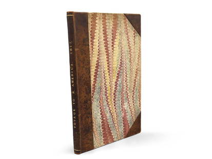
Sold2023Montule: Voyage to North America"A Voyage to North America, and the West Indies in 1817", E. Montule. First edition. London. Printed for Sir Richard Phillips and Co. 1821. 9-1/2in tall x 6in wide. | Philadelphia Metro area delivery,See Sold Price
Sold2018Brion de la Tour: West Indies with Fl. Keys & BahamasReserve Reduced! Map Title: Carte des Isles Antilles dans L'Amérique Septentrionale avec la majeure partie des Isles Lucayes Cartographer: Brion de la Tour / Esnauts et Rapilly Place / Date: Paris /See Sold Price
Sold2019WEST INDIES Antilles Caribbean Cuba Bahamas WindwardTITLE/CONTENT OF MAP: 'THE ANTILLES OR WEST INDIA ISLANDS' DATE PRINTED: 1874 IMAGE SIZE: Approx 32.5 x 42.0cm, 12.75 x 16.5 inches (Large) TYPE: Antique steel engraved map with original outline handSee Sold Price
Sold2023Johnson's West Indies. Bermuda Islands. Caribbean Bahamas Antilles 1866 mapTitle: Johnson's West Indies. Bermuda Islands. Caribbean Bahamas Antilles 1866 map Description: Johnson's West Indies // The Bermuda Islands' by Alvin Jewett Johnson (1866). Large, decorative hand colSee Sold Price
Sold2020(16) MARINE CHARTS & (2) JACK GRAY PRINTS, ROLLEDIncluding: "Windward Passages and Gulf of Mexico, including the Bahamas and West Indies Islands", Wilson, 1899; "Puerto Rico and the Virgin Islands", Imray, 1884; "Massachusetts Bay and the Coast ChatSee Sold Price
Sold20181740 Large Folding Chart Western AtlanticA New Map of Chart of the Western or Atlantic Ocean with part of Europe Africa and America: Shewing the Course of the Galleons, Flota, and C to and from the West Indies, London, printed for E. Cave atSee Sold Price
Sold2024ALBERT E BACKUS FLORIDA & WEST INDIES FOLIO 18Backus, Albert Ernest "Beanie" (1906-1990) Florida Hall of Fame Artist. West Indies Folio with 18 Pencil Sketch Prints - Signed in print. Prints measures 11x14. Outstandingexample of the Original BackSee Sold Price
Sold2019WEST INDIA ISLANDS. Caribbean Indies Antilles Bahamas.TITLE/CONTENT OF MAP: 'West India Islands' Show the West Indies, Antilles, Windward Islands, Leeward Islands, Cuba, the Bahamas, Hispaniola, Turks & Caicos Islands. Vignettes: Kingston, Jamaica, fromSee Sold Price
Sold2023WEST INDIA ISLANDS'. Caribbean Indies Antilles Bahamas. TALLIS/RAPKIN 1851 mapTitle: WEST INDIA ISLANDS'. Caribbean Indies Antilles Bahamas. TALLIS/RAPKIN 1851 map Description: West India Islands' by Map drawn and engraved by J. Rapkin; vignette illustrations drawn by H WarrenSee Sold Price
Sold2021Albert E. Backus Florida & West Indies Litho FolioA Limited Edition portfolio of 17 Indian River School lithograph prints, after Albert Ernest "Beanie" Backus (American, 1907-1997). Produced by the Fort Pierce Arts League. Printed in a limited editioSee Sold Price
Sold2023WEST INDIES. Greater Antilles. Cuba Hispaniola Bahamas 1907 old antique mapTitle: WEST INDIES. Greater Antilles. Cuba Hispaniola Bahamas 1907 old antique map Description: West Indies: Greater Antilles' by Harmsworth (1907). Colour antique map. Scale 1:5,000,000, 23.5 x 35.5cSee Sold Price
Sold2016E O Hoppe: Dutch West IndiesMedium: Sheet-fed Gravure Date: 1922 Printed in London Image Size: 5 x 7 inches Backing Size: 9 x 12 inches Emil Otto Hoppe was a German-born portrait, travel, and land photographer active between 190See Sold Price
Sold2022Antique 1857 West Indies Map of French ColoniesAntique 1857 West Indies Map of French Colonies, original Victor Levasseur map of Colonies Francaises (En-Amerique), gorgeously illustrated map, verso reads MARINO RONCARI Frame Gallery Inc, professioSee Sold Price
Sold20231850 map of W. Indies from Cowperthwait atlasNice example of Cowperthwait map of West Indies. Covers from Florida and the Bahamas south through the Caribbean islands of Cuba and Hispaniola (Haiti & the Dominican Republic) to the northern Part ofSee Sold Price
Sold2018Acrylic Seascape Painting of West Indies ShoreMartinique, A. E. de Bruycket (contemporary), West Indies Cruises, T. S. Hanseatic, Martinique, acrylic on canvas, signed lower right and noted on reverse, 16 x 20, distressed wood frame, 21.25 x 25.2See Sold Price
6 days LeftJasper52WEST INDIA ISLANDS'. Caribbean Indies Antilles Bahamas. TALLIS/RAPKIN 1851 map$120
6 days LeftJasper52Bahamas. San Salvador Crooked Rum Cay Mariguana ADMIRALTY chart 1892 (1919) map$140
May 16Zikorn Arts & History ObjectsWest Indies, Cape Gracias to Belize 1843 British Admiralty Map$100
6 days LeftJasper52GREATER ANTILLES. Cuba Hispaniola Jamaica Bahamas. Haiti Dominican Rep. 1947 map$10
Featured6 days LeftJasper52CARIBBEAN/ATLANTIC ISLANDS.Jamaica Bermuda Bahamas Trinidad. JOHNSTON 1895 map$20
May 16Zikorn Arts & History ObjectsWest Indies Pt. Manzanilla to San Juan 1844 British Admiralty Map$100
6 days LeftJasper52Grand Bahama & Great Abaco Islands. Bahamas. ADMIRALTY sea chart 1886 (1968) map$140
6 days LeftJasper52Bahamas harbours Pelican Abaco Berry I Jumentos ADMIRALTY chart 1899 (1920) map$140
6 days LeftJasper52Cuba, the Bahamas & Bermuda "or Summer Islands". Turks & Caicos THOMSON 1830 map$160
Featured6 days LeftJasper52The Bahamas, Cuba & Bermuda "or Summer Islands". THOMSON 1817 old antique map$180
6 days LeftJasper52Bahamas. Turks & Caicos. New Providence. Nassau plan. 53x67cm. STANFORD 1896 map$360