Sold2024WESTERN ASIA 1190. Saladin's Syrian conquests. Atabegs Kingdom 1160 1902 mapTITLE/CONTENT OF MAP: 'Western Asia at the time of Saladin A.D. 1190; Inset maps of Kingdom of the Atābegs A.D. 1160; Southern Arabia; Syria showing Saladin's Conquests 1187-1190' DATE PRINTED: 1See Sold Price
Sold2024Adirondack Maps (4) [179293]Adirondack Mountains maps (4) from 1902, contained in a nice hardcover jacket. Each map measures 35"x by 27" and each cover different areas. including the northwest, southwest, northeast and southeastSee Sold Price
Sold2020The Western Coast of Louisiana... Coast of New LeonA first state example of the earliest map to focus on the coast of Texas, recognized as the New Kingdom of Leon” This landmark map of the Texas coast presents the area as the Kingdom of Leon,” andSee Sold Price
Sold2024Archibald Knox, Rare Tudric wall clock, model 094Archibald Knox Rare Tudric wall clock, model 094 Liberty & Co.United Kingdom, 1902-05pewter, abalone shell 10.5 h x 10.75 w x 3.75 d in (27 x 27 x 10 cm) Impressed number to verso '0 3'.See Sold Price
Sold2023Webster's Dictionary. First Edition. 1828.Webster, Noah. An American Dictionary of the English Language... To Which are Prefixed, an Introductory Dissertation on the Origin, History and Connection of the Languages of Western Asia and of EuropSee Sold Price
Sold2021Incredible Ancient Persian Tepe Giyan Pottery JarWestern Asia, Persia, Tepe Giyan, Giyan III, ca. 10th to 9th century BCE. Wow! A remarkable and large example of a ceramic vessel from one of Iran's most important ancient cities. The vessel featuresSee Sold Price
Sold2023GEORGE CRAM'S AMERICAN ATLAS OF THE UNITED STATESGEORGE CRAM'S AMERICAN ATLAS OF THE UNITED STATESGeorge F. Cram, proprietor of the Western Map Depot, Chicago, IL, 1878. Color maps within.22.1 x 17.6 in. (56.1 x 44.7 cm.)See Sold Price
Sold2017Rare Scythian 22K+ Gold Button w/ StagWestern Asia, Scythian culture, ca. mid 1st millennium BCE. A gorgeous button or applique made of greater than 22 karat gold. On one side is a simple, looping, tripartite design; on the other is the hSee Sold Price
Sold2021MAP, Western Hemisphere, BlaeuBlaeu's Stunning Carte-a-Figures Map of the Americas in Full Contemporary Color. Western Hemisphere - America. Willem Blaeu, Americae Nova Tabula, 1642 (circa). Hand Color. This stunning carte-a-figurSee Sold Price
Sold2023Chinese Han Lifan Pottery Amphora w/ Bronze, TL Tested**First Time At Auction** East Asia, Western China, Han Dynasty, ca. 206 BCE to 220 CE. A large pottery vase, the surface burnished to a fine grey hue and inlaid with bronze bosses. Panels of incisedSee Sold Price
Sold201719th C. Turkoman Crown- Silver w/ Turquoise & CarnelianWestern Central Asia (Turkmenistan, Iran, Afghanistan, Pakistan, Russia), Turkoman (Turkmen) people, ca. 19th century CE. An absolutely stunning royal crown made of a large, heavy, silver ornament sewSee Sold Price
Sold2020THOMAS SIDNEY COOPER "RESTING SHEEP" OIL, 1879Thomas Sidney Cooper (British / United Kingdom, 1803-1902). "Resting Sheep" - 1879, oil on canvas, signed "T.S. Cooper R.A. and dated lower left. Pastoral painting of a herd of sheep in an open landscSee Sold Price
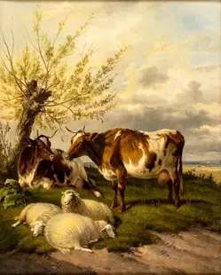
Sold2024Thomas Sidney Cooper (UK,1803-1902) oil painting antiqueARTIST: Thomas Sidney Cooper (United Kingdom, 1803 - 1902) TITLE: Cattle and Sheep at Rest MEDIUM: oil on canvas CONDITION: Overall good. No visible inpaint under UV light. ART SIZE: 16 x 13 inches /See Sold Price
Sold20211721 Map of America With California as an IslandHistoric Maps 1721 Hand-Colored "A New Map of America from the Latest Observations" with "California" Shown as an Island 1721 Hand-Colored Engraved Western Hemisphere Map titled, "A New Map of AmericaSee Sold Price
Sold2022Ortelius 16th Cent. ''Americae Siv Novi Orbis' MapAbraham Ortelius 16th Cent. ''Americae Siv Novi Orbis Nova Descriptio'' Map Engraving. Hand tinted Western Hemisphere map of America circa 1570-73, printed in Antwerp. Gallery framed with glass on botSee Sold Price
Sold2017Chinese Han Dynasty Blackware / Bronze Amphora - TL'dEast Asia, western China, Han Dynasty, ca. 3rd to 2nd century BCE. A black earthenware vessel of incredibly distinctive form, its surface studded with raised bronze shield-like bosses at regular interSee Sold Price
Sold2020Mitchell Map of Western U.S.*** START PRICE IS THE RESERVE *** [America] MITCHELL, Samuel Augustus (1792-1868). A New Map of Texas, Oregon and California with the Regions Adjoining. Engraving with original hand color, with origiSee Sold Price
Sold2018Bleau Map of AsiaBLAEU, Willem Janszoon (1571-1638). Asia Noviter Delineata…Engraved map with original hand color. Amsterdam, c. 1618-1650. 20 x 24 inches sheet, 25 1/8 x 21 3/8 inches framed This is one of the mostSee Sold Price
Sold2024VINTAGE 1959 SCHOOL MAP OF ASIADEMOYER GEPPERT CO. PAPER ON LINEN. PLEASE READ CAREFULLY - Terms for Purchasing and Shipping of Auction Items. Please read carefully before bidding. All payments for purchases will be made through LiSee Sold Price
Sold20239th C. Indian Stone Temple Panel Trimurti & ConsortsSouth Asia, India, Middle Kingdom period, ca. 900 to 1200 CE. A high relief stone panel carving of the Brahmanical Triad, flanked by a female consort, possibly Saraswati, and smaller celestial attendaSee Sold Price
Sold2024Chinese Han Dynasty Bronze Ladle w/ DragonEast Asia, China, Western Han Dynasty, ca. 206 BCE to 220 CE. An elegant bronze ladle featuring an ovoid bowl that swoops upward to a curved handle terminating in a dragon's head finial. The dragon inSee Sold Price
Sold2023Rare 14th C. Philippines Oton Gold Sheet Death MaskSoutheast Asia, Philippines, Western Visayas, ca. 14th to 16th century CE. A remarkable face covering known as an oton, made from 80% to 82% gold (equivalent to 19K+) sheets, cut, and punched with linSee Sold Price
Sold2017Mercator (Gerard) - Atlas sive Cosmographicae,Editio Quinta, engraved pictorial title, prelims, 49 double-page maps, including Asia, Russia, Turkey, Lithuania, Asia Minor and Persia, regions of Italy Spain, Germany and Eastern Europe, and 11 singSee Sold Price
Sold2022Colom's Map of the Western Indian Ocean, c. 1658COLOM, Arnold (1624-1668). Oost Indien van Cabo de Bona Esperanca tot Ceilon. Engraved map with original hand color in outline. Amsterdam, c. 1658. 22 1/4" x 25 1/2" sheet. Colom's Zee Atlas is amongSee Sold Price
214 Lots AwayJasper521696 SYRIA Asia Minor & Syrian-Arabic region HISTORY antique ILLUSTRATED vellum$360
Featured2024Jasper52Puzzle box with wood cubs with maps of the worlds atlas 1890 frenchSee Sold Price
Jun 23Schilb Antiquarian Rare Books1848 Emory Military Reconnaissance 1ed California MAP Indians Texas New Mexico$2(2 bids)
2 days LeftAntique KingdomA Monumental 19th Century French Orientalist Oil On Canvas Painting$240,000


![Adirondack Maps (4) [179293]: Adirondack Mountains maps (4) from 1902, contained in a nice hardcover jacket. Each map measures 35"x by 27" and each cover different areas. including the northwest, southwest, northeast and southeast](https://p1.liveauctioneers.com/2699/324080/174413226_1_x.jpg?height=310&quality=70&version=1711485545)


![Mitchell Map of Western U.S.: *** START PRICE IS THE RESERVE *** [America] MITCHELL, Samuel Augustus (1792-1868). A New Map of Texas, Oregon and California with the Regions Adjoining. Engraving with original hand color, with origi](https://p1.liveauctioneers.com/1968/163248/82424595_1_x.jpg?height=310&quality=70&version=1583340284)


![[MAP]. ORTELIUS, Abraham. Romani Imperii Imago. 1592. (1 of 2)](https://p1.liveauctioneers.com/197/329395/177650537_1_x.jpg?height=282&quality=70&version=1715364962)


