Sold2023Guillaume de l'Isle Map of Germany and Western Europe.‘L'Allemagne, Dressee sur les Obfervations de Tycho-Brahe de Kepler de Snellius’, image 19 x 24.5 inches, engraved by Jean Baptiste Liebaux, c. 1720, hand tinted, framed, 29 x 34.5 incSee Sold Price
Sold2022WW2 'WESTERN FRONT' in 1940. Bird's eye view before invasion of France 1940 mapTITLE/CONTENT OF MAP: 'Daily Mail Air-View Map of the Western Front' DATE PRINTED: 1940 IMAGE SIZE: Approx 97.0 x 74.0cm, 38 x 29 inches (Large) TYPE: Vintage colour map; Scale 10 miles: 1 inch CONDITSee Sold Price
Sold2023Prémière partie de la carte d'Europe'. D'ANVILLE. Western Europe 1756 old mapTITLE/CONTENT OF MAP: 'Prémière partie de la carte d'Europe contenant La France, L'Alemagne, L'Italie, L'Espagne, & les Isles Britanniq.s. Publiée sous les auspices de Monseigneur LouisSee Sold Price
Sold2020Grp: Maps of Western EuropeLot of seven maps of Western Europe. Includes Edward Wells (1667–1727), "A New Map of Present Germany, Shewing Its Principal Divisions, Cities, Towns, Rivers, Mountains, &c. Dedicated to His HiSee Sold Price
Sold20231632 EUROPE DESCRIPTION by MERCURII GALLOBEGICI antique VELLUM BOUND w/ MAPMERCURII GALLOBEGICI sive, rerum in Gallia et Belgio potissimum; Hispania quoqve Italia, Anglia, Germania, Ungaria, Bohemia... Frankfurt; 1632 Illustrated with one plate and the map of Western EuropeSee Sold Price
Sold2022EUROPE. INDUSTRIES. Coal & Iron deposits. British consuls. Railways 1920 mapTITLE/CONTENT OF MAP: 'Central & Western Europe (Industrial)' DATE PRINTED: 1920 IMAGE SIZE: Approx 34.0 x 45.0cm, 13.25 x 17.5 inches (Large) TYPE: Vintage colour map CONDITION: Good; suitable for frSee Sold Price
Sold2018EUROPE. INDUSTRIES. Coal & Iron deposits. BritishTITLE/CONTENT OF MAP: 'Central & Western Europe (Industrial)' DATE: 1920 IMAGE SIZE: Approx 34.0 x 45.0cm, 13.25 x 17.5 inches (Large) TYPE: Vintage colour map CONDITION: Good; suitable for framing. HSee Sold Price
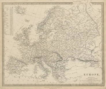
Sold2020Bartholomew, John 1922 Lot of 4 Large Maps. EuropeIncl Europe Political, Orography/Vegetation/Races/Population, Western Europe Politcal, Eastern Political. Large Lithograph Maps Published 1922 by The Times, London for "The Times Survey Atlas of the WSee Sold Price
Sold2022World War 2. Western Europe 6 June 1944. Bomber Offensive/Overlord plan 1959 mapTITLE/CONTENT OF MAP: 'The War in Western Europe - The Combined Bomber Offensive - Overlord, High Command and Plan - German Dispositions, D-Day, 6 June 1944' DATE PRINTED: 1959 IMAGE SIZE: Approx 25.0See Sold Price
Sold2019GRP OF ROAD MAPSGRP OF ROAD MAPS TO INC: (6) FRANCE 1940'S MAPS BY MICHELIN; (9) ESSO/IMPERIAL MAPS OF CANADA, ITALY, ENGLAND, FRANCE, SWITZERLAND, & WESTERN EUROPE; (8) CANADIAN 1952, 1973, 1990-91 MAPS.See Sold Price
Sold2020Antique MapMAP OF GALLIA, ANNO 1598. WESTERN EUROPE, FRENCE.Sheet, 66.8 x 47.5cmMap, 57.3 x 43cmSee Sold Price
Sold2017Mitchell: Antique Map of Asia Verso Europe, 1852Map: 1852 Mitchell Map of Asia -- Asia. Verso: western Europe -- France, Italy, Spain, Portugal and Greece. Cartographer: S Mitchell Year / Place: 1852, Philadelphia Dimensions: 8.2 x 10.5 in. ConditiSee Sold Price
Sold2019Bartholomew, John 1922 Lot of 4 Maps of EuropeIncl Europe Political, Eastern Europe Political, Western Europe Political, and Europe Physical Features & Population. Large Lithograph Maps Published 1922 by The Times, London for "The Times Survey AtSee Sold Price
Sold2020Bartholomew, John 1922 Lot of 4 Maps. EuropeIncl Europe Political, Orography/Vegetation/Races/Population, Western Europe Political, and Eastern Europe Political. Large Lithograph Maps Published 1922 by The Times, London for "The Times Survey AtSee Sold Price
Sold2016Early European Map, Artois, Later Edition of AntwerpEarly European Framed Map, Later edition of Antwerp and Western Europe, Artois, French Edition, by Johanne Surbonio Montenfi, after engraving by Abraham Ortelius after Iacobo Surbonio Montano, circa 1See Sold Price
Sold2020Italy 1747 Antique Map. View of Genoa, Ships"A View of the City of Genoa" Copper Plate Published 1732-85, London for "The London Magazine" Folds as issued. Paper Size: 11.5 x 8 inch (29 x 20cm) Good ConditionSee Sold Price
Sold2021Illuminated Antiphonal LeafWestern Europe, ca. 14th-15th century. An unusually fine example with liquid gold accents and vibrant colors. MEASUREMENTS Dimensions: 11 1/4 inches / 29 cm x 7 3/4 inches / 19.5 cm SHIPPING $15 flat-See Sold Price
Sold2023Gold Ring w/ Ancient Roman Jasper Intaglio Circus MaximusRoman, Imperial Period, ca. 1st to 3rd century CE; Western Europe, Italy, Neoclassical, ca. late 18th to early 19th century CE. A high-quality 72.29% to 73.61% gold (equivalent to 17K+) Neoclassical rSee Sold Price
Sold2020Pan Pacific Exposition Birds-Eye View MapReproduction produced 1968 by First Savings and Loan Association from the original lithograph in the collection of the Society of California Pioneers. Color illustrated birds-eye view: "The ExpositionSee Sold Price
Sold2017Severin (Marc F 1906-1987) Imperial Airways EuropeSeverin (Marc F 1906-1987) Imperial Airways Europe Africa Asia Australia, poster brochure for all Classes of Air Liners, cutaway views, Map of Empire Routes, printed by Ben Johnson May 1934 - 75 x 50See Sold Price
Sold2019Mexique'. Mexico inc Texas, California & western UnitedTITLE/CONTENT OF MAP: 'Carte géographique, statistique et historique du Mexique' The top image on the right hand side shows the entire map. To view a close up of the map showing the level of printedSee Sold Price
Sold2019EUROPE. General map. Inset table of population &TITLE/CONTENT OF MAP: 'EUROPE; inset table of population by country' The top image on the right hand side shows the entire map. To view a close up of the map showing the level of printed detail, pleasSee Sold Price
Sold2018BRITISH INDIA. 'Western States (Scinde Gujerat &c)'.TITLE/CONTENT OF MAP: 'India the Western States (Scinde Gujerat &c.)' The top image on the right hand side shows the entire map. To view a close up of the map showing the level of printed detail, pleaSee Sold Price
Sold2021Barlow 1807 Antique Map. EuropeCopper Engraved Map Published 1807 by Brightly & Kinnersley, Bungay, England for "A General View of the World, Geographical, Historical and Philosophical" by The Rev. E. Blomfield. Engraved by Barlow.See Sold Price
May 16Potter & Potter AuctionsPOLAND, Edwin Christian (1903 – 1991). The Evergreen Playgr...$200
2 days LeftJasper521715 Schenk Map of Western Czechia Around Karlovy Vary -- Geographischer Entwurff der Stadt und$220
2 days LeftDoyle New YorkAn attractive set of Dresser's monumental History of the Birds of Europe$4,000
2 days LeftJasper52Reconnoissance of the Western Coast of the United States from Monterey Bay to The Columbia River in$240
May 09Hunt and Peck Estate Services, Inc.1776 William Burke 1st Ed 2 Volumes "An Account of the European Settlements in America"$100
2 days LeftJasper52Ville and castle of Nograd (Novigrad). Hungary. Antique engraving print from XVII century.$180
May 14Hermann Historica GmbHThree Breton bronze axes type Dahouet, late Bronze Age to early Iron Age of Western Europe, 10th -€400
May 14Hermann Historica GmbHThree Breton bronze axes type Dahouet, late Bronze Age to early Iron Age of western Europe, 10th -€480


![[Western Europe]. 29 Maps & Views. First Image](https://p1.liveauctioneers.com/179/1435/617549_1_x.jpg?height=300&quality=1&width=300)
![[Western Europe]. 29 Maps & Views. First Image](https://p1.liveauctioneers.com/179/1435/617549_1_x.jpg?height=300&quality=95&width=300)