Sold2019EUROPE. General map. Inset table of population &TITLE/CONTENT OF MAP: 'EUROPE; inset table of population by country' The top image on the right hand side shows the entire map. To view a close up of the map showing the level of printed detail, pleasSee Sold Price
Sold2023EUROPE. General map. Inset table of population & density by country. SDUK 1844TITLE/CONTENT OF MAP: 'EUROPE; inset table of population by country' DATE PRINTED: This map was originally published by Baldwin & Cradock in 1836; this date is printed on the map. This edition of theSee Sold Price
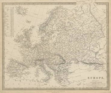
Sold2018SDUK: Antique Map of Europe, 1845TITLE/CONTENT OF MAP: 'EUROPE; inset table of population by country' The map shows Lombardia-Venetia as part of the Austrian Empire, the independent Ionian Islands, and Turkish Crete DATE PRINTED: 184See Sold Price
Sold2023AFRICA. Africa. General Map; Inset map of Population map 1907 old antiqueTITLE/CONTENT OF MAP: 'Africa: General Map; Inset map of Population map' DATE PRINTED: 1907 IMAGE SIZE: Approx 37.0 x 48.5cm, 14.5 x 19.25 inches (Large); Please note that this is a folding map. TYPE:See Sold Price
Sold2018SDUK: Antique General Map of Germany, 1845Title/Content of Map: 'GERMANY, General map' Austria-Hungary & Switzerland. Population table. Date Printed: 1845 Image Size: Approx 34.0 x 41.0cm, 13.25 x 16 inches (Large) Type: Antique steel engraveSee Sold Price
Sold2024WEST ASIA.Arabia Persia Mesopotamia Russia.Rainfall population density 1920 mapTITLE/CONTENT OF MAP: 'Asia (General); Inset map of Siberia; Mongolia' DATE PRINTED: 1920 IMAGE SIZE: Approx 32.5 x 22.0cm, 12.75 x 8.75 inches (Large) TYPE: Vintage colour map; Scale 1:29,500,000 CONSee Sold Price
Sold2022(BERMUDA.) Major General John Henry Lefroy. Map of the Bermudas.(BERMUDA.) Major General John Henry Lefroy. Map of the Bermudas. Hand-colored lithographed wall map of Bermuda with inset diagrams and statistical tables on 4 sheets joined. 51½x60 inches overallSee Sold Price
Sold2023Rare 19thc Map of Russia In Europe, Sweden And NorwayRare 19th Century map of "Russia in Europe, Sweden and Norway" from New General Atlas published by S Augustus Mitchell Jr in Pennsylvania, 1860. Two insets show Denmark, and Holland and Belgium. OrigiSee Sold Price
Sold2023EARLY COLONIAL AFRICA pre Scramble for Africa. Mountains of Kong. LETTS 1883 mapTITLE/CONTENT OF MAP: 'Letts's General map of Africa; Inset map of British Isles' Shows the non-existent Mountains of Kong DATE PRINTED: 1883 IMAGE SIZE: Approx 36.0 x 42.5cm, 14 x 16.75 inches (LargeSee Sold Price
Sold2023EARLY COLONIAL AFRICA pre Scramble for Africa. Mountains of Kong. LETTS 1884 mapTITLE/CONTENT OF MAP: 'Letts's General map of Africa; Inset map of British Isles' Shows the non-existent Mountains of Kong DATE PRINTED: 1884 IMAGE SIZE: Approx 36.0 x 42.5cm, 14 x 16.75 inches (LargeSee Sold Price
Sold2019GERMANY general Map. Central Europe. Hungary.TITLE/CONTENT OF MAP: 'GERMANY, General map' The top image on the right hand side shows the entire map. To view a close up of the map showing the level of printed detail, please click on the bottom imSee Sold Price
Sold20177 Post War Resin German Political Army FiguresExcellent detail to uniforms with no apparent wear. The SA Goering figure has a movable arm. The Lineol copies include 2 Goerings, Blomberg, the map table group General and a SA in Winter coat. The ElSee Sold Price
Sold2018SDUK: Antique Map of North Scotland, 1845Title/Content of Map: 'SCOTLAND, II., North; inset table of former county names' Castles kirks railways. Date Printed: 1845 Image Size: Approx 35.5 x 42.0cm, 14 x 16.5 inches (Large) Type: Antique steSee Sold Price
Sold2022(CUBA.) Francisco Coello. Isla de Cuba.(CUBA.) Francisco Coello. Isla de Cuba. Together two large engraved broadside maps with detailed inset plans, tables, and historical and statistical text panels. Each 32¾x43½ inches overall,See Sold Price
Sold2017Lineol Map Table Gp Table General AdjutantTable with folding legs is excellent with no stains/tears to paper map top. The general with the monacle has no cracks with just some light wear. The adjutant leaning over the table has no cracks andSee Sold Price
Sold2015Jansson (Jan) - [Atlas Novus: Germany],single vol. lacking title, 106 mostly regional maps of Germany and northern Europe, but also including a general map of Germany, and classical maps of both Germany and Scandinavia, and several city plSee Sold Price
Sold2018William Channing Woodbridge MODERN ATLAS ON A NEW PLANWilliam Channing Woodbridge MODERN ATLAS ON A NEW PLAN TO ACCOMPANY THE SYSTEM OF UNIVERSAL GEOGRAPHY 1831 Hand-Colored Maps Tables Charts Political Physical Zoological Population Commerce United StatSee Sold Price
Sold2018SDUK: Antique Map of South Scotland, 1845Title/Content of Map: 'SCOTLAND, I,. South to Perthshire; inset table of former county names' Castles kirks railways. Date Printed: 1845 Image Size: Approx 29.5 x 39.5cm, 11.75 x 15.5 inches (Large) TSee Sold Price
Sold2022Tradition Lot General Lee and His GeneralsAmerican Civil War. General Robert E Lee and His Generals From Set 41. Including J.E.B. Stuart, P. G. T. Beauregard, Stonewall Jackson with Flag and 4 Other Generals. Lacks Table with Maps. 8 Pieces.See Sold Price
Sold2018ENGLAND & WALES NORTH. Railways companies canals coachTITLE/CONTENT OF MAP: 'General Railway map-Northern Section; Inset map of Manchester' This map is folding hence the centrefold line may show on the image below DATE PRINTED: 1903 IMAGE SIZE: Approx 44See Sold Price
Sold2022(RAILROADS.) J.W. Orr. Map of the All-Rail Great Southern Mail Route.(RAILROADS.) J.W. Orr. Map of the All-Rail Great Southern Mail Route. Small lithographed map of railroad connections from New York to the southern states printed in blue with an inset table of distancSee Sold Price
Sold2024Mahogany Low Table Inset with 17th C. Style Dutch Map, 35"W.Mahogany Low Table Inset with 17th C. Style Dutch Map, 35"W.See Sold Price
Sold2018Bartholomew's Large Scale Map of Central Europe.Title/Content of Map: Bartholomew's Large Scale Map of Central Europe. Date Printed: 1914 Cartographer: BARTHOLOMEW, JOHN & CO. Size: 23.5x35.25 [cover title] "General map showing European frontiers,See Sold Price
Sold2019The Times 1895 Lot of 7 Maps of EuropeIncl Constantinople, Religions of Europe, Ethnographic Map of the Balkan Peninsula, Greece, Southern Scandinavia, Mediterranean Sea, and General Map of the Alps. Lithograph Maps Published 1895, LondonSee Sold Price
5 days LeftJasper52EUROPE. General map. Inset table of population & density by country . SDUK 1844$20
5 days LeftJasper52Turkey in Europe. Balkans Bosphorus Rumania Rumelia. 50x60cm. JOHNSTON 1879 map$20
5 days LeftJasper52EUROPE. Austrian Empire Prussia Poland. Slave market pic. RAPKIN/TALLIS 1851 map$100
Featured5 days LeftJasper52MEDITERRANEAN PORTS. Marseille Gibraltar Valetta Naples Algiers Piraeus 1903 map$30
Featured5 days LeftJasper52SOUTHERN EUROPE & MEDITERRANEAN. inset Gibraltar & Malta. BARTHOLOMEW 1898 map$20
5 days LeftJasper52North Sea sea chart. Ports lighthouses mail routes. UK Norway &c LARGE 1952 map$40
5 days LeftJasper52North Sea & Baltic. Cables Wireless Stns Land visibility Shipping lines 1952 map$40
Featured5 days LeftJasper52Austro-Hungarian Monarchy (West) Vienna Austria. 50x60cm. JOHNSTON 1879 map$20


![Jansson (Jan) - [Atlas Novus: Germany],: single vol. lacking title, 106 mostly regional maps of Germany and northern Europe, but also including a general map of Germany, and classical maps of both Germany and Scandinavia, and several city pl](https://p1.liveauctioneers.com/410/80717/41962763_1_x.jpg?height=310&quality=70&version=1445353131)


![Bartholomew's Large Scale Map of Central Europe.: Title/Content of Map: Bartholomew's Large Scale Map of Central Europe. Date Printed: 1914 Cartographer: BARTHOLOMEW, JOHN & CO. Size: 23.5x35.25 [cover title] "General map showing European frontiers,](https://p1.liveauctioneers.com/5584/120928/61572013_1_x.jpg?height=310&quality=70&version=1524615138)


