Sold2018William Channing Woodbridge MODERN ATLAS ON A NEW PLANWilliam Channing Woodbridge MODERN ATLAS ON A NEW PLAN TO ACCOMPANY THE SYSTEM OF UNIVERSAL GEOGRAPHY 1831 Hand-Colored Maps Tables Charts Political Physical Zoological Population Commerce United StatSee Sold Price
Sold20221831 Woodbridge School Atlas -- Modern School Atlas on a New Plan...Title: 1831 Woodbridge School Atlas -- Modern School Atlas on a New Plan... Cartographer: W Woodbridge Year / Place: 1831, Hartford Map Dimension (in.): 11.9 X 9.7 in. This is an outstanding and uncomSee Sold Price
Sold2015Woodbridge ...ATLAS ON A NEW PLAN... 1828. 9 maps.[Atlas] William C. Woodbridge. SCHOOL ATLAS TO ACCOMPANY WOODBRIDGE’S RUDIMENTS OF GEOGRAPHY. ATLAS ON A NEW PLAN, EXHIBITING THE PREVAILING RELIGIONS, FORMS OF GOVERNMENT, DEGREES OF CIVILIZATION,See Sold Price
Sold2023Woodbridge's School Atlas (Oliver Cooke, 1830)Woodbridge's School Atlas, To Accompany the Rudiments of Georgraphy. Atlas on a new plan, exhibiting the Prevailing Religions, Forms of Government, Degrees of Civilization, and the comparative size ofSee Sold Price
Sold2023Hall, William 1789 Folio Print. Ship Deck Plan. Naval ArchitectureCopper Plate Published 1789-91 by C. Cooke, London for "The New Royal Encyclopedia, Or, Complete Modern Universal Dictionary of Arts and Sciences..." by William Henry Hall. Paper Size: 15 x 9.5 inch (See Sold Price
Sold2020Hall, William 1791 Lot of 4 Folio Scicence/Tech PrintsIncl Perspective, Husbandry, Diving Bell/Hydraulics and The Art of War Fort Plan. Copper Plates Published 1789-91 by C. Cooke, London for "The New Royal Encyclopedia, Or, Complete Modern Universal DicSee Sold Price
Sold2020Hall, William 1791 Pair of Folio Fortification PlansCopper Plates Published 1789-91 by C. Cooke, London for "The New Royal Encyclopedia, Or, Complete Modern Universal Dictionary of Arts and Sciences..." by William Henry Hall. Paper Size: 15 x 9.5 inchSee Sold Price
Sold202310pc Modern Trains GroupIncludes a Williams 20305 GM Demonstrator BL2 Diesel, lightly run; 47452, 47453, 47055, 47720; Menards 279-5335, 279-6278, K-line 648001, Atlas Industrial 1002301 & 100103-1. Cars appear like new or lSee Sold Price
Sold2024Very Rare Mexico Nova Hispania 1579 Hand Colored MapORTELIUS, Abraham (1527-1598). Theatrum Orbis Terrarum. 1570. It is considered to be the first modern atlas. Map of New Spain (Mexico), 1579. Printed in Antwerp by Christophe Plantin (1588). Etching.See Sold Price
Sold2019Williams modern O gauge brass New York Central HudsonWilliams modern O gauge brass New York Central Hudson steam locomotive , c10, . Reserve: $279.20 Shipping: Domestic: Flat-rate of $35.00 to anywhere within the contiguous U.S. International: Flat-rateSee Sold Price
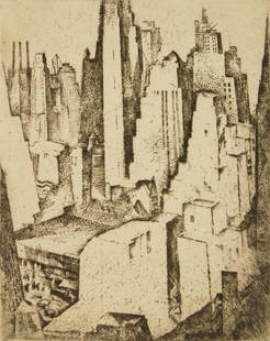
Sold2021William Meyerowitz etchingWilliam Meyerowitz (American 1887-1981)- ''Modern New York''- etching, 1928, signed in pencil, edition of 50, minor ink stains in margins otherwise very good condition. 10 x 8''See Sold Price
Sold2020Atlas - Philip, George 1938 School Atlas, Many Maps"Philips' New Modern School Atlas of Comparative Geography" by George Philip and George Goodall. London: George Philip & London Geographical Institute, 1938. 4to (290 x 230mm) Complete with 96 NumbereSee Sold Price
Sold2023Eggleston, William; Ancient and Modern [1992 1ST EDITION - NEW COPY STILL SEALED IN ORIGINALNew York: Random House, 1992. Hardcover in pictorial dust jacket. First Edition, First Printing. Fine copy of stated first U. S. edition in fine Brodarted dust jacket. 167 pages. Over 160 stunning colSee Sold Price
Sold2019Samuel Augustus Mitchell (1790-1868), "Plan of NewSamuel Augustus Mitchell (1790-1868), "Plan of New York," 1866, Atlas, H.- 15 3/4 in., W.- 12 3/8 in.See Sold Price
Sold2017Woodbridge: Antique Map of North America & West IndiesWOODBRIDGE, W.C. . London: Whittaker, 1821. From "Modern Atlas". Approximately 8-1/2 x 10-1/2, in plastic sleeve. Right margin a little close trimmed (no loss of image), else fine. Depicts the North ASee Sold Price
Sold2023Civil War LIFE CAREER DAVID FARRAGUT Headley 1865 juvenile bioHeadley, Phineas Camp; Life and Naval Career of Vice-Admiral David Glascoe Farragut (Young Americans History of Modern Heroes); New York: William H Appleton 1865. 342 pages. Hardcover. Military BiogrSee Sold Price
Sold2024Art Books, Mondrian, American, Renoir, MatisseMondrian by Hans LC Jaffe, Harry N Abrams publishers, 1985. The Art of Assemblage by William C Seitz, Museum of Modern Art New York, second printing 1968. American Folk Painters of Three Centuries, HuSee Sold Price
Sold2024Mark TobeyMark Tobey, 1962, William C. Seitz, The Museum of Modern Art, New York, softbound.See Sold Price
Sold2019Modern Atlas Of 14 Maps-1826,14 hand colored fldg mapsTitle: Modern Atlas Of 14 Maps-1826,14 hand colored fldg maps Provenance: By Hart, Joseph C. About this Item: R. Lockwood, New York, 1826. Hardcover. Condition: VG. Second Edition. Very rare in this cSee Sold Price
Sold2022John Senex Map of Louisiana & Mississippi River 1721John Senex (English, 1678-1740). "Map of Louisiana and the River Mississippi," from "A New General Atlas," London, 1721. Dedicated to William Law of Lanreston. This map is an EngliSee Sold Price
2016Royal Atlas of Modern Geography by Alexander JohnstonTitle: Royal Atlas of Modern Geograph By Alexander Keith Johnston Publisher: William Blackwood and Sons Date: 1884 No Reserve: This lot starts at $1 and has no reserve as a courtesy so that collectorsSee Sold Price
Sold2023Tallis, John 1851 Portrait Print. Captain James Cook. AustraliaSteel Engraving Published 1851 by John Tallis, London & New York for "The Illustrated Atlas, and Modern History of the World" by Robert Montgomery Martin. Paper Size: 11 x 7 inch (28 x 18cm) Good CondSee Sold Price
Sold2017Boxed Williams Southern Pacific 7002 Cab ForwardWilliams modern O gauge #7002 Southern Pacific brass cab forward steam locomotive in original box. Loco features smoke, brass construction, electronic reverse, etc. Untested, appears new in box, stillSee Sold Price
Sold2023MAPS IN BOOK, France, Le RougeIncludes Plans of New Orleans and Quebec. France, Atlases. Le Rouge, Recueil des Fortifications Forts et Ports de Mer de France Lave au Pinceau, 1760 (circa). Black & White. This book contains 89 platSee Sold Price
4 days LeftJasper52Bahamas. Turks & Caicos. New Providence. Nassau plan. 53x67cm. STANFORD 1896 map$360
May 17Albion AuctionsStieler, Adolf 1909 Antique Map. New Zealand - South Sea Islands, Pacific Australia Hawaii$5
5 days LeftForum AuctionsBurroughs (William S.) Nova Express, first edition, New York, 1964 & others, modern American fiction£75


![Woodbridge ...ATLAS ON A NEW PLAN... 1828. 9 maps.: [Atlas] William C. Woodbridge. SCHOOL ATLAS TO ACCOMPANY WOODBRIDGE’S RUDIMENTS OF GEOGRAPHY. ATLAS ON A NEW PLAN, EXHIBITING THE PREVAILING RELIGIONS, FORMS OF GOVERNMENT, DEGREES OF CIVILIZATION,](https://p1.liveauctioneers.com/179/82189/42599738_1_x.jpg?height=310&quality=70&version=1447864785)