Sold2022Map of "The State of Massachusetts from the Best Information 1796"Map of "The State of Massachusetts from the Best Information 1796," hand colored copper engraving, published by J. Reid, New York from John Reid's American Atlas the second folio-sized atlas publishedSee Sold Price
Sold2016Map of Massachusetts from The Best InformationMap: The State of Massachusetts from The Best Information Maker: J. Low, Teibout Anderson Size: Octavo - 7.5 inches high x 9.25 inches wide Date: 1799 Engraved for a geography and bearing notation aloSee Sold Price
Sold2018The State of New York, Compiled from the most AuthenticTitle/Content of Map: The State of New York, Compiled from the most Authentic Information. 1796. Cartographer: D. Martin Height (inches): 15.25 Width (inches): 18Year: 1796 Martin Sculpt.Curious earlySee Sold Price
Sold2018JOHN REID (AMERICAN, 18TH/19TH CENTURY) MAP OF VIRGINIAJOHN REID (AMERICAN, 18TH/19TH CENTURY) MAP OF VIRGINIA, on laid paper, title in oval cartouche to upper left corner "the STATE of / VIRGINIA / from the best Authorities / 1796", above "Published by JSee Sold Price
Sold2019[Map] The State of South Carolina 1796Tanner, Benjamin. "The State of South Carolina: from the best Authorities." New York: John Reid, [ca. 1796.] On heavy laid. Measuring from neat-lines 17" x 15". Lower edge remargined, mild toning, oneSee Sold Price
Sold2018Tanner / Reid Map of South Carolina, 1796Tanner, Benjamin (1775-1848). State of South Carolina from the Best Authorities. Engraved map. J. Reid, 1796. 15" x 17" sheet. Published by John Reid New York. A very early and scarce folio map of SouSee Sold Price
Sold2022Three 18th Century North Carolina Mapsengravings on laid paper, all unframed, including: John Reid, The State of North Carolina From the Best Authorities, engraver Benjamin Tanner, New York, circa 1796, sheet 16-1/2 x 19 in.; Matthew CareSee Sold Price
Sold2017Thomas & Andrews: Antique Map of Massachusetts, 1796Map: Massachusetts Date: 1796 Medium: Original copperplate engraving From Morse's Universal Geography by Thomas & Andrews, Boston, 1796 Dimensions: 15" x 12.5" Unframed. Please note that this lot hasSee Sold Price
Sold2022Antique Map "The State of Massachusetts"Antique Map "The State of Massachusetts", matted and framed in a bird's eye maple frame with gilt rosette corners 14 in. x 19.75 in. Framed 23.75 in. x 28.5 in.See Sold Price
Sold2020NebraskaTitle: Nebraska Prublication Date: 1899 Cartographer: CRAM, GEORGE F. Publisher: GEO. F. CRAM Size: 16.25Height - 22.25Width Additional Information: State map with all railroads color coded. From CramSee Sold Price
Sold2021Rare California tourist booklet with maps 1930Heading: (California) Author: Title: Motourist Maps: Western States Tourist Information Place Published: South Gate, CA Publisher:Burt Hard & Company Date Published: c.1930 DescriptionSee Sold Price
Sold20201869 Mitchell Map of Atlantic States from MassachusettsTitle/Content of Map: 1869 Mitchell Map of Atlantic States from Massachusetts to Delaware [verso] Map of New York, New Jersey, Pennsylvania & Delaware -- IX Massachusetts, Rhode Island and ConnecticutSee Sold Price
Sold2020Vintage Sterling Charm Bracelet with 14 Sterling Charms1971's, head marked stacy, car, cowboy hat, scroll, roller skates, softball, sweet 16, arazona state map, baton, Massachusetts map, california map, cross/heart/anchor, girl in prom gown, & 1971See Sold Price
Sold2017Bradford: Antique Map of Massachusetts, 18351835 Bradford map of Massachusetts. Nice early map of the state of Massachusetts by Thomas Gamaliel Bradford. Original hand coloring. Clean with good margins. 7.5 x 10 inches. Thomas G. Bradford was tSee Sold Price
Sold20201876 Mitchell Map of Massachusetts, Connecticut andTitle/Content of Map: 1876 Mitchell Map of Massachusetts, Connecticut and Rhode Island -- County and Township Map of the States of Massachusetts Connecticut and Rhode Island Cartographer: S Mitchell YSee Sold Price
Sold2017[Railroads] Northern Pacific Map, 1891"Northern Pacific R. R." St. Paul, Spring and Summer, 1891. Folding map with blue lithographed outer covers, verso with ads, schedules, and other information. Map with states bordered in color. UnfoldSee Sold Price
Sold20231926 Tony Sarg Colored Lithograph Map of Nantucket in the State of Massachusetts1926 Tony Sarg (1880-1942) Colored Lithograph Map of Nantucket in the State of Massachusetts, depicting founders of Nantucket Island and numerous landmarks, matted and framed Sight 16 in. x 18.5 in. OSee Sold Price
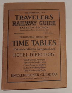
Sold20241915 Traveler's Guide Eastern US. A 344 page bookA 5 3/4" by 8" soft cover book with railroad timetables and other travel information: hotel ads, city, state maps, etc. Paper is supple and not pulpy.See Sold Price
Sold2024Carey, pub. 1796 - Map of the State of MarylandThis fine map engraving is from one of the ealiest American atlases published in the states: Mathew Carey's General Atlas. The work was published in Philadelphia by Carey in 1796. It was an importantSee Sold Price
Sold2016Map of the World from the Best Authorities. 1796Map: Map of the World from the Best Authorities Maker: Amos Doolittle Date: 1796 Publisher: Thomas and Andrews, Boston Size: Oblong Octavo, 7.00 inches wide "Doolittle Sculp. Engraved for Morse's UnivSee Sold Price
Sold20181796 State of Rhode Island Hand Colored MapNew York,Dated 1796 Map of the State of Rhode Island as updated by the latest surveys,1796, hand colored on laid paper, engraved for the American edition of Winterbothams America, published by John ReSee Sold Price
Sold2019State of New YorkTitle: State of New York Publication Date: 1809 Cartographer: LEWIS, SAMUEL Publisher: MATHEW CAREY Size: 16.1Height - 20.6Width compiled from the best authorities. 1809… Interesting early state mapSee Sold Price
Sold2022Massachusetts Travel Historic Vacationland Collectable MapState of Massachusetts travel foldout map from the World's Fair. The map when pulled out is approx 34" x 21" and when folded up, is approx 5 1/8" x 8 1/2". The map is in a good, vintage condition withSee Sold Price
Sold2023New Ideal Atlas of New Jersey and Pennsylvania. Chicago: Rand McNally, 1913"New Ideal Atlas of New Jersey and Pennsylvania" is a comprehensive reference work providing detailed maps and information on the two states, including information on topography, transportation systemSee Sold Price
3 days LeftJasper521864 Johnson Map of Massachusetts, Connecticut and Rhode Island -- Johnson's Massachusetts,US$60
Jun 07Freeman's | Hindman[MAP]. ORTELIUS, Abraham. Americae Sive Novi Orbis, Nova Descriptio. 1573.US$1,000
1 day LeftSchilb Antiquarian Rare Books1869 American Emigrants Immigration Illustrated US State MAPS Railroad AlaskaUS$3(2 bids)
21 hrs LeftMorgan AuctionsJames Abbott McNeill Whistler "Nocturne in Black and Gold, The Falling Rocket, 1875" PrintUS$150
5 days LeftPotter & Potter AuctionsArmour’s Food Source Map / The Greatness of the United Stat...US$200
1 day LeftSchilb Antiquarian Rare Books1883 FLORIDA for Tourists & Settlers Illustrated Fort Barrancas MAP Fine BINDINGUS$90(5 bids)
1 day LeftSchilb Antiquarian Rare Books1865 State of VIRGINIA Jones Colonial America INDIANS Negroes Slaves #28/50US$72(4 bids)
1 hr LeftConsortium LLCThe Beatles "Yesterday and Today" Butcher Cover Second State Record/LPUS$350(1 bid)


![[Map] The State of South Carolina 1796: Tanner, Benjamin. "The State of South Carolina: from the best Authorities." New York: John Reid, [ca. 1796.] On heavy laid. Measuring from neat-lines 17" x 15". Lower edge remargined, mild toning, one](https://p1.liveauctioneers.com/3532/146911/74242458_1_x.jpg?height=310&quality=70&version=1564368564)


![1869 Mitchell Map of Atlantic States from Massachusetts: Title/Content of Map: 1869 Mitchell Map of Atlantic States from Massachusetts to Delaware [verso] Map of New York, New Jersey, Pennsylvania & Delaware -- IX Massachusetts, Rhode Island and Connecticut](https://p1.liveauctioneers.com/5584/178208/89700132_1_x.jpg?height=310&quality=70&version=1599603893)


![[Railroads] Northern Pacific Map, 1891: "Northern Pacific R. R." St. Paul, Spring and Summer, 1891. Folding map with blue lithographed outer covers, verso with ads, schedules, and other information. Map with states bordered in color. Unfold](https://p1.liveauctioneers.com/3532/111460/57224262_1_x.jpg?height=310&quality=70&version=1509131847)


![[MAP]. ORTELIUS, Abraham. Americae Sive Novi Orbis, Nova Descriptio. 1573. (1 of 2)](https://p1.liveauctioneers.com/197/329395/177650534_1_x.jpg?height=282&quality=70&version=1715364962)


