Sold2024Robert Morden (British, 1650-1703) Map AssortmentRobert Morden (British, 1650-1703) Map Assortment (5) items including (4) by Morden pulled from Gibson's edition of 'Camden's Britannia', first Morden edition, published by Abel Swale and John ChurchiSee Sold Price
Sold2023Britanna Romana Antique Hand Colored Map by Robert Morden, 1722Britanna Romana antique hand colored map. Originally by Robert Morden (1650 – 1703). Map depicting British Isles from Camden's Britannia, there is a fold in the middle where it was folded intoSee Sold Price
Sold20222 PC. FRAMED EARLY ENGLISH MAPS2 PC. FRAMED EARLY ENGLISH MAPS: Comprising; 1- Hand-colored Oxford Shire map, by Robert Morden. 1- An accurate map of the county of Bedford divided into its hundreds. Drawn from a late survey, & illuSee Sold Price
Sold2015A FRAMED BRITISH HAND COLORED COPPER PLATE CARTOGRAPHICA FRAMED BRITISH HAND COLORED COPPER PLATE CARTOGRAPHIC ENGRAVING OF THE BRITISH ISLES, AFTER ROBERT MORDEN (British 1650-1703) "BRITANNIA, OR A CHOROGRAPHICAL DESCRIPTION OF GREAT BRITAIN AND IRELANDSee Sold Price
Sold2017ROBERT MORDEN (ENGLISH 1650-1703), HAND COLOREDROBERT MORDEN (ENGLISH 1650-1703), HAND COLORED ENGRAVED MAP OF SURREY, SIGNED. SIGHT 14 3/4 X 17 1/2"; FRAMED AND GLAZED-16 X 18 1/2"See Sold Price
Sold2024Two Antique Maps of Buckingham Shire & SpitsbergenTwo antique maps, larger of which is on laid linen paper, and depicts Spitsbergen island in Norway. Measures approx. 12.25" x 61". Smaller map is of Buckingham Shire by Robert Morden.See Sold Price
Sold2022MAP, England, MordenEastern England. Robert Morden, Huntington Shire, from Britannia, 1695 (circa). Black & White. This county map of Huntingdonshire and Cambridgeshire shows the early road system. The map is divided intSee Sold Price
Sold2017Robert Morden - English Plantations in AmericaRobert Morden (d. 1703) and William Berry (fl. 1669-1708) makers A New Map of the English Plantations in America both Continent and Ilands Shewing their true Situation and distance from England or oneSee Sold Price
Sold2022Scarce 1695 map of Wilt Shire with Stone Henge by Robert MordenScarce copper engraved original antique map by Robert Morden from the 1695 Atlas to Accompany Camden’s Britannia with decorative cartouche and enhanced with later hand coloring. Stone Henge circSee Sold Price
Sold2018Morden: Antique Map of Shropshire, 1772Shropshire: 'SHROP SHIRE' by ROBERT MORDEN from Camden's Britannia, 1772 map Date: 1772 IMAGE SIZE: Approx 38.5 x 45.0cm, 15.25 x 17.75 inches (Large); Please note that this is a folding map. TYPE: DoSee Sold Price
Sold2022[ANTIQUE MAPS] MORDEN - WEST RIDING YORKSHIRE 1695[ANTIQUE MAP] MORDEN, Robert. 'THE WEST RIDING OF YORK SHIRE' BY ROBERT MORDEN C.1695 41X35cm. Hand-coloured. Frame not included. Map will be removed from frame and securely shipped in cardboard tube.See Sold Price
Sold2022Camden's Britannia with Robert Morden mapsHeading: Author: Camden, William Title: Britannia: or a chorographical description of Great Britain and Ireland, together with the adjacent islands Place Published: London Publisher:James and John KnSee Sold Price
Sold2020MORDEN, ROBERT. A New Map of New England and New York.MORDEN, ROBERT. A New Map of New England and New York. Small-scale engraved map of New England on a folio leaf of English text. 8x6½ inches sheet size; preceding text leaf tipped to verso. - LondSee Sold Price
Sold2018* MORDEN, Robert (ca 1650-1703). Geography Rectified:* MORDEN, Robert (ca 1650-1703). Geography Rectified: or, A Description of the World. London: for Robert Morden and Thomas Cockeril, 1680. Small 4to (200 x 157 mm). Title printed in red and black, hanSee Sold Price
Sold2024Anglia Scotia Hibernia 1699 by Heinrich Scherer. British Isles 1703 old mapCAPTION PRINTED BELOW PICTURE: 'Anglia Scotia Hibernia 1699' DATE PRINTED: 1703 IMAGE SIZE: Approx 25.5 x 37.0cm, 10 x 14.75 inches (Large) TYPE: Hand coloured antique 18th century map CONDITION: GoodSee Sold Price
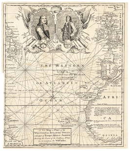
Sold20171740 Ornate Copperplate Engraved Portrait MapHistoric Maps 1740 Ornate Copperplate Engraved Map with Portraits of British Admirals “Robert Blake” & “Edward Vernon, Esq.” 1740-Dated, Copperplate Engraved Map titled “A New Map or Chart oSee Sold Price
Sold2018Morden: Antique Map of Florida & the Great Lakes, 16931693 map of Florida and the Great Lakes by Robert Morden. 5 x 5 inches. A very special map--one of the very earliest obtainable English maps of the American colonies. A Map of Florida and Ye Great LakSee Sold Price
Sold2021A 1687 Map of Pennsylvania and New JerseyRobert Morden, London, published by Modern and Cockerill in 1687. From the "Atlas Terrestris". Purchased from the Philadelphia Print Shop. Dimensions: Sight is 5 3/4" x 4 3/4", the frame 12 1/4" x 11See Sold Price
Sold2024Gordon, Patrick Geography Anatomiz'dGeography Anatomiz'd Or, The Compleat Geographical Grammar... London: Robert Morden, 1699. Second edition, 8vo in fours, 15 (of 16) maps, lacking the world map, several maps hand-coloured in outline,See Sold Price
Sold2023Laurie & Whittle Map of the British Colonies of North AmericaLAURIE, Robert (1755-1836), and WHITTLE, James (1757-1818). A New and Correct Map of the British Colonies in North America comprehending Eastern Canada...with the adjacent states of New England. EngraSee Sold Price
Sold2023Laurie & Whittle Map of the Southern British Colonies of AmericaLAURIE, Robert (1755-1836), and WHITTLE, James (1757-1818). A New and General Map of the Southern Dominions belonging to the United States of America... Engraved map with original hand color in outlinSee Sold Price
Sold2022Wilson (Lt. Col. Robert Thomas) History of the British Expedition to Egypt, first edition, 1802.Wilson (Lt. Col. Robert Thomas) History of the British Expedition to Egypt, first edition, engraved portrait frontispiece, 3 folding maps, very occasional light browning or foxing, modern half calf, rSee Sold Price
Sold20241905 VOYAGE of DISCOVERY VOLS antique ILLUSTRATED British Antarctic explorationSCOTT, Robert Falcon (1868-1912). The Voyage of the ‘Discovery’. London: John Murray, 1905 2 volumes Photogravure frontispieces, 12 color-printed plates, 5 maps (2 folding in rear pocket), numerouSee Sold Price
Sold2021ATTRIB., DAVID ROBERTS (British. 1796-1864) WATERCOLORExposed Egyptian Temple Façade with Figures and Goats. Unsigned. Watercolor on Paper. 40 by 34 in. (Cond: approx. 7 in. tear from center top down, partly repaired, small creases to margins, corners,See Sold Price
Jul 07Worthington GalleriesFirst Edition Hand-colored Map THE NORTH RIDING OF YORKSHIRE by Robert MordenUS$20
2 days LeftForum AuctionsCodrington (Robert) His Majesties Propriety, and Dominion on the British Seas asserted, first£100
Jul 14Schilb Antiquarian Rare Books1914 Arctic Voyage SCOTT Terra Nova ANTARCTICA Expedition Color Illustrated MAPSUS$62(4 bids)
2 days LeftJulien's AuctionsDuke of Kent | 1900 Commemorative Linen Scarf With South Africa Map And PoemUS$50(1 bid)
Jul 14Taylor & HarrisRobert Crozier (UK 1815-1891) Oil on Canvas Painting Blue Boy after GainsboroughUS$2,500
BonhamsPEARY'S COPY OF AN EARLY NORTH AMERICAN MAP. PEARY, ROBERT E. 1856-1920.] DOBBS, ARTHUR. 1689-17...US$1,600(7 bids)
Featured1 day LeftJasper52Fine Victorian Oil Painting Children Collecting Wood in Rural Lane, signed 19th centuryUS$850
10 hrs LeftLunds Auctioneers & Appraisers Ltd.Book & Map: "Some Account of the British Dominions Beyond the Atlantic", 1776, William DCA$1,100(2 bids)
2 hrs LeftFreeman's | Hindman[Maps & Atlases] A New Map of North America, with the West India Islands...US$300
1 day LeftUniversity ArchivesBritish Courtier in 1616 Member of Parliament Apologizes to Viscount Who Later Became the 1st EarlUS$140(2 bids)


![[ANTIQUE MAPS] MORDEN - WEST RIDING YORKSHIRE 1695: [ANTIQUE MAP] MORDEN, Robert. 'THE WEST RIDING OF YORK SHIRE' BY ROBERT MORDEN C.1695 41X35cm. Hand-coloured. Frame not included. Map will be removed from frame and securely shipped in cardboard tube.](https://p1.liveauctioneers.com/8321/253807/131946549_1_x.jpg?height=310&quality=70&version=1657218937)


![PEARY'S COPY OF AN EARLY NORTH AMERICAN MAP. PEARY, ROBERT E. 1856-1920.] DOBBS, ARTHUR. 1689-17... (1 of 3)](https://p1.liveauctioneers.com/1043/333441/180036747_1_x.jpg?height=282&quality=70&version=1719180533)


![[Maps & Atlases] A New Map of North America, with the West India Islands... (1 of 2)](https://p1.liveauctioneers.com/65/332523/179335173_1_x.jpg?height=282&quality=70&version=1717709447)


