Sold2023Lizars, Daniel 1831 LG Rare HC Map. World on Mercator's ProjectionLarge Folio Copper Engraved Map Published 1831-2 by John Hamilton, Successor to Daniel Lizars, Edinburgh for "The Edinburgh Geographical and Historical Atlas..." First Edition by Daniel Lizars. Very fSee Sold Price
Sold2022ZATTA, ANTONIO. Il Mappamondo o sia Descrizione Generale Del Globo Ridotto in Quadro.ZATTA, ANTONIO. Il Mappamondo o sia Descrizione Generale Del Globo Ridotto in Quadro. Double-page engraved map of the world on Mercator's projection with the title cartouche incorporating a small terrSee Sold Price
Sold2018* BELLIN, Jacques Nicholas (1703-1772). Essay d'une* BELLIN, Jacques Nicholas (1703-1772). Essay d'une Carte Reduite, Contenant les Parties Connuees du Globe Terrestre. Paris, 1748. Engraved map of the world on Mercator's projection, image 500 x 700 mSee Sold Price
Sold2021Encyclo. Britannica C1830 Map of The WorldThe World on Mercator's Projection. Steel Engraved Map Published 1830-42, Edinburgh for "Encyclopedia Britannica" Seventh Edition. Centre fold as issued. Paper Size: 16 x 11 inch (40 x 28cm) Minor tonSee Sold Price
Sold2017Tallis World Map World on Mercator's Projection 1851Tallis World Map The World on Mercator's Projection 1851 . J. Tallis, 1851 London, 10.5 X 14 In.. This Is a Decorative and Striking Steel Engraved World Map That Was Produced from the Same Plate UsedSee Sold Price
Sold2021Guthrie, William 1798 Map World of Mercators ProjectionCopper Engraved Map Published 1798, London for "A New Geographical, Historical and Commercial Grammar..." by William Guthrie. The maps are by John Senex, Thomas Kitchin and others. Folds as issued. PaSee Sold Price
Sold2023Becker, F. P. C1845 Antique Map. World on Mercators ProjectionSteel Engraved Map Published C1845, London for "A Complete and Universal English Dictionary" by the Rev. James Barclay and B. B. Woodward. Maps by F. P. Becker. Outline hand color. Paper Size: 11 x 8See Sold Price
Sold2022Brewster, David 1830 Antique Map. World on Mercator's Projection"Charte of the World on Mercator's Projection with the dip and variation of the Compass. The Trade Winds & Monsoons" Copper Engraved Map Published 1808-1830, Edinburgh for "The Edinburgh EncyclopaediaSee Sold Price
Sold2022Guthrie, William 1805 Map. World on Mercators ProjectionCopper Engraved Map Published 1805, London for "A New Geographical, Historical and Commercial Grammar..." by William Guthrie. Folds as issued. Paper Size: 10.5 x 8 inch (27 x 21cm) Approx. Some toningSee Sold Price
Sold2022Rapkin, John 1860 Map. World on Mercators ProjectionSteel Engraved Map Published 1860 by The London Printing & Published Company, London for "The Royal Dictionary-Cyclopedia for Universal Reference" by Thomas Wright. Drawn & Engraved by John Rapkin. FoSee Sold Price
Sold2022Guthrie, William 1812 Map. World on Mercator's ProjectionCopper Engraved Map Published 1812, London for "A New Geographical, Historical and Commercial Grammar..." by William Guthrie. Folds as issued. Paper Size: 14 x 8 inch (36 x 21cm) Approx. Some toning/oSee Sold Price
Sold2020Rapkin, John 1860 Map. World on Mercator's ProjectionSteel Engraved Map Published 1860 by The London Printing & Published Company, London for "The Royal Dictionary-Cyclopedia for Universal Reference" by Thomas Wright. Drawn & Engraved by John Rapkin. FoSee Sold Price
Sold2020Rapkin, John 1860 Map. World on Mercator's ProjectionSteel Engraved Map Published 1860 by The London Printing & Published Company, London for "The Royal Dictionary-Cyclopedia for Universal Reference" by Thomas Wright. Drawn & Engraved by John Rapkin. FoSee Sold Price
Sold2023Nat. Encyclo. 1890's Large Map. World on Mercator's ProjectionSteel Engraved Map Published 1891-1901 by William Mackenzie, London for "The National Encyclopedia: A dictionary of Universal Knowledge" Folds as issued. Paper Size: 20.5 x 13.5 inch (52 x 33cm) A couSee Sold Price
Sold2022MAP "THE WORLD ON MERCATOR'S PROJECTION SHEWING THE VOYAGE OF CAPTAIN COOK ROUND THE WORLD." CircaMAP "THE WORLD ON MERCATOR'S PROJECTION SHEWING THE VOYAGE OF CAPTAIN COOK ROUND THE WORLD."Circa 1800Published by The London Printing and Publishing Company. Engraved for R. Montgomery MartSee Sold Price
Sold2023General Chart on Mercators Projection. World. Cook's route. PAYNE 1798 old mapTITLE/CONTENT OF MAP: 'General Chart on Mercators Projection' DATE PRINTED: 1798 IMAGE SIZE: Approx 18.0 x 25.0cm, 7 x 9.75 inches (Medium) TYPE: Antique copperplate engraved map with original hand coSee Sold Price
Sold2017Chart of the World on Mercators ProjectionCirca 1796 Lot of 2 Antique World Maps; Titles: "Chart of the World on Mercators Projection" (Doolittle, sculp.) Approximate size: 11" x 8-3/8". "Map of the World from the best Authorities" (DoolittleSee Sold Price
Sold20241775-1780 World on Mercator projection. By Bonne & RaynalTitle: 1775-1780 World on Mercator projection. By Bonne & Raynal Date/Period: 1775-1780 Materials: Copperplate engraved Size: 10” x 14 1/2” This antique map, created by R. Bonne and RaynalSee Sold Price
Sold2015Map of The World on Mercators Projection by Allen Bell,Original engraving of The World on Mercators Projection by Allen Bell & Company, London 1837. Dimensions: 14 “ x 18 1/2”See Sold Price
Sold2024Kitchin Map of the World with the New Discoveries on Mercator's Projection 1783KITCHIN, Thomas (1718-1784)). Map of the World with the New Discoveries on Mercator's Projection. Engraved map. London: Cadell, 1783. 14 3/4" x 20 7/8" sheet. This map presents an interesting view ofSee Sold Price
Sold2020Johnson's World on Mercator's Projectionworld map, framed, cracked glass, 16 1/2"x25"See Sold Price
Sold2019Walker, John 1795 Map of the World on Mercators Proj."General Chart on Mercators Projection" Copper Engraved Map Published 1795, London for "Elements of Geography, and of Natural and Civil History" by John Walker. Centre fold as published. Paper Size: 1See Sold Price
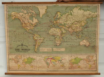
Sold2015Bacon's Excelsior Map of The WorldOn Mercator's Projection, printed in London by G. W. Bacon & Co., Ltd., circa 1880. Chromolithograph laid on canvas with both original wood hangers. 39 1/2" x 30".See Sold Price
Sold2023Mercator, Rumold (1545-1599) World MapAn engraved double-page double hemispheric world map, "Orbis Terrae Compendiosa Descriptio". Dimensions:Sight is 11 1/4" x 20 3/4", the frame 21" x 29 1/2". Provenance:From a Philadelphia Collection.See Sold Price
May 09Hunt and Peck Estate Services, Inc.Chart Of The World According To Mercators Projection Showing Tracks & Discoveries Of Capt. Cook$140
4 days LeftJasper521699 Moll World Map with Cowley's Voyages -- Nouvelle Carte du Monde Suivant l'idee de Mercator ou$240
4 days LeftJasper52Rand, McNally & Co.'S Map of the Western Hemisphere. Globe Series Compiled from the Latest And Most$340
114 Lots AwayLeland LittleThucydides's History of the Peloponnesian War in Greek and Latin, with Folding Maps$200(3 bids)
BonhamsDARWIN'S FIRST BOOK. DARWIN, CHARLES. 1809-1882. Journal of Researches into the Geology and Natu...$9,000
Featured5 days LeftJasper52Bismarck Archipelago New Guinea New Britain 1943/4. Ports. World War 2 1961 map$8
5 days LeftDoyle New YorkA highly detailed map of New England after the Jansson-Visscher series$250(2 bids)