Sold2021Boating maps, the Jumentos Cays end drag at IslandMaps from 1981 tropic Isle publishers, Inc By Harry Kline, The Jumentos Cays in Ragan Island harbour, French wells and turtle sound, crooked Acklins islands. Size 11“ x 17“See Sold Price
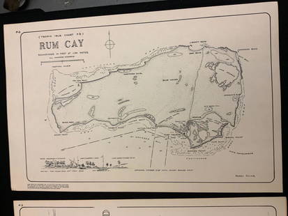
Sold2021Boating maps, rum cay, conception island, San Salvador.Maps from 1981 tropic Isle publishers, Inc By Harry Kline, Rum Cay, Conception island, San Salvador. Size 11“ x 17“See Sold Price
Sold2021Boating maps, Spanish wells to Harbor Island, cays toMaps from 1981 tropic Isle publishers, Inc By Harry Kline, Spanish wells to Harbor Island, cays to Eleuthera, current cut and current settlement. Size 11“ x 17“See Sold Price
Sold2021Boating Maps, Long Island, Long Island north end, eastMaps from 1981 tropic Isle publishers, Inc. by Harry Klein, Long Island, Long Island Northwynn, East Coast harbors. Size, 11” x17”See Sold Price
Sold2021Boating maps, harbors creeks cat Island, Turks andMaps from 1981 tropic Isle publishers, Inc By Harry Kline, Harbors creeks cat Island, Turks end Caicos Islands. 11“ x 17“See Sold Price
Sold2021Boating maps, Nassau Harbour, New Providence Island,Maps from 1981 tropic Isle publishers, Inc By Harry Kline, Nassau Harbour, new Providence Island, Little Harbor and alder cay anchorages. Size 11“ x 17“See Sold Price
Sold2021Boating Maps, west end, green turtle to Hope-town,Maps from 1981 tropic Isle publishers, Inc By Harry Kline, west end Grand Bahama, Green turtle to Hopetown, cistern cay to bitter guana cay. Size 11“ x 17“See Sold Price
Sold2021Boating maps, crooked island district, little SanMaps from 1981 tropic Isle publishers, Inc By Harry Kline, Crooked island district, little San Salvador little island or little cat island, cat island and little San Salvador. Size 11“ x 17̶See Sold Price
Sold2021Boating maps, royal island harbor, egg islands, currentMaps from 1981 tropic Isle publishers, Inc By Harry Kline, Royal island harbor, egg Islands, current island Anchorage. Size 11“ x 17“See Sold Price
Sold2021Boating Maps, Brock cay to channel cay, bitter guanaMaps from 1981 tropic Isle publishers, Inc, by Harry Kline, Brock Cay to Channel Cay, Bitter Guana Cay to Brock Cay, Bimini Cat Cay. size, 11“ x 17“See Sold Price
Sold2021Boating maps, Southern Berry islands, Central BerryMaps from 1981 tropic Isle publishers, Inc By Harry Kline, Southern Berry Islands, Central Berry islands, Northern Berry islands. Size 11“ x 17“See Sold Price
Sold2021Boating Maps, central Bahamas, farmers cay galliot cutMaps from 1981 tropic Isle publishers, Inc by Harry Klein, Central Bahamas, farmers Cay galliot cut, size 11“ x 17“See Sold Price
Sold2021Boating Maps, Bahamas for out islands, The BahamaMaps from 1981 tropic Isle publishers, Inc By Harry Klein, Bahamas far out islands, The Bahama Islands, airstrip locations.See Sold Price
Sold2021Boating maps, western New Providence, rose island,Maps from 1981 tropic Isle publishers, Inc By Harry Kline, Western New Providence, rose Island, eastern approaches to Nassau harbour. Size 11“ x 17“See Sold Price
Sold2021Boating Maps, hub of Abaco, man-of-war cay to CherokeeMaps from 1981 tropic Isle publishers, Inc By Harry Kline hub of Abaco, man-of-war cay to. Cherokee sound, marsh Harbour size 11“ x 17“See Sold Price
Sold2021Boating Maps, sail rocks to cistern cay, spaniel cay,Maps from 1981 tropic Isle publishers, Inc By Harry Kline, sale rocks to cistern Cay, staniel cay, allans cay harbour. Size 11“ x 17“See Sold Price
Sold2021Boating maps, Powell Point to rock sound, EleutheraMaps from 1981 tropic Isle publishers, Inc By Harry Kline, Powell point to rock sound, Eleuthera island, Spanish wells and ridley head channel. Size 11“ x 17“See Sold Price
Sold2021Boating maps, The brights of intros, Stafford Creek toMaps from 1981 tropic Isle publishers, Inc By Harry Kline, The brights of andros, Stafford Creek to North bright, jousters cays to Stanford creek. Size 11“ x 17“See Sold Price
Sold2021Boating Maps, Elizabeth Harbor, Pike Creek, ElizabethMaps from 1981 tropic Isle publishers inc, by Harry Klein, Elizabeth Harbor, pipe Creek, Elizabeth Harbor to hog Cay, size 11“ x 17“See Sold Price
Sold2021antique map dated 1856Rare antique map of Anacapa Island and east end of Santa Cruz Island, California, dated 1856, 9.25"x26"See Sold Price
Sold2023Antique Map of Hell Gate and East River - 1887Original, extremely rare first edition map (1887), full title "Hell Gate and East River from S. End of Blackwell's Island to Lawrence's Point including Little Hell Gate and Mouth of Harlem River." ProSee Sold Price
Sold2016John Smith, Deer Island M.E. MapFramed copy of a map. "U.S. Coast Survey, A.D. Bache Supt. Eastern End of Deer Island Surveyed in June 1863". [37" x 39 1/4" H]. Creased and wear.See Sold Price
Sold2017Lotter: Antique Map of Greece & Aegean Islands, 1770Map: Graecia Nova et Mare Aegeum Cartographer: Conrad Lotter Place & Date: Augsburg / 1770 (circa) Size: 22 3/4" x 19 3/4" Condition: repair at lower end of fold with minor loss at the bottom center bSee Sold Price
4 days LeftJasper52A Topographical Map of the northn. part of New York Island… FADEN/STEDMAN 1794$3,200
Oct 06Schilb Antiquarian Rare Books1790 French Revolutions de Paris Prudhomme Illustrated MAPS of FRANCE Departments$42(2 bids)
14 hrs LeftKey Date Coins*EXCLUSIVE* Hand Marked "Unc Peace Standard," x10 coin Covered End Roll! - Huge Vault Hoard (FC)$400(2 bids)
3 hrs LeftKey Date CoinsNEW! *Watchmaker’s Hoard* Original Covered End Mills Novelty Co. Mixed Lincoln Wheat Cent Roll 1c$20
4 days LeftForum AuctionsAtlas.- Jamieson (Alexander) A Celestial Atlas, comprising a Systematic Display of the Heavens in a£600
7 hrs LeftPeterborough Auctions LLCRobert Hogg Nisbet (1879-1961) Across the Railroad Tracks$50(1 bid)
6 hrs LeftNY Elizabeth ERNEST FLOYER'S 1882 UNEXPLORED BALUCHISTAN ANTIQUE MAP ILLUSTRATED IN ENGLISH$50
4 days LeftForum AuctionsWorld.- Blaeu (Johannes) Nova et Accuratissima Totius Terrarum Orbis Tabula Auctore Joanne Blaeu,£7,000
Oct 12JM Hobby Supply and Railroad Artifact AuctionsChicago Rock Island and Pacific RY-1884 Watt-Stephen Genius of Steam Book$40


![John Smith, Deer Island M.E. Map: Framed copy of a map. "U.S. Coast Survey, A.D. Bache Supt. Eastern End of Deer Island Surveyed in June 1863". [37" x 39 1/4" H]. Creased and wear.](https://p1.liveauctioneers.com/1221/96236/49410667_1_x.jpg?height=310&quality=70&version=1478883947)


