Sold2021Boating maps, Allen’s Highborne, The Bahamas,Maps from 1981 tropic Isle publishers, Inc By Harry Kline, Allen’s highborn, The Bahamas, South Bright to hawksbill Creek, size 11“ x 17“See Sold Price
Sold2021Boating Maps, Bahamas for out islands, The BahamaMaps from 1981 tropic Isle publishers, Inc By Harry Klein, Bahamas far out islands, The Bahama Islands, airstrip locations.See Sold Price
Sold2021Boating Maps, central Bahamas, farmers cay galliot cutMaps from 1981 tropic Isle publishers, Inc by Harry Klein, Central Bahamas, farmers Cay galliot cut, size 11“ x 17“See Sold Price
Sold2021Boating maps, Powell Point to rock sound, EleutheraMaps from 1981 tropic Isle publishers, Inc By Harry Kline, Powell point to rock sound, Eleuthera island, Spanish wells and ridley head channel. Size 11“ x 17“See Sold Price
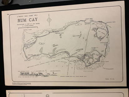
Sold2021Boating maps, rum cay, conception island, San Salvador.Maps from 1981 tropic Isle publishers, Inc By Harry Kline, Rum Cay, Conception island, San Salvador. Size 11“ x 17“See Sold Price
Sold2021Boating maps, Spanish wells to Harbor Island, cays toMaps from 1981 tropic Isle publishers, Inc By Harry Kline, Spanish wells to Harbor Island, cays to Eleuthera, current cut and current settlement. Size 11“ x 17“See Sold Price
Sold2021Boating Maps, Brock cay to channel cay, bitter guanaMaps from 1981 tropic Isle publishers, Inc, by Harry Kline, Brock Cay to Channel Cay, Bitter Guana Cay to Brock Cay, Bimini Cat Cay. size, 11“ x 17“See Sold Price
Sold2021Boating maps, Southern Berry islands, Central BerryMaps from 1981 tropic Isle publishers, Inc By Harry Kline, Southern Berry Islands, Central Berry islands, Northern Berry islands. Size 11“ x 17“See Sold Price
Sold2021Boating maps, The brights of intros, Stafford Creek toMaps from 1981 tropic Isle publishers, Inc By Harry Kline, The brights of andros, Stafford Creek to North bright, jousters cays to Stanford creek. Size 11“ x 17“See Sold Price
Sold2021Boating maps, Nassau Harbour, New Providence Island,Maps from 1981 tropic Isle publishers, Inc By Harry Kline, Nassau Harbour, new Providence Island, Little Harbor and alder cay anchorages. Size 11“ x 17“See Sold Price
Sold2021Boating maps, governors HBR, hatchet bay, northMaps from 1981 tropic Isle publishers, Inc By Harry Kline, governors HPR, hatchet bay, north EleutheraSee Sold Price
Sold2021Boating Maps, hub of Abaco, man-of-war cay to CherokeeMaps from 1981 tropic Isle publishers, Inc By Harry Kline hub of Abaco, man-of-war cay to. Cherokee sound, marsh Harbour size 11“ x 17“See Sold Price
Sold2021Boating Maps, Elizabeth Harbor, Pike Creek, ElizabethMaps from 1981 tropic Isle publishers inc, by Harry Klein, Elizabeth Harbor, pipe Creek, Elizabeth Harbor to hog Cay, size 11“ x 17“See Sold Price
Sold2021Boating maps, the Jumentos Cays end drag at IslandMaps from 1981 tropic Isle publishers, Inc By Harry Kline, The Jumentos Cays in Ragan Island harbour, French wells and turtle sound, crooked Acklins islands. Size 11“ x 17“See Sold Price
Sold2021Boating Maps, Long Island, Long Island north end, eastMaps from 1981 tropic Isle publishers, Inc. by Harry Klein, Long Island, Long Island Northwynn, East Coast harbors. Size, 11” x17”See Sold Price
Sold2021Boating maps, harbors creeks cat Island, Turks andMaps from 1981 tropic Isle publishers, Inc By Harry Kline, Harbors creeks cat Island, Turks end Caicos Islands. 11“ x 17“See Sold Price
Sold2021Boating Maps, sail rocks to cistern cay, spaniel cay,Maps from 1981 tropic Isle publishers, Inc By Harry Kline, sale rocks to cistern Cay, staniel cay, allans cay harbour. Size 11“ x 17“See Sold Price
Sold2021Boating maps, western New Providence, rose island,Maps from 1981 tropic Isle publishers, Inc By Harry Kline, Western New Providence, rose Island, eastern approaches to Nassau harbour. Size 11“ x 17“See Sold Price
Sold2021Boating maps, crooked island district, little SanMaps from 1981 tropic Isle publishers, Inc By Harry Kline, Crooked island district, little San Salvador little island or little cat island, cat island and little San Salvador. Size 11“ x 17̶See Sold Price
Sold2021Boating maps, royal island harbor, egg islands, currentMaps from 1981 tropic Isle publishers, Inc By Harry Kline, Royal island harbor, egg Islands, current island Anchorage. Size 11“ x 17“See Sold Price
Sold2021Boating Maps, west end, green turtle to Hope-town,Maps from 1981 tropic Isle publishers, Inc By Harry Kline, west end Grand Bahama, Green turtle to Hopetown, cistern cay to bitter guana cay. Size 11“ x 17“See Sold Price
Sold2017Mallet: Antique Map of Isles Lucayes, Bahamas, 1683Title/Content of Map: 'Isles Lucayes' The east coast of Florida is on the left hand side of the map. Part of Cuba is shown at the bottom of the map. Bahamas, Abacoa Lucaioneque Curateo Ciguateo Date PSee Sold Price
Sold2019MAP - Hispaniola & Bahamas. BellinNorthern Hispaniola & Southern Bahamas. Jacques Nicolas Bellin, Carte Reduite des Debouquemens de St. Domingue Dressee pour le Service des Vaisseaux du Roy..., 1768 (dated). Hand Color. This large-scaSee Sold Price
Jun 25Freeman's | Hindman[Maps & Atlases] Oliva, Joan: Portolan Chart of the Mediterranean$10,000(1 bid)
6 days LeftCurated Gallery AuctionsAntique American Hudson River School Fall Landscape Framed Boating Scene Original Oil Painting$20(2 bids)
24 hrs LeftDOYLE Auctioneers & AppraisersSet of Twelve Satirical Anthropomorphic Maps of Europe$400(1 bid)
6 days LeftSchilb Antiquarian Rare Books1855 San Francisco 1st ed California Gold Rush Illustrated MAPS Soule Indians$13(4 bids)
6 days LeftSchilb Antiquarian Rare Books1831 Northern Traveller Voyages to NIAGARA Falls Quebec Canada Illustrated MAPS$22(3 bids)
6 days LeftSchilb Antiquarian Rare Books1918 Robert E Lee Civil WAR Confederate General CSA Battles MAPS Illustrated$48(5 bids)
6 days LeftSchilb Antiquarian Rare BooksUS War w/ SPAIN 1898 1ed Puerto Rico CUBA Philippines MAPS Russell Illustrated$185(4 bids)
6 days LeftCurated Gallery AuctionsAntique European Framed Landscape Boating Figure 19th Century Original Oil Painting$10(1 bid)
Jul 14Schilb Antiquarian Rare Books1885 Civil War 1ed Memoirs of Union General Ulysses S. Grant Illustrated MAPS 2v$120(5 bids)
Jun 25Freeman's | Hindman[Maps & Atlases] Seutter, Matth(ias).: Novus Orbis sive America...$300(1 bid)
Jun 25Freeman's | Hindman[Maps & Atlases] A New Map of North America, with the West India Islands...$300
Jun 25Freeman's | Hindman[Maps & Atlases] Braun, Georg, and Frans Hogenberg: Londinum, Feracissimi Angliae...$1,000
5 days LeftCheck the Oil Promotions, LLCTexaco Travel Service Advertising Map Rack Display with 50 Maps$225(5 bids)
6 days LeftSchilb Antiquarian Rare Books1816 Napoleonic War ENGLISH 1ed Campaigns Russia Invasion Labaume MAPS Napoleon$2(2 bids)
BonhamsNancy Graves (1939-1995); 4 plates, from Lithographs Based on Geological Maps of Lunar Orbits & ...$1,600
Featured1 day LeftJasper52Map of the Railroad System of the Central Railroad and Banking Co. Of Georgia$65(2 bids)


![[Maps & Atlases] Oliva, Joan: Portolan Chart of the Mediterranean (1 of 2)](https://p1.liveauctioneers.com/65/332523/179335172_1_x.jpg?height=282&quality=70&version=1717709445)


![[Maps & Atlases] Speed, John: The Turkish Empire (1 of 2)](https://p1.liveauctioneers.com/65/332523/179335176_1_x.jpg?height=282&quality=70&version=1717709446)


![[Maps & Atlases] Speed, John: Spaine (1 of 2)](https://p1.liveauctioneers.com/65/332523/179335175_1_x.jpg?height=282&quality=70&version=1717709446)


![[Maps & Atlases] Seutter, Matth(ias).: Novus Orbis sive America... (1 of 2)](https://p1.liveauctioneers.com/65/332523/179335174_1_x.jpg?height=282&quality=70&version=1717709447)
![[Maps & Atlases] A New Map of North America, with the West India Islands... (1 of 2)](https://p1.liveauctioneers.com/65/332523/179335173_1_x.jpg?height=282&quality=70&version=1717709447)
![[Maps & Atlases] Braun, Georg, and Frans Hogenberg: Londinum, Feracissimi Angliae... (1 of 3)](https://p1.liveauctioneers.com/65/332523/179335170_1_x.jpg?height=282&quality=70&version=1717622830)


