Sold20221796 Reid Map of Connecticut -- Connecticut from the Best AuthoritiesTitle: 1796 Reid Map of Connecticut -- Connecticut from the Best Authorities Cartographer: J Reid Year/Place: 1796 Dimensions: 13.9 X 17.1 in. Description: This is an excellent, early and uncommon mapSee Sold Price
Sold2023MAP, Connecticut, ReidConnecticut. John Reid, Connecticut from the Best Authorities, from Winterbotham's History of America, 1796 (circa). Black & White. This early and uncommon map of Connecticut was engraved by BenjaminSee Sold Price
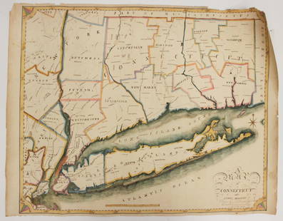
Sold2016EARLY MAP OF CONNECTICUT BY JOHN REIDFROM THE BEST AUTHORITIES"; ENGRAVED FOR THE AMERICAN EDITION OF WINTERBOTHAM'S HISTORY OF AMERICA, PUBLISHED BY JOHN REID, NEW YORK (2 SMALL BLEACH SPOTS LOWER LEFT & RIGHT); 14 1/2" X 17 1/2See Sold Price
Sold20201855 Colton Map of Connecticut -- Connecticut withTitle/Content of Map: 1855 Colton Map of Connecticut -- Connecticut with Portions of New York & Rhode Island Cartographer: J Colton Year/Place: 1855, New York Size: 12.5 X 15.3 in. This is a very niceSee Sold Price
Sold20221796 John Reid American Map of the West Indies - by John Reid. AN ACCURATE MAP OF THE WEST INDIES1796 John Reid American Map of the West Indies - by John Reid. AN ACCURATE MAP OF THE WEST INDIES WITH THE ADJACENT COAST OF AMERICA. Engraved by D. Martin. Published in New York in "An American AtlasSee Sold Price
Sold2018Tanner / Reid Map of South Carolina, 1796Tanner, Benjamin (1775-1848). State of South Carolina from the Best Authorities. Engraved map. J. Reid, 1796. 15" x 17" sheet. Published by John Reid New York. A very early and scarce folio map of SouSee Sold Price
Sold20221886 Tilden Map of Connecticut -- New Map of ConnecticutTitle: 1886 Tilden Map of Connecticut -- New Map of Connecticut Cartographer: S Tilden Year / Place: 1886, Hartford Map Dimension (in.): 20.9 X 27. 2 in. This is an excellent folding pocket map of ConSee Sold Price
Sold20231845 School Map of the Eastern United States1860 School Map of Connecticut.Clark & Tackaburys' Topographical Map of Connecticut..Map is 69 1/2" x 54 1/2"Condition, rolls up, creases, stains, overall wear, tears, some missing pieces to bottom boSee Sold Price
Sold20231860 School Map of Connecticut1860 School Map of Connecticut. Clark & Tackaburys' Topographical Map of Connecticut.. Map is 69 1/2" x 54 1/2" Condition, rolls up, creases, stains, overallSee Sold Price
Sold2018Bradford: Antique Map of Connecticut, 1838Title/Content of Map: Connecticut by Bradford Date Printed: 1838 Cartographer: Thomas G. Bradford Size: 14" x17" Material/Medium: Paper Provenance: New York A General Atlas of the World with a separatSee Sold Price
Sold2018Tanner: Antique Map of Connecticut, 1843Title/Content of Map: Connecticut by Tanner Date Printed: 1843 Cartographer: based on the work of H.C. Tanner Size: 17" x 14" Material/Medium: Paper Provenance: New York Hand colored engraved Map. FroSee Sold Price
Sold2021Connecticut, 1846, with Hartford & New Haven InsetsTitle/Content of Map: Connecticut, 1846, with Hartford & New Haven Insets Date Printed: 1846, Hildburghausen Cartographer: Joseph Meyer/Bibliographisches Instituts. Size: 14 1/2" 11 3/4" The beautifulSee Sold Price
Sold2018Colton: Antique Map of Connecticut, 1859Title/Content of Map: Connecticut by Colton Date Printed: 1859 Cartographer: H.J. Colton Material/Medium: Paper Size: 17 1/2" x 15" Hand colored,engraved. Published in New York in 'Colton's General AtSee Sold Price
Sold2017Colton: Antique Map of Connecticut, 1861Title/Content of Map: Connecticut by Colton Date Printed: 1861 Cartographer: J.H. Colton Material/Medium: Paper Size: 17 1/3" x 14" Hand colored steel engraved Map from 'Colton's General Atlas'. PubliSee Sold Price
Sold2017Bradford: Antique Map Connecticut & Rhode Island, 1835Title/Content of Map: Connecticut & Rhode Island Date Printed: 1835 Cartographer: T. G. Bradford Material/Medium: Paper Size: 9 1/2" x13" A Comprehensive Atlas Geographical, Historical & Commercial. PSee Sold Price
Sold2016Rand, McNally & Co: Connecticut, Rhode Island, 1898Map: Connecticut, Rhode Island Size: 21 x 15 inchesMaker: Rand, McNally & Co Date: 1898From: New Standard Atlas of the World No Reserve: This lot starts at $1 and has no reserve as a courtesy so thatSee Sold Price
Sold2022Janet Kellogg Reid O/B Landscape, Road with TreesJanet Kellogg Reid (Connecticut/New York/Wisconsin,1894-1988) oil on board landscape painting, possibly a California or Mediterranean scene, depicting a road lined with trees and rolling hills, cast iSee Sold Price
Sold20221866 Johnson Map of Massachusetts, Connecticut and Rhode Island -- Johnson's Massachusetts,Title: 1866 Johnson Map of Massachusetts, Connecticut and Rhode Island -- Johnson's Massachusetts, Connecticut and Rhode Island Cartographer: Johnson and Ward Year/Place: 1866, New York Dimensions: 17See Sold Price
Sold2023EARLY CONNECTICUT MAPHand drawn and colored; "Connecticut and Parts Adjacent", "drawn by Miss. Elizabeth L. Tredwell" "Christ Church Academy 1820", several edge tears; 23" x 30", F-GSee Sold Price
Sold20161797 AMOS DOOLITTLE CORRECT MAP OF CONNECTICUTEngraved for Dr. Trumbull's History of Connecticut. 14 x 16 1/2 inches.See Sold Price
Sold2023Map of Connecticut And Rhode Island 1780This early map is titled 'A New and accurate Map of Connecticut and Rhode Island. from the best Authorities' published in the Universal Magazine in 1780. The map features Long Island Sound and NarragaSee Sold Price
Sold2020Amos Doolittle Map of ConnecticutAmos Doolittle Map of Connecticut. Map: H 12", W 14-1/2" approx; frame size: H 20-1/4",. W 22-1/2". Professionally framed. Collection of Laura Mitler. Please see link for high res photos: https://www.See Sold Price
Sold2023Antique Map of Connecticut and Rhode IslandEngraved print map of Connecticut and Rhode Island. Highly detailed revolutionary war era map with towns, roads, rivers, islands, bays and more. Issued: 1776 Dimensions: 10"W x 8"HSee Sold Price
Sold20231886 J.B. Beers & Co. Map of ConnecticutUnited States,1885 Antique folding map of Connecticut created by J. B. Beers & Co. copyrighted 1885. Print on paper laid on textile,Approx. 52" x 46". From the collection of a Seekonk, Massachusetts eSee Sold Price
Jun 30Brandywine Valley AuctionsVintage American School New York Artist Roger Selchow Abstract Mid Century Modern Watercolor Signed$50
Jun 29Trillium Antique Prints & Rare BooksCarey, pub. 1805 - 3 Maps of the States of Massachusetts, Connecticut, & New Jersey$75
4 days LeftJasper521867 Beers Map of New York City Area -- Map of New York and Vicinity Accompanying "Atlas of New York$200
4 days LeftJasper521874 Holmes Plan of New York's Upper East Side -- Map of the Common Lands from 76th to 93rd Street$750
Jun 30Brandywine Valley AuctionsVintage American School Impressionist Philadelphia Artist Marion Butler Ewald Oil Painting #1$50
BonhamsQueen Anne Tiger Maple High Chest of Drawers, possibly Connecticut, late 18th/early 19th century.$500
2 days LeftSchilb Antiquarian Rare Books1890 Mark TWAIN Connecticut Yankee in King Arthurs Court Magic Novel$50(6 bids)
Jul 20Hess Fine Auctions19c Old Lyme Connecticut School Impressionist Oil Painting Woman Paints Flowers$150(3 bids)
Jul 11Eldred'sJAMES KINGSLAND (Connecticut, 1923-), "Cottage with Diamond Motifs"., Oil on canvas, 32" x 43".$250
5 days LeftUniversity ArchivesHartford County, Connecticut, Father and Son Track Accounts, 1755-1807$350
Jul 11Eldred'sSTEVEN CRYAN (Connecticut, Contemporary), The Martha's Vineyard ferry., Watercolor on paper, 6.5" x$150