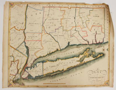
Sold2016EARLY MAP OF CONNECTICUT BY JOHN REIDFROM THE BEST AUTHORITIES"; ENGRAVED FOR THE AMERICAN EDITION OF WINTERBOTHAM'S HISTORY OF AMERICA, PUBLISHED BY JOHN REID, NEW YORK (2 SMALL BLEACH SPOTS LOWER LEFT & RIGHT); 14 1/2" X 17 1/2See Sold Price
Sold2023MAP, Connecticut, ReidConnecticut. John Reid, Connecticut from the Best Authorities, from Winterbotham's History of America, 1796 (circa). Black & White. This early and uncommon map of Connecticut was engraved by BenjaminSee Sold Price
Sold2016EARLY MAP OF VERMONT BY JOHN REID"FROM THE LATEST AUTHORITIES"; PUBLISHED BY JOHN REID; NEW YORK (FOXING AT RIGHT ON CREASE); 17 1/4" X 14" SIGHTSee Sold Price
Sold2016EARLY MAP OF RHODE ISLAND BY JOHN REID"FROM THE LATEST SURVEYS:, DATED 1796; FROM WINTERBOTHAMS HISTORY OF AMERICA; PUBLISHED BY JOHN REID; 17 1/2" X 13 1/4" SIGHTSee Sold Price
Sold2018Tanner / Reid Map of South Carolina, 1796Tanner, Benjamin (1775-1848). State of South Carolina from the Best Authorities. Engraved map. J. Reid, 1796. 15" x 17" sheet. Published by John Reid New York. A very early and scarce folio map of SouSee Sold Price
Sold20221796 Reid Map of Connecticut -- Connecticut from the Best AuthoritiesTitle: 1796 Reid Map of Connecticut -- Connecticut from the Best Authorities Cartographer: J Reid Year/Place: 1796 Dimensions: 13.9 X 17.1 in. Description: This is an excellent, early and uncommon mapSee Sold Price
Sold20201836 Church History Marsh Jews Illustrated Color MAPS1836 Church History Marsh Jews Illustrated Color MAPS Pagans Pilgrims Quakers John Marsh was a minister of a church in Haddam, Connecticut in the late 18th and early 19th centuries. At Haddam, Marsh pSee Sold Price
Sold2017Early Map of Georgia, John Payne, Circa 1810John Payne (American, 18th/19th century), "Georgia from the latest Authorities 1810"-1810/11. An early American engraved map of the Southern United States by mapmaker John Payne (American, 18th/19th cSee Sold Price
Sold2023EARLY CONNECTICUT MAPHand drawn and colored; "Connecticut and Parts Adjacent", "drawn by Miss. Elizabeth L. Tredwell" "Christ Church Academy 1820", several edge tears; 23" x 30", F-GSee Sold Price
Sold2017Important early map of St. Johns Island by T. JefferysA Map of the Island of St. John in the Gulf of St. Laurence...Thomas Jefferys (c. 1719 – 1771). Copperplate engraved map with handcolor in outline. London: Sayer & Bennett, 1775. 21 1/2 x 29 inchesSee Sold Price
Sold20221796 John Reid American Map of the West Indies - by John Reid. AN ACCURATE MAP OF THE WEST INDIES1796 John Reid American Map of the West Indies - by John Reid. AN ACCURATE MAP OF THE WEST INDIES WITH THE ADJACENT COAST OF AMERICA. Engraved by D. Martin. Published in New York in "An American AtlasSee Sold Price
Sold2023John Gibson, Early Map of Louisiana and British ColoniesThis interesting map was issued to illustrate the part of Louisiana being rapidly settled by British subjects at the conclusion of the French and Indian War. Publication: Gentleman’s Magazine anSee Sold Price
2019Early English road map by John OgilbyHeading: (Maps) Author: Ogilby, John Title: The Road from London to St. Neotts in Com. Hunt. Continued to Oakeham in Com Rutland Place Published: London Publisher: Date Published: 1675See Sold Price
2023MAP OF MARYLAND AND DELAWARE BY JOHN REID.Engraved map on laid paper, published by John Reid, New York. "The States of Maryland and Delaware, from the Latest Surveys, 1795" with Chesapeake Bay in the middle. Stains, minor creases, glued down.See Sold Price
Sold2018JOHN REID (AMERICAN, 18TH/19TH CENTURY) MAP OF VIRGINIAJOHN REID (AMERICAN, 18TH/19TH CENTURY) MAP OF VIRGINIA, on laid paper, title in oval cartouche to upper left corner "the STATE of / VIRGINIA / from the best Authorities / 1796", above "Published by JSee Sold Price
Sold2015Early map of Galway dated 1610, "Performet by JohnEarly map of Galway dated 1610, "Performet by John Speede," 15 by 20 inches, framed.See Sold Price
Sold2017(3) EARLY MAPS and a PRINT AFTER WILLIAM BLAKEIncluding: 1886 Fulton's Territory of Alaska, Hawaiian Group or Sandwich Islands, New Zealand, Feejee Islands, 1867 "The World in Two Hemispheres" by Mitchell (colored) and "The Day of Judgement" prinSee Sold Price
Sold2022EARLY MAP "AMERICA"John Speede 1626, Thomas Bassett / Richard Chillwell, Abraham Goos; "The Description of America", hand colored, center fold, slight foxing, framed size 19" x 23 1/2", G-G+See Sold Price
Sold2022EARLY MAP OF BRITAINJohn Speede / Thomas Basett, bookplate "Sanon Heptarchy" on reverse, hand colored, center fold, slight toning, framed size 19" x 23 1/2", G-G+See Sold Price
Sold2016A Map of the Tennassee Government, formerly part ofJohn Reid & W. Winterbotham. from the American Atlas. New York: J. Reid, L. Wayland & C. Smith, 1796. 2 Engraved Map Joined as Issued. 19 x 16 1/4 inchesSee Sold Price
Sold2022EARLY MAP OF AFRICA"Africae" "Newly Done into English John Speede / G. Humble 1626" engraved by Abraham Goos, bookplate "The Description of Africa" on reverse, hand colored; minor tear, foxing, toning, tape marks; frameSee Sold Price
Sold2022Map of "The State of Massachusetts from the Best Information 1796"Map of "The State of Massachusetts from the Best Information 1796," hand colored copper engraving, published by J. Reid, New York from John Reid's American Atlas the second folio-sized atlas publishedSee Sold Price
Sold2019[Map] The State of South Carolina 1796Tanner, Benjamin. "The State of South Carolina: from the best Authorities." New York: John Reid, [ca. 1796.] On heavy laid. Measuring from neat-lines 17" x 15". Lower edge remargined, mild toning, oneSee Sold Price
Sold2017Antique Map: John Smith's Map of VirginiaFramed antique map. John Smith's Map of Virginia. Well-engraved early 19th century reproduction. Discovered and Described by Captain John Smith, 1606. First published in 1612, this was one of the mostSee Sold Price
May 15University ArchivesDeclaration of Independence, Very Early British Publ. in Gentleman's Magazine & Rare Map$1,000
May 15University ArchivesEarly Arctic Exploration: "Journal of a Voyage for the Discovery of a North-West Passage" by William$500
1 day LeftTrillium Antique Prints & Rare BooksAudubon - American Robin or Migratory Thrush. 142$25(1 bid)
May 14Akiba Galleries(2 Pc) Allain Manesson Mallet Description De L'Univers 2 Vol. German Translation$200(1 bid)
May 16Potter & Potter AuctionsMap to Acquaint You with the Great Mission Bay Project. 194...$125(1 bid)
1 day LeftTrillium Antique Prints & Rare BooksPtolemy & Magini, pub. 1620 - Map of the Americas$50(1 bid)


![[Map] The State of South Carolina 1796: Tanner, Benjamin. "The State of South Carolina: from the best Authorities." New York: John Reid, [ca. 1796.] On heavy laid. Measuring from neat-lines 17" x 15". Lower edge remargined, mild toning, one](https://p1.liveauctioneers.com/3532/146911/74242458_1_x.jpg?height=310&quality=70&version=1564368564)


![[POTTERY]. Pair of Rare Illustrated Jugs Plus a Rare Illust... (1 of 1)](https://p1.liveauctioneers.com/928/328184/176813309_1_x.jpg?height=282&quality=70&version=1714496988)


