Sold2017NEW CENTURY ATLAS OF COUNTIES OF THE STATE OF NEW YORK,NEW CENTURY ATLAS OF COUNTIES OF THE STATE OF NEW YORK, EVENTS PUB. CO., 1912; (42) COLORED MAPS. 26 X 20" (IMPERFECTIONS)See Sold Price
Sold2021ca. 1929 RAILROAD UNITED STATES MAP SHOWING NEW YORKVintage Railroad Map, "MAP of THE UNITED STATES SHOWING NEW YORK CENTRAL LINES". Map by Rand McNally and Co. Includes printed information on the reverse. Tiny text along bottom partly reads; "NY 4-29"See Sold Price
Sold2021Large Lot Antique Hardback NY State History Books, 16+Large Lot of Antique Hardback New York State History Books. Includes: Documentary History of New York Vol 1-5, with fold-out maps, by EB O'Callaghan, MD, Albany, Weed Parson's & Co, 1849 PSee Sold Price
Sold2017FW Falls Long Island NY Yard Long ChromolithographUNITED STATES, EARLY 20TH CENTURY A yard long chromolithograph of Long Island, New York after F.W Falls. The map illustrates the topography of Long Island, Manhattan, and Montauk giving a representatiSee Sold Price
Sold2017Map of the States of New Hampshire & VermontCirca 1796 Antique Map Title: "Map of the States of New Hampshire and Vermont". Citation: by J. Denison. Amos Doolittle, Sculp. Approximate size: 10-3/8" x 8-3/8". Please note that this lot has a confSee Sold Price
Sold2017Smith: Map of Maine New Hampshire Vermont, 1853Title: Map No. 1 United States- Maine, New Hampshire, Vermont Date: 1853 Size: 9.5 x 11.5 inches From Smith's "Quarto Geography Atlas. Revised Edition, with New Census" Please note that this lot has aSee Sold Price
Sold2019USA 1911 Lot of 5 Maps from The Encyclopedia BritannicaNorth America, plus 4 State Maps - Wisconsin, Ohio, New Hampshire/Vermont, and New York. Lithograph Maps Published 1911, New York for "The Encyclopaedia Britannica" 11th Edition by Various ContributorSee Sold Price
Sold20211856 Wall Map of Strafford Co., New HampshireBy J. Chace Junr., 1856; Smith & Bartlett Publishers; George C. Peavey, Agent. The central hand-colored reference map portion depicting townships and land owners, with expanded downtown views of SalmoSee Sold Price
Sold2023An 1860 Map, Counties of New York, New Hampshire, Etc...Hand colored lithograph, by Samuel Augustus Mitchell (1790-1868). :County Map of the States of New York, New Hampshire, Vermont, Massachusetts, Rhode Island and Connecticut". Dimensions:15 1/2" x 23 1See Sold Price
Sold2022WOOD, Will B. How to Do Punch & Judy and Ventriloquism. New...WOOD, Will B. How to Do Punch & Judy and Ventriloquism. New York: N.Y Popular Pub. Co., ca. 1889. Hand-colored engraved wrappers. [16]pp. Booklet with four song lyrics (the latest copyrighted 1889), hSee Sold Price
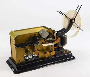
Sold2018J. H. Bunnell Telegraph Pen Register Sounder KeyUnited States,Circa 1900 Model KS-3107, serial number 9022. Tag on side states "J.H. BUNNELL & CO. NEW YORK, N.Y." 11 1/2" x 5" x 9",MetalSee Sold Price
Sold2022Robert Frost- ''New Hampshire''Robert Frost- ''New Hampshire''- woodcuts by J. J. Lankes, Henry Holt & Co., NY, 1924, hardcover, corners bumped and rubbed, writing in pencil on various pages, wiriing in ink and pencil on pastedownsSee Sold Price
Sold2021CHAUNCEY FOSTER RYDER (New York/New Hampshire,CHAUNCEY FOSTER RYDERNew York/New Hampshire, 1868-1949"Western N.Y., Steuben Co.". Signed lower left "Chauncey F. Ryder". Titled verso.Watercolor on paper, 10" x 14" sighSee Sold Price
Sold2022Reversed Painted on glass advertising signReverse painted on glass advertising sign for Granite State Fire Insurance Co., Portsmouth, New Hampshire, original frame, gold lettering on black background, 13 1/2" x 25 1/2" overall.See Sold Price
Sold2020New Hampshire 1886Title/Content of Map: New Hampshire 1886 Date Printed: 1886 Material/Medium: paper Size: 13.5x21 inches Additional Info: he People's Unrivaled Family Atlas of the World. People's Publishing Co, ChicagSee Sold Price
Sold2023Two 19th C. Democratic Republican TicketsBoth featuring Daniel Marcy for Governor of the state of New Hampshire.Largest approx: 8" x 3 3/4".See Sold Price
Sold2016The State of New Hampshire...John Reid & W. Winterbotham. from the American Atlas. New York: J. Reid, L. Wayland & C. Smith, 1796. Engraved Map with Orignal Hand-color in Outline. 16 1/4 x 19 1/4 inchesSee Sold Price
Sold2021Heimstreet & Co, Troy, N.Y. Cobalt Medicine Bottle"C. Heimstreet & Co, / Troy NY" 8 Panel, cobalt blue, applied top, medicine bottle 6 7/8" tall . 1 7/8" diameter. Very light surface wear. Date: Country (if not USA): State: New YorkCity: TroyProvenanSee Sold Price
Sold20231892 State of NH Atlas, D.H. Hurd & Co Boston1892 State of NH Atlas, D.H. Hurd & Co Boston An 1892 town and city atlas for the state of New Hampshire, size 18 x 15 1/2" along with a 1982 edition of the original 1858 and 1877 coppies of cheshireSee Sold Price
Sold20211823 Gazetteer New Hampshire INDIANS Slavery Map1823 Gazetteer New Hampshire INDIANS Slavery Map Early AMERICA Americana “A Gazetteer of the State of New-Hampshire” is a general view of 19th-century New Hampshire. Authors Moore and Farmer incluSee Sold Price
Sold2022Encyclo. Britannica 1890's Lot of 6 USA State MapsIncl New Mexico, New Hampshire, Indiana, Illinois, Oregon/Washington, and New Jersey. Lithograph Map Published 1875-98, Edinburgh & London for "Encyclopaedia Britannica" Ninth Edition. Paper Size: 10.See Sold Price
Sold2022Encyclo. Britannica C1880 Lot of 8 US State MapsIncl Alabama, Nebraska, Nevada, New Hampshire, New Jersey, New Mexico, Ohio and Oregon/Washington. Lithograph Maps Published 1875-98, Edinburgh & London for "Encyclopaedia Britannica" Ninth Edition. PSee Sold Price
Sold2019Bryce, James 1881 Lot of 10 Maps of Canada & USADominion of Canada, North America, Middle States. New York, Pennsylvannia, New Jersey, Delaware and Maryland, New England States. Maine, New Hampshire, Vermont, Massachusetts, Rhode Island and ConnectSee Sold Price
Sold2017Colton MAP OF THE STATE OF MISSISSIPPI 1867 EngravedDetails: COLTON, George W. (1827-1901) & Charles B. (1832-1916). Colton's Map of the State of Mississippi. New York: G.W. & C.B. Colton & Co., 1867. Engraved folding pocket map, full contemporary hanSee Sold Price
2 days LeftJasper52Vintage Pair of Harrison Fisher Chromolithographs- Homeward Bound & Goodnight- Embellished by$50
7 days LeftJasper521890s Cram Map of Vermont [verso] New Hampshire -- Vermont [verso] New Hampshire$30
3 days LeftJasper52EARLY VINTAGE QUAKER OATS CO MOTHERS BARLEY 1LB BOX GREAT ADVERTISING & DISPLAY$50
9 hrs LeftJasper52Lucile by Owen Meredith Worthington NY HC Rare 1889 Ornate Decoration Antique VG$200
May 16Potter & Potter Auctions[PICTORIAL MAPS – TRAVEL]. Three Pictorial Maps. 1940s/50s....$150
Jun 12Dan Morphy AuctionsPHELPS’S TRAVELERS GUIDE THROUGH THE UNITED STATES; CONTAINING UPWARDS OF SEVEN HUNDRED$1,000
May 25Eagles Corps International LLC(16) Civil War New Hampshire Veterans Medals and Ribbons$7(2 bids)


![WOOD, Will B. How to Do Punch & Judy and Ventriloquism. New...: WOOD, Will B. How to Do Punch & Judy and Ventriloquism. New York: N.Y Popular Pub. Co., ca. 1889. Hand-colored engraved wrappers. [16]pp. Booklet with four song lyrics (the latest copyrighted 1889), h](https://p1.liveauctioneers.com/928/242430/125665194_1_x.jpg?height=310&quality=70&version=1648565335)


![1890s Cram Map of Vermont [verso] New Hampshire -- Vermont [verso] New Hampshire (1 of 2)](https://p1.liveauctioneers.com/5584/328338/176911596_1_x.jpg?height=282&quality=70&version=1715113718)


![[PICTORIAL MAPS – TRAVEL]. Three Pictorial Maps. 1940s/50s.... (1 of 4)](https://p1.liveauctioneers.com/928/325952/175495561_1_x.jpg?height=282&quality=70&version=1712935174)


