Sold2024A scarce and very large plan of Montreal[MAP-CANADA] ADAMS, JOHN, surveyor. Map of the City and Suburbs of Montreal ... Constructed from a New Survey, 1825 by John Adams. New York: Engraved by J. D. Stout, 1825. Engraved map on three largeSee Sold Price
Sold202419th c. Quebec & Montreal City MapsDouble-sided engraving of city plans of Quebec and Montreal in Canada. Engraved by Fisk & Co. and published by Hunt & Eaton, New York, ca. 1891.See Sold Price
Sold2023[CANADIAN ANTIQUE MAP] CITY [PLAN] OF QUEBEC. 1830[CANADIAN ANTIQUE MAP] CITY [PLAN] OF QUEBEC.Engraved by J.&.C. Walker.Image size (approx): 7.1/2"x9.1/4" Original engraved map, circa 1830s. Original antique map city plan, of The City of Montreal. SSee Sold Price
Sold2019Unknown, "Asia from the Best Authorities," togetherUnknown, "Asia from the Best Authorities," together with two leaflets, "Neue Zeitungen von Gelehrten Sachen," 1733 and "The World" by Adam Fitz-Adam, 1754, Map- H.- 8 1/2 in., W.- 10 in. (3 Pcs.)See Sold Price
Sold2023Sebastian C. Adams - Synchronological Chart, Illustrated Panorama of History, Chronological Chart ofLot 56 Sebastian C. Adams American (1825-1928) Synchronological Chart, Illustrated Panorama of History, Chronological Chart of Ancient Modern and Biblical History with Maps , Group of 3 (1884) chromoSee Sold Price
Sold2019LARGE 1912 MAP, CITY OF AUSTIN, TEXAS, 73" x 44"Large faded unframed map, "Tobins Updated Map of the City of Austin, Mar. 1912", showing downtown blocks, the capitol building, East Avenue that became I35 and neighborhoods, 73.75"h, 44.5"w Start PriSee Sold Price
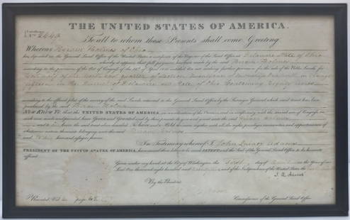
Sold2023Signed By US President John Quincy Adams 1825 American Land Grant Delaware County OHTitle:1825 American Land Grant Signed By US President John Quincy Adams Description: Framed 1825 Land Grant signed by then-President John Quincy Adams to a one Hiram Holmes of Delaware County, OH forSee Sold Price
Sold20191872 Asher and Adams Map of Arkansas and Western IndianTitle: 1872 Asher and Adams Map of Arkansas and Western Indian Territory -- Asher & Adams's Arkansas and Portion of Indian Territory Date: 1872 New York Cartographer: Asher & Adams Size: 15.8 x 22.8 iSee Sold Price
Sold2021Map, City of New York 1824Map of the City of New York 1824. Map of Property in the Estate of Teunis Tiebout .See Sold Price
Sold2022WORLD MAP & MONTREAL MAPGibson, John. A PARTICULAR MAP, TO ILLUSTRATE GEN. AMBERST'S EXPEDTIION, TO MONTREAL; WITH A PLAN OF THE TOW & DRAUGHT OF YE ISLAND (London: The Gentleman's Magazine, ca. 1760). Copper engraving. HandSee Sold Price
Sold2017SDUK: Antique Map, City Plan of Philadelphia, 1847Title/Content of Map: 'PHILADELPHIA' Antique town city map plan. Inset US Bank, Exchange. Date Printed: 1847 Image Size: Approx 39.5 x 31.5cm, 15.5 x 12.5 inches (Large) Type: Antique steel engraved mSee Sold Price
Sold20231905 Rollandet's Wall Map City and County of Denver, Colorado1905 Rollandet's Wall Map City and County of Denver, Colorado. This would be great to frame.Dimensions are 42 in h x 41.25 in w x 0 in d. Condition is fair. There is heavy wear along the edge. PleaseSee Sold Price
Sold20221872 Asher and Adams Map of Florida -- Asher & Adams' FloridaTitle: 1872 Asher and Adams Map of Florida -- Asher & Adams' Florida Cartographer: Asher & Adams Year/Place: 1872 New York Dimensions: 15.8 x 22.8 in. Description: This is a superb, large map of FloriSee Sold Price
Sold2017Asher & Adams: Map of Indian Territory, 1874Map: Hand Colored Map of Indian Terratory Maker: Asher & Adams Date: 1874 Size: Approx. 16x22 inches First edition of this large format railroad map of IndianTerritory, from Asher & Adams' Atlas of thSee Sold Price
Sold2017Mallet: Antique Map, City View of Cuzco, Peru, 1683Title: 'Cusco' Decorative view of the city of Cuzco, Peru. Date Printed: 1683 Image Size: Approx Overall page size 13 x 21cm approximately (5 x 8 inches); image size 10.5 x 14.5cm approximately (4 x 5See Sold Price
Sold20181872 Asher and Adams Map of Eastern Texas -- Asher &Reserve Reduced! Title/Content of Map: 1872 Asher and Adams Map of Eastern Texas -- Asher & Adams' Texas Date: 1872 New York Cartographer: Asher & Adams Size: 22.2 X 15.8 in. A very nice, large map ofSee Sold Price
Sold20181872 Asher and Adams Map of Florida -- Asher & Adams'Title/Content of Map: 1872 Asher and Adams Map of Florida -- Asher & Adams' Florida Date: 1872 New York Cartographer: Asher & Adams Size: 15.8 x 22.8 in. A very nice, large map of Florida. The major cSee Sold Price
Sold2017SDUK: Antique Map, City Plan of Athens, 1847Title/Content of Map: 'ATHENS.; inset Acropolis' Antique town city map plan Date Printed: 1847 Image Size: Approx 35.5 x 41.0cm, 14 x 16 inches (Large) Type: Antique steel engraved map with original oSee Sold Price
Sold20191872 Asher and Adams Map of Southern California andTitle/Content of Map: 1872 Asher and Adams Map of Southern California and Nevada -- Asher & Adams' California & Nevada Southern Portion Date: 1872 New YorkCartographer: Asher & Adams Size: 15.8 x 22.8See Sold Price
Sold2017Mallet: Antique Map City Plan of Madrid, 1683Title of the Map: 'Madrid' Decorative plan of the city. Churches. Spain. Date Printed: 1683 Image Size: Approx Overall page size 13 x 21cm approximately (5 x 8 inches); image size 10.5 x 14.5cm approxSee Sold Price
Sold20191872 Asher and Adams Map of Kansas -- Asher & Adams'Title: 1872 Asher and Adams Map of Kansas -- Asher & Adams' Kansas Date: 1872 New York Cartographer: Asher & Adams Size: 15.8 x 22.8 in. Additional Information: A very nice, large map of Kansas with mSee Sold Price
Sold2023Vintage Framed Map, City of Kingston NYhand colored map by Thomas Hunter; Burleigh Litho. Frame size: 28 1/4" high, 36 3/4" wide. Light toning, small stain.See Sold Price
Sold2017Mallet: Antique Map, City View of Jerusalem, 1683Title: 'Ierusalem Moderne' Shows Muslims praying and many mosques. View of the city. Date Printed: 1683 Image Size: Approx Overall page size 13 x 21cm approximately (5 x 8 inches); image size 10.5 x 1See Sold Price
Sold20181872 Asher and Adams Map of United StatesTitle/Content of Map: 1872 Asher and Adams Map of United States -- Asher & Adams' United States and Territories Date Printed: 1872 New York Cartographer: Asher & Adams Size: 15.8 x 22.8 in. A very nicSee Sold Price
2 days LeftSwann Auction GalleriesHENRY F. WALLING (1825-1889) Map of the City of New York and Its Vicinity. 1866.$1,900
1 day LeftJasper52FLORENCE FIRENZE. Antique town city map plan. Key buildings profiles. SDUK 1844$260
1 day LeftJasper52WARSAW WARSZAWA. Antique town city map plan. Building profiles.Colour.SDUK 1844$500
65 Lots AwayChampagne AuctionsBosworth, Newton - Hochelaga depicta...history and present state...city of Montreal, 1st edition -CA$75
2024Rapid Estate Liquidators and Auction GalleryCoca Cola 1993 New Orleans Basketball TubeSee Sold Price
1 day LeftJasper52Delineatio Geometrica Urbis Haffniae Daniae… Copenhagen. DAHLBERGH 1696 map$320
2 days LeftSwann Auction GalleriesEGBERT L. VIELE; and G.W. & C.B. COLTON Map of the City of New York Showing the Proposed Route of$600
22 mins LeftJasper521909 but 2007 Map of the City and County of San Francisco -- Map of the City and County of San$30
1 day LeftJasper52MOSCOW MOSKAU Москва Antique city town map plan & panorama SDUK$480


![A scarce and very large plan of Montreal: [MAP-CANADA] ADAMS, JOHN, surveyor. Map of the City and Suburbs of Montreal ... Constructed from a New Survey, 1825 by John Adams. New York: Engraved by J. D. Stout, 1825. Engraved map on three large](https://p1.liveauctioneers.com/292/326828/175962870_1_x.jpg?height=310&quality=70&version=1713473479)


![[CANADIAN ANTIQUE MAP] CITY [PLAN] OF QUEBEC. 1830: [CANADIAN ANTIQUE MAP] CITY [PLAN] OF QUEBEC.Engraved by J.&.C. Walker.Image size (approx): 7.1/2"x9.1/4" Original engraved map, circa 1830s. Original antique map city plan, of The City of Montreal. S](https://p1.liveauctioneers.com/8321/286473/155233365_1_x.jpg?height=310&quality=70&version=1686787412)